Is Japan going to sink? pt.1
Record land mass movement has been observed in Miyagi. Quake-hit Oshika Peninsula moved 5.3 meters and dropped 1.2 meters according to Geospatial Information Authority. Government showed both records data on Saturday. Geospatial Information Authority based in Tsukuba issued a report that says that peninsula on the Pacific coast moved in East-SouthEast direction toward the quake epicenter.
Earthquake also triggered land mass movements in many areas ranging from northeastern region of Tohoku to the Kanto region including Tokyo. In Iwate prefecture, a point in Yamada (north of Miyagi) moved 25cm to the east, while a point in Chiba's Choshi, south of Miyagi, moved 17 cm to the east.

Authorities in Japan constructed a post seismic slip distribution model using surface displacement data observed by the GPS Earth Observation Network System (GEONET) for the 2011 off the Pacific coast of Tohoku Earthquake. You can visit this page for more data and charts.
Eastward displacements are observed along the Pacific coast from Aomori Prefecture to Chiba Prefecture.
The observed postseismic displacement partly includes crustal deformation due to aftershocks. A postseismic slip expands in and around the inferred coseismic slip area. In particular, relative large slips are estimated in the northwest and in the south (off Choshi) of the coseismic slip area.

Maximum Postseismic Horizontal Displacement
~20cm (Data from 2011-03-11 18:00 to 2011-03-16 09:00 JST)
~15cm (Data from 2011-03-11 18:00 to 2011-03-15 03:00 JST)
~14cm (Data from 2011-03-11 18:00 to 2011-03-14 03:00 JST)
~12cm (Data from 2011-03-11 18:00 to 2011-03-13 06:00 JST)
Maximum Postseismic Slip
~70cm (Data from 2011-03-11 18:00 to 2011-03-16 09:00 JST)
~60cm (Data from 2011-03-11 18:00 to 2011-03-15 03:00 JST)
~50cm (Data from 2011-03-11 18:00 to 2011-03-14 03:00 JST)
~42cm (Data from 2011-03-11 18:00 to 2011-03-13 06:00 JST)
Off Choshi:
~38cm (2011-03-11 18:00 to 2011-03-16 09:00 JST)
~35cm (2011-03-11 18:00 to 2011-03-15 03:00 JST)
~28cm (2011-03-11 18:00 to 2011-03-14 03:00 JST)
~25cm (2011-03-11 18:00 to 2011-03-13 06:00 JST)
Moment Magnitude
Mw8.16 (Data from 2011-03-11 18:00 to 2011-03-16 09:00 JST)
Mw8.13 (Data from 2011-03-11 18:00 to 2011-03-15 03:00 JST)
Mw8.08 (Data from 2011-03-11 18:00 to 2011-03-14 03:00 JST)
Mw8.03 (Data from 2011-03-11 18:00 to 2011-03-13 06:00 JST)
The 2011 off the Pacific coast of Tohoku Earthquake (Japan Meteorological Agency) issued a warning considering a ground sinking and floods. You can read the full warning here.
The 2011 off the Pacific coast of Tohoku Earthquake largely sank the ground level of the Pacific coast of Tohoku region and northern part of Kanto region. The risk of the submergence and flood in these regions has become larger than before the 2011 off the Pacific coast of Tohoku Earthquake. Therefore, it is necessary to pay special attention to the tide level and to prepare for the submergence and flood in these regions, especially during the spring tide, when the flood tide level becomes higher than usual.
Special attention should be paid to the tide level around spring tides (until the end of April);
from 18 to 26 March, 2011
from 1 to 11 April, 2011
from 16 to 24 April, 2011


It was hard to collect GPS data points after the earthquake. The results during an earthquake in the east-southeast direction showed moving about 5.3m for Oshika Peninsula, about 1.2m found that there was a new settlement. Moreover, the continued gradual deformation after an earthquake was in wide range around the focal area, after a change from large earthquakes it was greater than 20 cm.
Preliminary reports by GSI:
Crustal deformation due the earthquale (horizontal)
Crustal deformation associated with earthquakes (vertical)
Deformation after the earthquake (horizontal)
Mainshock at the reference point "e Oshika" (Ishinomaki City, Miyagi Prefecture) is about 5.3m east-southeast direction of movement, such as subsidence of about 1.2m, were observed during the deformation in a wide range from the Kinki region of Japan. The figure, in Shimane Prefecture GEONET "Misumi", which is calculated by assuming that the earthquake did not move around.
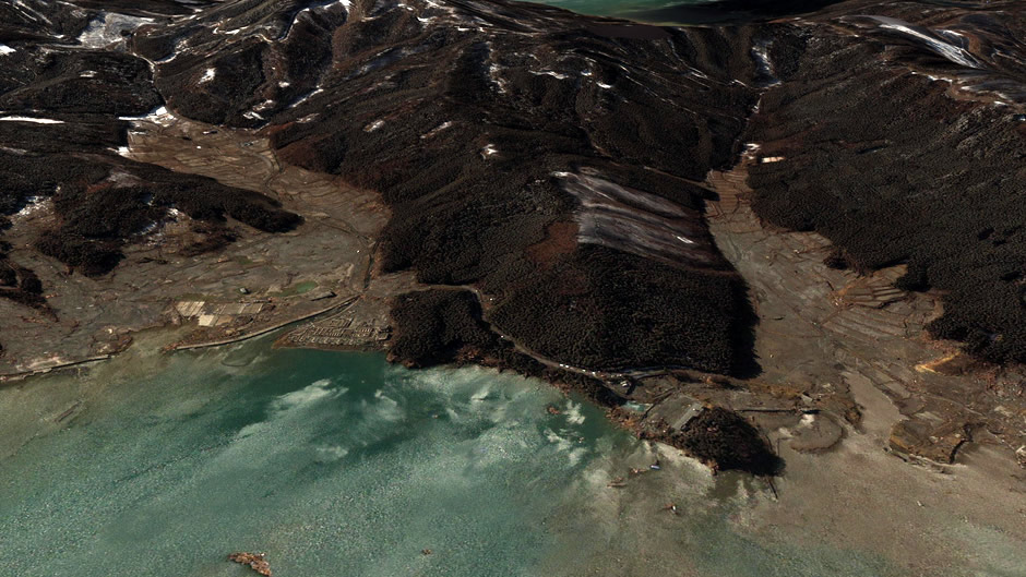
Google released satellite images revealing the devastation in the Oshika Peninsula and Iigoham caused by the March 11 tsunami and earthquake. The satellite images are available here and here.

As of March 16, the aftershocks larger than magnitude 7.0 occurred 3 times, and those larger than 6.0 occurred 48 times. The largest aftershock occurred at 15:25 JST, March 11 (magnitude 7.5). The aftershocks have occurred in the large area off the coast of Iwate, Miyagi, Fukushima, and Ibaraki Prefectures. When compared to past cases, the activity of aftershocks is very high. According to JMA the possibility of aftershocks with maximum seismic Intensity of 5+ or higher is 40% for the 3-day period from 16 March, followed by 20% for the 3-day period from 19 March to 12:00 , 22 March.
The areas closest to the epicenter of the quake jumped a full 4 meters (13 feet) closer to the United States, geophysicist Ross Stein at the United States Geological Survey told The New York Times. As Japan’s eastern coastline sunk, the tsunami’s waves rolled in.
Commenting rules and guidelines
We value the thoughts and opinions of our readers and welcome healthy discussions on our website. In order to maintain a respectful and positive community, we ask that all commenters follow these rules:
We reserve the right to remove any comments that violate these rules. By commenting on our website, you agree to abide by these guidelines. Thank you for helping to create a positive and welcoming environment for all.