Eruption of Tungurahua sends ash up to 7 km into the air, Ecuador
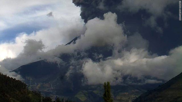
Ashes from Tungurahua, 140 km south of Quito, Ecuador, rose more than 7 kilometers (4 miles) into the air on Tuesday. Schools are closed and residents evacuated in areas near volcano.
Six eruptions and significant ash cloud were detected and authorities issued an alert. Officials first detected increased activity in the volcano on April 20th with monitors observing regular small eruptions of ash and gas plumes.
Ecuadorian Geophysics Institute EPN said that damages to crops, pastures and small effect to the health of people are already evident. Tungurahua erupted in December, sending ash and lava spewing nearly a mile into the sky.
Major eruptions also occurred in August 2006 and February 2008, according to the government's emergency management agency.

Image credit: NASA / Earth Observatory
Tungurahua means "throat of fire" in the native Quechua language.
The glacier-capped, 5023 meters high stratovolcano has erupted periodically since 1999, when increased activity led to the temporary evacuation of the city of Banos at the foot of the volcano. Nearby notable mountains are Chimborazo (6,267 m) and El Altar (5,319 m). It rises above the small thermal springs town of Baños de Agua Santa (1,800 m) which is located at its foot 8 km to the north. Tungurahua is part of the Sangay National Park.
Tungurahua's eruptions are strombolian. They produce andesite and dacite. All historical eruptions originated from the summit crater and have been accompanied by strong explosions, pyroclastic flows and sometimes lava flows. In the last 1,300 years Tungurahua entered every 80 to 100 years into an activity phase of which the major have been the ones of 1773, 1886 and 1916-1918.
Activity continued at a medium level until May 2006, when activity increased dramatically, culminating in violent eruptions on 14 July 2006 and 16 August 2006. The 16 August 2006 eruption has been the most violent since activity commenced in 1999. This eruption was accompanied by a 10 km high ash plume which spread over an area of 740 by 180 km, depositing ash and tephra to the southwest of the volcano. Several pyroclastic flows were generated that killed seven people, and destroyed a number of hamlets and roads on the eastern and northwestern slopes of the volcano.
The seven people who died were a family of five and two scientists. A further eruption and evacuation occurred on 4 December 2010. Ecuador's National Agency of Risk Control issued a "red alert", later downgraded to orange. The Ecuadorian Institute for Geophysics reported a rapid increase in seismic activity, a number of explosions and an ash cloud reaching 2 kilometers (1.2 mi) in height.
Commenting rules and guidelines
We value the thoughts and opinions of our readers and welcome healthy discussions on our website. In order to maintain a respectful and positive community, we ask that all commenters follow these rules.