Hurricane season starts today in Eastern Pacific
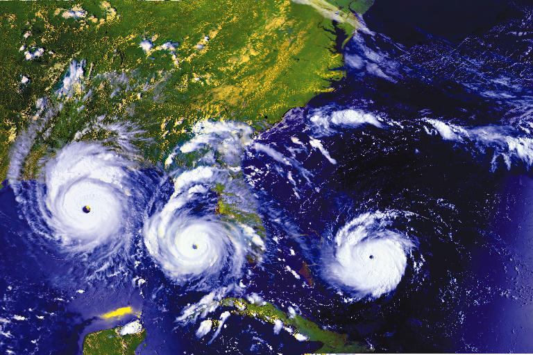
May 15th marks the official start of the 2011 hurricane season in the Eastern Pacific, a season which is expected to exceed the amount of named tropical systems from last year by twofold. AccuWeather.com meteorologists are predicting an average number of tropical systems to develop in the Eastern Pacific this year. The basin averages 15 tropical storms each season. Out of those, nine become hurricanes, with four reaching major hurricane status.
Fifteen named storms would more than double the total from last year. Only seven named storms formed in the Eastern Pacific in 2010, with three reaching hurricane status. A strengthening La Niña can be partially attributed to the lack of tropical storms last year. (2010 Eastern Pacific hurricane season). A weakening La Niña, on the other hand, will bring the basin’s hurricane season back to normal this year.
 There are clusters of thunderstorms currently streaming across the Eastern Pacific, but none show signs of future development. The first tropical storm to develop in the Eastern Pacific this year will acquire the name “Adrian.” Hurricane season in the Eastern Pacific will run until November 30, which coincides with the end of hurricane season in the Atlantic Basin.
The 2011 Atlantic Basin hurricane season does not officially begin until June 1. The earlier start time in the Eastern Pacific reflects how this basin typically turns active faster than the Atlantic. On average, June 9 is when the first tropical storm is named in the Eastern Pacific. In the Atlantic, that date is July 10.
Hurricanes typically develop much quicker in the Eastern Pacific than the Atlantic. The average first date for a hurricane to form in the Eastern Pacific is June 24, but not until August 14 in the Atlantic. Despite the Eastern Pacific being rather active, the majority of tropical storms and hurricanes never threaten land. A typical Eastern Pacific tropical system will head westward into open and progressively cooler ocean waters, dissipating in the process.
Occasionally, tropical storms and hurricanes will target Mexico and parts of Central America. Though less frequently, some tropical systems have threatened Hawaii. Hurricane Felicia approached Hawaii in 2009, but weakened below tropical depression status prior to reaching the islands.
Since records began, the cool water that lies offshore of California has protected the state from direct hits by tropical storms and hurricanes in every year but one. In September 1939, an unnamed tropical storm pressed onshore at Long Beach, California with maximum sustained winds of 50 mph.
Two other storms have moved into Arizona at tropical storm strength. The first was once-Hurricane Joanne in October 1972, followed by once-Hurricane Kathleen in September 1976.
No systems have reached the Southwest at hurricane strength. (AccuWeather)

To qualify as a Category 5 hurricane on the Saffir-Simpson hurricane intensity scale, maximum sustained winds must exceed 155 mph (135 kt). Through 2008, only 32 Atlantic storms have reached this intensity. 2005 was by far the most popular year for Category 5 storms, with Emily, Katrina, Rita and Wilma (of course, 2005 was a record year in many respects (Wikipedia).
When and Where Do Hurricanes Occur?
Hurricanes (by whatever name) are by far most common in the Pacific Ocean, with the western Pacific being most active. In some years, the Philippines are struck by more than 20 tropical storms and typhoons. The term applied to various storms depends on their location. Only one hurricane force storm has ever occurred in the South Atlantic – Hurricane “Catarina” in 2004.

When hurricanes strike is also determined by location. Below is a brief description of each basin’s “hurricane season.” More information can be obtained from the NOAA Hurricane FAQ.
ATLANTIC: Hurricane season in the Atlantic runs from June 1 to November 30. Storms outside of these dates are not unheard of. As you can see from the graph, based on the average of 150 years of storms, activity ramps up in August, and peaks once in early September, then again in October. More statistics are available here. Persons traveling to areas near the Atlantic Basin should exercise caution during the entire Hurricane Season.
EASTERN PACIFIC: The Eastern Pacific basin’s hurricane season is from May 15th to November 30th, peaking in late August or early September.
WESTERN PACIFIC: The Western Pacific basin’s hurricane season is mostly from July 1 to November 30, peaking in late August or early September, though storms can occur year-round.
SOUTH PACIFIC: The South Pacific basin’s hurricane season is from October 15 to May 15, reaching a peak in late February or early March.
INDIAN OCEAN: The Indian basin’s hurricane season is from April 1 to December 31 for the northern Indian Ocean, and from October 15 to May 31 in the southern region.

The winds attain maximum force close to the point of lowest pressure—about 724 torr (unit of pressure), or about 28.5 in. of mercury. The diameter of the area affected by winds of destructive force may exceed 240 km (150 mi). Gale winds prevail over a larger area, averaging 480 km (300 mi) in diameter. The strength of a hurricane is rated from 1 to 5. The mildest, Category 1, has winds of at least 120 km/hr (74 mph). The strongest (and rarest), Category 5, has winds that exceed 250 km/hr (155 mph). Within the eye of the storm, which averages 24 km (15 mi) in diameter, the winds stop and the clouds lift, but the seas remain very violent.
Hurricanes generally move in a path resembling the curve of a parabola. In the northern hemisphere the storms usually travel first in a north-westerly direction and in the higher latitudes turn towards the north-east. In the southern hemisphere the usual path of the hurricane is initially to the south-west and subsequently to the south-east. Hurricanes travel at varying rates. In the lower latitudes the rate ranges from 8 to 32 km/hr (5 to 20 mph) and in the higher latitudes it may increase to as much as 80 km/hr (50 mph). Those areas in which the hurricane winds blow in the same direction as the general movement of the storm are subjected to the maximum destructive violence of the hurricane.
Since 1943 military aircraft have been flying into hurricanes to measure wind velocities and directions, the location and size of the eye, the pressures within the storms, and their thermal structure. A coordinated system of tracking hurricanes was developed in the mid-1950s, and periodic improvements have been made over the years. Radar, sea-based recording devices, geosynchronous weather satellites, and other devices now supply data to hurricane monitoring centres, such as the National Hurricane Center in Florida, which follows each storm virtually from the beginning.
Improved systems of prediction and communication have been able to help minimize loss of life in hurricanes, but property damage is still heavy, especially in coastal regions. The strongest hurricane to hit the western hemisphere in the 20th century, called Gilbert, devastated Jamaica and parts of Mexico in 1988 with winds that gusted up to 350 km/hr (218 mph). The United States is often affected by destructive hurricanes, the most recent being Andrew (1992), with an estimated $12 billion in damage, more than 50 dead, and thousands left homeless. Agnes (1972), with $3 billion in damage and 134 deaths and Hugo (1989), with more than $4 billion in damage and more than 50 deaths, also wreaked tremendous destruction. In Britain, one of the world’s windiest countries, but one not normally affected by hurricanes, the hurricane that swept the southern half of the country in 1987 exceeded 100 mph and felled millions of trees.
Hurricane Stages
| Tropical Wave | A low pressure trough moving generally westward with the trade winds. |
| Tropical Disturbance | An organized area of thunderstorms that usually forms in the tropics. Typically, they maintain their identity for 24 hours and are accompanied by heavy rains and gusty winds. |
| Tropical Cyclone | A generic term for any organized low pressure that develops over tropical and sometimes sub-tropical waters. Tropical depressions, tropical storms, and hurricanes are all example of tropical cyclones. |
| Tropical Depression | An organized area of low pressure in which sustained winds are 38 mph or less. |
| Tropical Storm | A tropical cyclone with maximum sustained wind speeds that range from 39 to 73 mph. |
| Hurricane | A tropical cyclone with sustained winds of at least 74 mph. |
Hurricanes and typhoons usually move westward at about 10 mph (16 kph) during their early stages and then curve poleward as they approach the western boundaries of the oceans at 20° to 30° lat., although more complex tracks are common.
In the Northern Hemisphere, incipient hurricanes usually form over the tropical Atlantic Ocean and mature as they drift westward; hurricanes also form off the west coast of Mexico and move northeastward from that area.
An average of 3.5 tropical storms per year eventually mature into hurricanes along the east coast of North America, usually over the Caribbean Sea or the Gulf of Mexico between June and November; one to three of these approach the U.S. coast annually, some changing their direction from west to northeast as they develop. Hurricanes and typhoons of the N Pacific usually develop sometime between May and December; typhoons and tropical cyclones of the Southern Hemisphere favor the period from December through April; Bay of Bengal and Arabian Sea tropical cyclones occur either between April and June or September and December, the times of the onset and retreat of the monsoon winds.

Formation of HurricanesA cyclone that eventually reaches hurricane intensity first passes through two intermediate stages known as tropical depression and tropical storm. Hurricanes start over the oceans as a collection of storms in the tropics. The deepening low-pressure center takes in moist air and thermal energy from the ocean surface, convection lifts the air, and high pressure higher in the atmosphere pushes it outward. Rotation of the wind currents tends to spin the clouds into a tight curl; as the winds reach gale force, the depression becomes a tropical storm. The mature hurricane is nearly circularly symmetrical, and its influence often extends over an area 500 mi (805 km) in diameter.
As a result of the extremely low central pressure (often around 28.35 in./72 cm but sometimes considerably lower, with a record 25.91 in./65.8 cm registered in a 1958 typhoon) surface air spirals inward cyclonically (counterclockwise in the Northern Hemisphere and clockwise in the Southern Hemisphere), converging on a circle of about 20 mi (30 km) diameter that surrounds the hurricane’s “eye.” The circumference of this circle defines the so-called eye wall, where the inward-spiraling, moisture-laden air is forced aloft, causing condensation and the concomitant release of latent heat; after reaching altitudes of tens of thousands of feet above the surface, this air is finally expelled toward the storm’s periphery and eventually creates the spiral bands of clouds easily identifiable in satellite photographs.
The upward velocity of the air and subsequent condensation make the eye wall the region of heaviest precipitation and highest clouds. Because the outward increase in pressure is greatest there, the eye wall is also the region of maximum wind speed. By contrast, the hurricane eye is almost calm, experiences little or no precipitation, and is often exposed to blue sky. Temperatures in the eye are 10°F to 15°F (5°C–8°C) warmer than those of the surrounding air as a result of sinking currents at the hurricane’s core.
Damage Caused by Hurricanes
Saffir-Simpson Hurricane Scale
| Category | Winds (MPH) | Pressure (Millibars) | Pressure (Inches) | Storm Surge (Feet) |
Damage |
| 1 | 74-95 | <980 | <28.94 | 4′-5′ | Minimal |
| 2 | 96-110 | 979-965 | 28.91-28.50 | 6′-8′ | Moderate |
| 3 | 111-130 | 964-945 | 28.47-27.91 | 9‘-12′ | Extensive |
| 4 | 131-155 | 944-920 | 27.88-27.17 | 13′-18′ | Extreme |
| 5 | >155 | <920 | <27.17 | >18′ | Catastrophic |
The 1970 Bay of Bengal tropical cyclone killed about 300,000 persons, mainly by drowning. In the United States, Hurricanes Hugo (1989) in Charleston, S.C., and Andrew (1992) in Homestead, Fla., caused billions of dollars worth of damage.
Commenting rules and guidelines
We value the thoughts and opinions of our readers and welcome healthy discussions on our website. In order to maintain a respectful and positive community, we ask that all commenters follow these rules:
We reserve the right to remove any comments that violate these rules. By commenting on our website, you agree to abide by these guidelines. Thank you for helping to create a positive and welcoming environment for all.