Massive dust storm descends on Phoenix area
A massive dust storm descended on the Phoenix area on Tuesday night, drastically reducing visibility and delaying flights as strong winds toppled trees and caused power outages for thousands of residents in the valley.

The towering dust cloud that hit the area had originated in an afternoon storm in the Tucson area before moving north across the desert. Before bearing down on the Phoenix valley, radar data showed the storm’s wall of dust had reached as high as 8,000 to 10,000 feet.
Once it neared the valley, the cloud had fallen to some 5,000 feet, according to the weather service. KSAZ-TV in Phoenix reported the storm appeared to be roughly 50 miles wide in some spots, and it briefly blanketed the city’s downtown at around nightfall.The storm was part of the Arizona monsoon season, which typically starts in mid-June and lasts through Sept. 30.
The National Weather Service says strong winds with gusts of more than 60 mph rapidly moved the dust cloud northwest through Phoenix and the surrounding cities of Avondale, Tempe and Scottsdale. More than a dozen communities in the area also were placed under a severe thunderstorm watch until 11 p.m.
Some 8,000 Salt River Project utility customers were left without power, KNXV-TV reported late Tuesday.
The Federal Aviation Administration said on its website that because of low visibility in the area, no Phoenix-bound flights were allowed to leave Las Vegas or Los Angeles airports until 9 p.m., and flights at the airport were grounded for about an hour. (FoxNews)
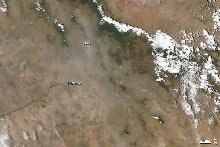
Just before 7:30 p.m. July 5, 2011, a mile-high, roughly 100-mile-wide dust storm roared through Phoenix, Arizona. AZCentral.com reported that the storm was traveling 50 to 60 miles per hour. At the storm’s peak, visibility varied from a quarter of a mile to nothing, and the storm left behind a path of dust and debris.
Faint remnants of the storm remained the next day when the Moderate Resolution Imaging Spectroradiometer (MODIS) on NASA’s Terra satellite captured this natural-color image. The lingering dust plume appears gray-beige, and the thickest dust is concentrated north-northeast of Phoenix.
Between 8:00 and 8:45 p.m. July 5, the Phoenix Sky Harbor International Airport shut down, grounding all planes. Some flights were diverted to Tucson or California for landing. The storm also caused power outages throughout the area, AZCentral.com reported.
The National Weather Service forecast for the evening of July 6 called for a 20 percent chance of thunderstorms and a 20 to 25 percent chance of more dust storms. (EarthObservatory)
 27CDB6E-AE6D-11cf-96B8-444553540000″ codebase=”http://download.macromedia.com/pub/shockwave/cabs/flash/swflash.cab#version=9,0,47,0″>
More Phoenix storms forecast after huge evening dust storm (AZCentral)
Read more:
Doomsday scenario……..Crazy….
My mom lives out there and has told me about these. Crazy!