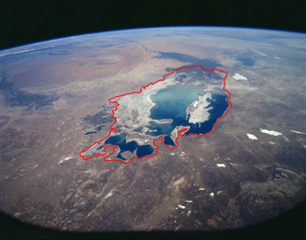
The size of the Aral Sea has long hinged on the Amu Darya, which flows from the high Pamir Mountains in central Asia, across the desert, and into the southern sea. While two rivers empty into the lake—the Amu Darya and the Syr Darya—the Amu Darya is the largest and most fickle source of water. At times in ancient history, the river has bent its course to empty into the Caspian Sea, and the abandoned Aral Sea shrank. The Aral Sea has been at its largest when the Amu Darya feeds it.
Modern trends are no exception: when water began to be diverted from the Amu Darya for vast agricultural projects starting in 1960, the Aral Sea began to shrink.
Between 2000 and 2009, the Aral Sea steadily shrank. In 2006, severe drought settled in over Amu Darya Basin. Very little water reached the Aral Sea in 2007, and nothing flowed from the Amu Darya to the Aral Sea in 2008 and 2009. Without water from the Amu Darya, the southern Aral Sea rapidly dwindled, the eastern lobe all but disappearing in 2009.
In 2010, however, the drought broke. Snow in the Pamir Mountains was normal, and enough water flowed into the Amu Darya that the river reached the Aral Sea. The muddy pulse of water settled in a shallow layer over the bed of the eastern lobe of the South Aral Sea, making it look much larger than it had in 2009.

This Landsat image features the heart-shaped Small Aral Sea (or North Aral Sea), the former northern basin of the Aral Sea that once supported a vibrant economy in Central Asia. (Credit: USGS)
Before 1960, the Aral Sea was the fourth largest lake in the world. However, much of the Amu Darya and Syr Darya have been diverted for agriculture, limiting the flow of water into the sea. Since 1960, the Aral Sea has lost 88 percent of its surface area and 92 percent of its water volume. (OurAmazingPlanet)
Shrinking of the Aral Sea: socio-economic impacts
Water withdrawal and availability in Aral Sea basin
Millions of years ago, the northwestern part of Uzbekistan and western Kazakhstan were covered by a massive inland sea. When the waters receded, they left a remnant sea known as the Aral.
The Aral as an inland salt-water sea has no outlet being fed by the Amu Darya and Syr Darya Rivers. The fresh water from these two rivers once held the Aral’s water and salt levels in balance. However after the 50ies and 60ies when a series of major irrigation schemes were undertaken on the two rivers by Soviet Engineers the water started to recede.
The schemes were based on constructing a series of dams on both two rivers to create reservoirs from which eventially 40.000 km of canals would be dug to divert water to field crops. Afterwards however there was little or no water left in the riverbeds to flow to the Aral Sea. Consequently the water level in the last 50 years in the Aral has dropped by 16 metres (60%) and the volume has been reduced by 75 percent.
Whilst triggering what is considered one of the 20th Centuries greatest ecological disasters; these schemes are however unlikly to be removed as they are the main source of income and food for millions of people in the region.
Related posts:
- Storms worsen Mississippi river flooding While deadly storms raged in the southern and central United States, several rivers continued to spill over their banks in late April 2011, part of ongoing spring flooding in the U.S. and Canada, according to a NASA statement. On April 28 in the afternoon, 62 river gauges reported major flooding, 109 gauges had moderate flooding, 233 gauges showed minor flooding, and 298 showed conditions near flood stage, according to the Advanced Hydrological Prediction Service (AHPS). Flooding was......
- Floods spread south along the Mississippi River The same floods that prompted authorities to breach a levee near Cairo, Illinois, has started forcing residents from their homes farther south along the Mississippi River. On May 6, 2011, the Advanced Hydrological Prediction Service (AHPS) reported that the Mississippi’s water level had reached 46.68 feet (14.23 meters) at Osceola, Arkansas, and 46.14 feet (14.06 meters) at Memphis, Tennessee. At both locations, the Mississippi is in major flood stage and expected to continue rising. The......
- One of the world’s roughest stretches of water Runoff from heavy rains, combined with wave action along the coast, increased the turbidity of New Zealand’s waters when this image was acquired on April 29, 2011, according to a NASA statement. The Moderate Resolution Imaging Spectroradiometer (MODIS) on NASA’s Aqua satellite captured this view of sediment flowing in the Pacific Ocean. The volume of sediment in the water hints at rough seas. Distinctive plumes arise from pulsing rivers, while the halo of turquoise around......
- Iran’s largest lake turning to salt The long popular lake, home to migrating flamingos, pelicans and gulls, has shrunken by 60 percent and could disappear entirely in just a few years, experts say — drained by drought, misguided irrigation policies, development and the damming of rivers that feed it. In April, authorities stopped activities at the nearby jetty in Golmankhaneh harbor, due to lack of water in the lake, now only two meters deep at its deepest. Jetties in Sharafkhaneh......
- Ice loss following the collapse of Antarctic ice shelves An international team of researchers has combined data from multiple sources to provide the clearest account yet of how much glacial ice surges into the sea following the collapse of Antarctic ice shelves. The work by researchers at the University of Maryland, Baltimore County (UMBC), the Laboratoire d’Etudes en Géophysique et Océanographie Spatiales, Centre National de la Recherche Scientifique at the University of Toulouse, France, and the University of Colorado’s National Snow and Ice Data......
- Saharan dust drifts west over Atlantic Ocean A massive Saharan dust plume has drifted west over the Atlantic Ocean and the Cape Verde Islands, located 570 kilometres off the coast of Western Africa. GOES, a US geostationary weather satellite, captured the below image of the dust Friday. The image presents the fine sand particles as a hazy yellow colour (enhanced) that appears below the white clouds. According to the National Oceanic and Atmospheric Administration (NOAA): “Dust storms such as this one are......
- Sandstorm over Iraq A thick dust plume blew over Iraq on June 2, 2011, stopping just short of Iran and Kuwait. The Moderate Resolution Imaging Spectroradiometer (MODIS) on NASA’s Terra satellite captured this natural-color image the same day. The dust forms a giant beige arc that obscures most of Iraq. At least some of the dust storm appears to originate in Syria, where sandy desert sprawls over the landscape on either side of the Euphrates River. Dust also......


MARIO commented on The Watchers:
The big problem for the Aral sea in the sixteenth was the over exploitation on the region to get huge cotton harvests in the view of the Soviet Union, forgetting the nature of this interior sea.
Now the situation is different and the all region is in a economic depression and there is no intensive exploitation, so, the nature can do the work to balance the control of the man on the nature incrising the water supply; Getting the Aral sea into the recovery.
This is a good example to avoid the bad results and to exploit well the resources of the NATURE.
SALUDOS!!!