China prepares for Typhoon Muifa
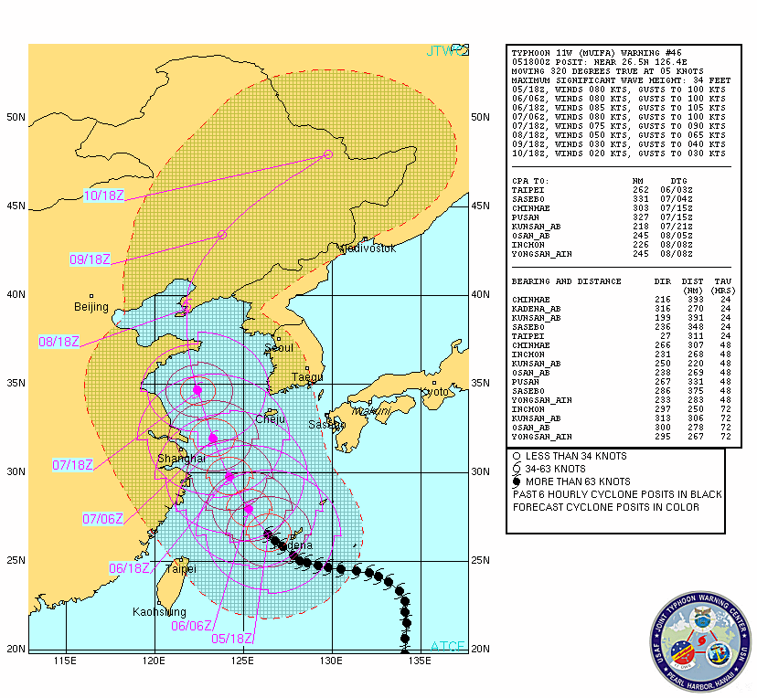
China evacuated more than 200,000 people on its east coast and cancelled nearly 200 flights Friday in preparation for the most powerful typhoon to hit the country in years. Typhoon Muifa, which was packing winds of up to 162 kilometres per hour (100 miles per hour), is expected to make landfall on China’s east coast on Saturday evening or on Sunday, the official Xinhua news agency said.
The eastern province of Zhejiang, located south of Shanghai, had moved to safety just over 206,000 people from its coastal areas in the path of the typhoon by Friday evening, Xinhua said. A weather official in Shanghai told local media the city had “basically ruled out” a direct hit, yet warned it might be close. The typhoon would be the worst to affect China’s commercial centre since 2005, when Typhoon Matsa killed seven people.
China Southern Airlines said it would cancel more than 140 flights to the east of the country from Saturday afternoon while flag carrier Air China said it would cancel more than 30 flights, Xinhua said. Shanghai also warned bullet train services might be slowed or halted because of the storm — a sensitive issue after a deadly high-speed train crash two weeks ago that was initially blamed on weather conditions. China had called more than 9,000 fishing boats back to harbour and cancelled ferry services on more than 20 routes.

China was braced for strong winds and torrential rain. Waves up to 4.5 metres (15 feet) high were expected in coastal areas and up to 12 metres in the East China Sea.

Radar
- Daito-Shima (JMA)
- Okinawa (JMA)
Satellite Imagery
- Storm Region Infrared (MTSAT; FNMOC)
- Storm Region Enhanced Infrared (MTSAT; FNMOC)
- Storm Region Visible (MTSAT; FNMOC)
- Storm-Centered Infrared (MTSAT; NOAA/SSD)
- Storm-Centered Infrared (Aviation Color Enhancement) (MTSAT; NOAA/SSD)
- Storm-Centered Water Vapor (MTSAT; NOAA/SSD)
- Storm-Centered Visible (MTSAT; NOAA/SSD)
- Storm-Centered Water Visible (Colorized) (MTSAT; NOAA/SSD)
- Tropical West Pacific Infrared (MTSAT; NOAA)
- Tropical West Pacific Enhanced Infrared (MTSAT; NOAA)
- Tropical West Pacific Water Vapor (MTSAT; NOAA)
- Tropical West Pacific Visible (MTSAT; NOAA)
Satellite Animations
- Storm-Centered Infrared (MTSAT; NOAA/SSD)
- Storm-Centered Infrared (Aviation Color Enhancement) (MTSAT; NOAA/SSD)
- Storm-Centered Water Vapor (MTSAT; NOAA/SSD)
- Storm-Centered Visible (MTSAT; NOAA/SSD)
- Storm-Centered Visible (Colorized) (MTSAT; NOAA/SSD)
- Tropical West Pacific Infrared (MTSAT; NOAA)
- Tropical West Pacific Enhanced Infrared (MTSAT; NOAA)
- Tropical West Pacific Water Vapor (MTSAT; NOAA)
- Tropical West Pacific Visible (MTSAT; NOAA)

The AccuWeather.com Hurricane Center expects Muifa’s center to remain far enough offshore that its most destructive winds and heaviest rain will narrowly miss Shanghai.
Commenting rules and guidelines
We value the thoughts and opinions of our readers and welcome healthy discussions on our website. In order to maintain a respectful and positive community, we ask that all commenters follow these rules:
We reserve the right to remove any comments that violate these rules. By commenting on our website, you agree to abide by these guidelines. Thank you for helping to create a positive and welcoming environment for all.