Tropical Cyclone Heidi upgraded to Category 2
Tropical Cyclone Heidi has been upgraded to a category two and is expected to reach the Pilbara coast of Western Australia late tonight. This morning Tropical Cyclone Heidi was located roughly 45 nautical miles (85 kilometers) from Port Hedland, Australia. The U.S. Navy’s Joint Typhoon Warning Center (JTWC) reported that Heidi packed maximum sustained winds of 55 knots (100 kilometers per hour) with gusts up to 70 knots (130 kilometers per hour). The storm is moving toward the south-southwest.
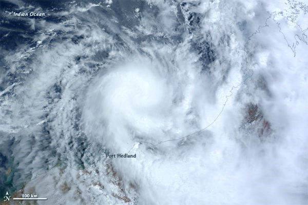
The Moderate Resolution Imaging Spectroradiometer (MODIS) on NASA’s Terra satellite captured this natural-color image on January 11, 2012. The center of the storm is north-northeast of Port Hedland, and storm clouds extended over much of the northwestern Australia coast.

The JTWC forecast that Heidi would make landfall slightly west of Port Hedland. Flooding was expected overnight January 11–12, and that residents of low-lying areas should relocate to emergency shelters. Residents in and near Port Hedland and east to Wallal have been warned of the potential of a dangerous storm tide as the cyclone centre crosses the coast overnight. The Fire and Emergency Service Authority says there is a threat to lives and homes.
The weather bureau says Tropical Cyclone Heidi is estimated to be 115 kilometres north north-east of Port Hedland and 265 kilometres north-east of Karratha. It is moving south south-west at 12km/h towards the coast. Destructive winds with gusts up to 140km/h are possible overnight between Whim Creek and Pardoo, including Port Hedland, the bureau says. Gales with gusts to 100km/h may also extend west to Dampier overnight and in the adjacent parts of the central Pilbara.
The weather bureau says very heavy rainfall is expected overnight in the river catchments between Port Hedland and Karratha. Up to 250mm of rain is possible across central and eastern Pilbara over the next few days, with isolated heavier falls near the coast, the bureau says.
Featured image: The Moderate Resolution Imaging Spectroradiometer (MODIS) on NASA’s Terra satellite captured this natural-color image on January 11, 2012. The center of the storm is north-northeast of Port Hedland, and storm clouds extended over much of the northwestern Australia coast. (NASA image courtesy Jeff Schmaltz, LANCE/EOSDIS MODIS Rapid Response Team at NASA GSFC. Caption by Michon Scott.)
Commenting rules and guidelines
We value the thoughts and opinions of our readers and welcome healthy discussions on our website. In order to maintain a respectful and positive community, we ask that all commenters follow these rules.