M 6.0 earthquake near the east coast of Honshu, Japan
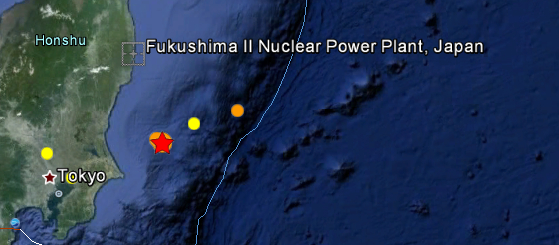
USGS reported magnitude 6.0 earthquake with depth of 10 km at 06:21 (UTC, Feb. 14, 2012) near the east coast of Honshu, Japan. Epicenter was 70 km of the coast, 165 km of Tokyo, 136 km of Fukushima nuclear plant. Earthquake-report.com calls it moderately dangerous earthquake. No tsunami warning was issued. EMSC reported this as 5.6 magnitude earthquake. Three hours earlier, at 03:27 (UTC), the same region was hit by M5.4 earthquake with depth of 9.3 km.
| Magnitude | 6.0 |
|---|---|
| Date-Time |
|
| Location | 36.154°N, 141.494°E |
| Depth | 10 km (6.2 miles) |
| Region | NEAR THE EAST COAST OF HONSHU, JAPAN |
| Distances | 93 km (57 miles) ESE of Mito, Honshu, Japan 113 km (70 miles) SSE of Iwaki, Honshu, Japan 151 km (93 miles) ESE of Utsunomiya, Honshu, Japan 165 km (102 miles) ENE of TOKYO, Japan |
| Location Uncertainty | horizontal +/- 14.1 km (8.8 miles); depth +/- 2.8 km (1.7 miles) |
| Parameters | NST=298, Nph=300, Dmin=298.3 km, Rmss=0.97 sec, Gp=101°, M-type=regional moment magnitude (Mw), Version=8 |
| Source |
|
Historic seismicity map (2012)

Featured image: Google Earth + Real time earthquakes (USGS)
Commenting rules and guidelines
We value the thoughts and opinions of our readers and welcome healthy discussions on our website. In order to maintain a respectful and positive community, we ask that all commenters follow these rules:
We reserve the right to remove any comments that violate these rules. By commenting on our website, you agree to abide by these guidelines. Thank you for helping to create a positive and welcoming environment for all.