Australian floods: scope of flooding coming to light – state of emergency for Wagga Wagga
Floodwaters covering much of western New South Wales, northern Victoria and northern South Australia are now glaring in the sunshine after a week’s worth of dense cloud and rain.
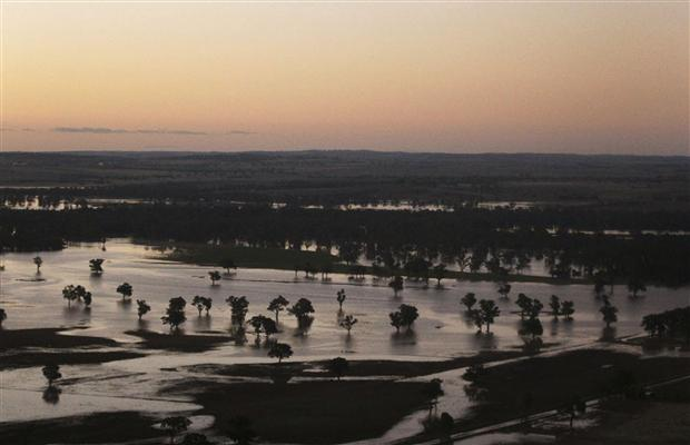
The scope of the flooding is coming to light, particularly from the air, where floodwaters are reflecting blue sky for thousands of kilometres, much of it across the Murray-Darling Catchment. Flood levels across the catchment are expected to reach those of the 1970s or 1950s.
On the ground and in the water, where residents, emergency services and volunteers continue to shepherd people and livestock away from swollen rivers, the brightness is akin to sailing on the ocean. Hats, longsleeves and sunblock are now part of the uniform due to the very high UV index.
Mosquitoes are often a concern after a flood event, but thankfully they have not become a major problem yet. The one thing keeping the mozzies at bay is cooler southerly winds which are filtering across the region. These winds are reducing the humidity and keeping temperatures a few degrees below average, conditions which keep their breeding down.
One of the worst affected areas, in terms of widespread flooding, has been in the Murray-Darling Catchment of NSW and Victoria. Some of the often-dry floodplains have been subject to serious flooding, a result of the wettest week on record.
Parts of the Upper Western, Lower Western, Riverina, South West Slopes, Southern Tablelands and North East districts have had their wettest week in at least 100 years of records.
Grong Grong gained 369mm, Burrinjuck Dam 329mm, Yackandandah 324mm, Ivanhoe 294mm, Coolamon 274mm, Rutherglen 261mm, Lake Cargelligo 244mm and Wilcannia 240mm, all of which are new 100-year records for weekly rain totals.
Now that the rain has stopped and cooler, drier southerly winds are taking over it’s a matter of staying clear from floodwaters until they recede enough to start the clean-up. On the flattest terrain the receding will take weeks. Thankfully there looks like being at least a week of dry weather to clean up.
For those downstream, including in South Australia’s Murray region, a new surge of water is on its way, which may also lead to significant flooding in the coming weeks. The flushing out of the river system will reach the Lower Lakes near Goolwa, much like what happened early last year.
Meanwhile, the once-oscillating trough which brought this week-long drenching has moved well to the northeast. It has taken rain cloud to northeastern New South Wales and southeast Queensland, where showers and storms are not nearly as heavy. (www.weatherwatch.co.nz)
State of emergency for flood ravaged Wagga Wagga

On March 6th, 2012 an urgent evacuation order has been issued for Wagga Wagga in southern New South Wales, with residents being told to leave their homes by 6am AEDT on Tuesday.
The State Emergency Service says if the Murrumbidgee River reaches an expected peak of 10.9 metres on Tuesday morning, the levee will be breached and the town’s centre flooded. Region Controller James McTavish said everyone in central Wagga Wagga must get out.
NSW Premier Barry O’Farrell has declared a state of emergency for flood ravaged Wagga Wagga. O’Farrell visited the south-western NSW town today. He announced on his return to Sydney that following a recommendation from the Natural Disaster Council he had declared a state emergency in what is the state’s largest inland city. About 9000 people have been evacuated from Wagga Wagga with fears the flood levee, the city’s last line of defence, will be breached by the Murrumbidgee River later today. The river, which cuts through NSW’s largest inland city, is due to peak at 10.90 metres – its highest peak since 1853 – at 3pm (6pm NZT) today. At 11am the SES said the water level was at 10.3 metres and about 8810 people had been forced to leave their homes.
The levee height is 11 metres but there are concern about its ability to hold once it hits 10.6 metres. “So anything above 10.6 metres … the risk of potential failure of that levee increases and that is what we’re planning for,” NSW assistant police commissioner Mark Murdoch told reporters in Sydney. Asked about the potential damage should the levee break, Murdoch replied: “We’re in unchartered water in that respect”. “If the levee is breached we would expect significant inundation and expect that to happen very, very quickly.” The town’s CBD will suffer major flooding if this happens and hundreds of homes are in danger of being inundated. “Since my return, following discussions with the minister for police and emergency services, the government’s determined to declare a state of emergency for Wagga Wagga to ensure that the state emergency service and the other emergency service organisations involved have the maximum set of tools available for them to protect life and property,” O’Farrell told parliament. “That decision is based on the continuing concern that flood waters are rising and could spill over the levee or cause the levee to breach later this evening. “My advice .. is if the levee is breached it may not possible for people to return to town for approximately three days.” The emergency declaration would be rescinded on Wednesday morning if the levee was not breached, O’Farrell said.

Earlier today O’Farrell backed the establishment of a New Zealand-style natural disaster fund to help pay for the damage caused by flooding. The current bill for repairing roads damaged by inundations is estimated to stand at half a billion dollars so far. “I do support that New Zealand-style national disaster fund,” O’Farrell told Macquarie Radio Network. “Clearly these are efforts that are required to go beyond any single service, any single state and it requires a national response.” New Zealand has run a multi-billion dollar national disaster fund, the Earthquake Commission, since 1945, with premiums taken from insurance policies. The fund provides cover for various natural disasters. There is currently around $5.6 billion in the fund which is backed up by reinsurance from overseas groups and a Government Guarantee. O’Farrell said it will take more than half a billion dollars to repair flood-damaged NSW roads alone. Across the state more than 13,000 people have been ordered from their homes because of flooding, including 560 in Forbes. Pearce said there was also major flooding in western NSW, with over 2500 inundated by floodwaters.
“We are doing really significant resupply missions out there as well,” he said. Speaking to reporters in Wagga Wagga, O’Farrell said the view of the north of the town from the air revealed “a sad and sorry picture, with homes inundated”. “This is devastating for small business operators; it’s devastating for farmers; it’s devastating for those whose houses are flooded,” he said. O’Farrell said it was too early to count the damage bill, but said flooding throughout NSW in previous months would cost the state and local councils half-a-billion dollars in road repairs. “That’s $500 million that neither state nor local governments have budgeted for,” O’Farrell said. The state’s Treasurer Mike Baird has warned the flood crisis will affect the state budget – but says it is too early to put a figure on it. He has told Fairfax it is not just the massive cost of emergency assistance and fixing infrastructure but also the hit to small business owners and primary producers that will hurt the state economy.
Gympie businesses are closed as the flood-weary Queensland city braces for its second flood in three weeks. Gympie Mayor Ron Dyne says residents are waiting anxiously to see how high the Mary River rises. On current forecasts a handful of businesses are expected to flood as the river inches towards an expected peak on Tuesday night. “We have a very good flood plan in position here. We’ve unfortunately been practised a number of times with this Mary River and the way it floods,” he said today. Businesses prone to flooding have been evacuated, Gympie Chamber of Commerce president Ben Ellingsen said. “Each of the businesses by now know that when the river reaches a certain level they’ve got to get out,” he said. One business was flooded in the big wet a few weeks ago. It only reopened last week and was closed again by Monday. “People are just annoyed that they’ve got to keep re-establishing and dismantling businesses,” Dyne said. “This is just an added cost.” Australian Bureau of Meteorology senior hydrologist Paul Birch said a moderate flood peak was due to come through Gympie tonight. “We are looking at rises of up to about 15 metres at Gympie this evening,” he said. Ellingsen said a 16-17 metre peak would threaten Gympie’s main street.
Floodwaters are receding in most of Victoria’s northeast, and federal relief funding is on its way. SES spokesman Lachlan Quick said most of the region’s floodwaters were slowly retreating, apart from at Nathalia, where they were expected to peak on Wednesday or Thursday. As crews built an emergency levee bank to protect 172 homes and the Nathalia hospital today, about 400 residents were told at a meeting the floodwaters were expected to peak at about 3.1 metres. This is higher than 1993 flood levels in the town, but lower than the 3.35 metres previously forecast. Premier Ted Baillieu said he hoped the levee banks would protect the town. “At Nathalia the levee banks are still to be completed there, and that’ll be completed today and we hope those levee banks hold,” Baillieu told reporters in Melbourne. Shepparton Incident Control Centre spokesman Darren Skelton said people at the Nathalia town meeting were calm and cooperative. “They’ve planned well for the event, and the level of cooperation between volunteers, SES, CFA, Victoria Police, means they’ve managed to do a significant amount of work to prepare,” Skelton said. Visiting flood-affected Shepparton today, federal Emergency Management Minister Nicola Roxon said flooded communities would receive emergency funding. “In some areas it could be weeks before floodwaters recede and proper impact assessments can be made,” Roxon said.
“This assistance package will provide a much-needed helping hand to families and businesses and provide funds to ensure damaged public infrastructure is restored as quickly as possible.” The Natural Disaster Relief and Recovery Arrangements funding will be available to people in the shires of Greater Shepparton, Greater Bendigo, Mount Alexander and Indigo, as well as in flooded areas of NSW. With a number of communities isolated by the widespread flooding along the flat farming region of northeast Victoria, Baillieu said it would take some time to see the extent of the damage. “It will take a while. There are a lot of roads that are flooded that are inaccessible and impassable at the moment,” Baillieu said. “The water has to pass and subside so the assessment of the roads can be done. “This is a major event and, as I said earlier, it’s disguised somewhat because the skies are clear … but this event is going to go on for some time.” Baillieu warned people not to enter the floodwaters around the region, after a 43-year-old Victorian man was swept away and died after trying to drive through NSW floodwaters on Saturday. (RSOE-EDIS)
Update: Wednesday March 7, 2012 at 01:41 EDT (local time) – Floodwaters in the New South Wales town of Wagga Wagga have peaked below the levy protecting the town, but authorities are warning the crisis is not over yet.
The New South Wales State Emergency Service says an evacuation order will stay in place in Wagga Wagga in the state’s south-west overnight, even though the waters have dropped slightly.
The Murrumbidgee River peaked lower than expected, but emergency workers will continue to monitor the town’s levee to make sure it holds steady.
Thousands of residents spent a second night in evacuation centres, and will be hoping to return now the waters have begun to drop, but James McTavish from the SES says they will not be able to send locals home until engineering surveys have been completed. (http://www.weatherzone.com.au/news/)
Severe Flooding in Southeastern Queensland – Heaviest Rain in Victoria Since 1893

Featured image credit: desdemonadespair.net
Wow! 🙁