Active volcanoes in the world – April 4 – April 10, 2012
This report covers active volcanoes recorded from April 4 – April 10, 2012 based on Smithsonian/USGS criteria. New unrest has been noticed around 4 volcanoes, ongoing activity was reported for 9 volcanoes.
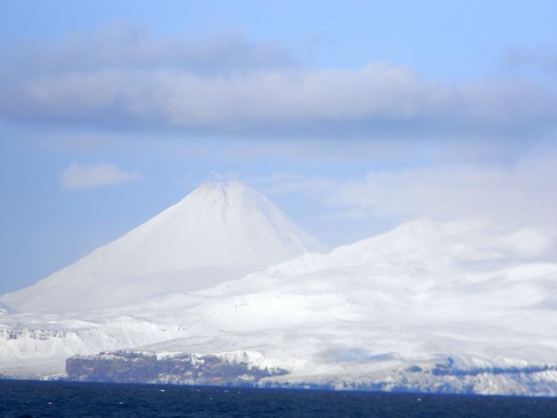
CLEVELAND
Chuginadak Island 52.825°N, 169.944°W; summit elev. 1730 m
AVO reported that a small explosion from Cleveland was detected at 0112 on 4 April by distant seismic stations and infrasound arrays. Weather conditions prevented the detection of a possible eruption cloud in satellite images or by visual observation of the summit. Observations the next day revealed a thermal anomaly and that the 70-m-diameter lava dome had been destroyed by the explosion. This was the third lava dome that was erupted and subsequently destroyed by explosive events since the eruption began in July 2011.
On 6 April two short-duration explosions occurred at about 1635 and 2126. The resulting eruption clouds were ashpoor and did not rise above 3 km (10,000 ft) a.s.l. Elevated surface temperatures were observed using infrared satellite images near the times of the explosions. Satellite observations were obscured by clouds during 8-10 April. No seismic information was available because Cleveland does not have a real-time seismic network.
Geologic summary: Symmetrical Mount Cleveland stratovolcano is situated at the western end of the uninhabited dumbbell-shaped Chuginadak Island in the east-central Aleutians. The 1,730-m-high stratovolcano is the highest of the Islands of Four Mountains group and is one of the most active in the Aleutians. Numerous large lava flows descend its flanks. It is possible that some 18th to 19th century eruptions attributed to Carlisle (a volcano located across the Carlisle Pass Strait to the NW) should be ascribed to Cleveland. In 1944 Cleveland produced the only known fatality from an Aleutian eruption. Recent eruptions from Mt. Cleveland have been characterized by short-lived explosive ash emissions, at times accompanied by lava fountaining and lava flows down the flanks.
FUEGO
Guatemala 14.473°N, 90.880°W; summit elev. 3763 m
INSIVUMEH reported that during 9-10 April explosions from Fuego produced ash plumes that rose 100-900 m above the crater and drifted 10-15 km E and SE. Explosions produced shock waves detected within 8 km of the volcano. Avalanches descended the flanks.
Geologic summary: Volcán Fuego, one of Central America’s most active volcanoes, is one of three largestratovolcanoes overlooking Guatemala’s former capital, Antigua. The scarp of an older edifice, Meseta, lies between 3,763-m-high Fuego and its twin volcano to the N, Acatenango. Construction of Meseta volcano continued until the late Pleistocene or early Holocene, after which growth of the modern Fuego volcano continued the southward migration of volcanism that began at Acatenango. Frequent vigorous historical eruptions have been recorded at Fuego since the onset of the Spanish era in 1524, and have produced major ashfalls, along with occasional pyroclastic flows and lava flows. The last major explosive eruption from Fuego took place in 1974, producing spectacular pyroclastic flows visible from Antigua.
NEVADO DEL RUIZ
Colombia 4.895°N, 75.322°W; summit elev. 5321 m
According to INGEOMINAS, the Observatorio Vulcanológico and Sismológico de Manizales reported that during 4-10 April seismicity at Nevado del Ruiz fluctuated but remained elevated. Sulfur dioxide emissions also remained high; occasionally a sulfur odor was reported in Manizales, about 25 km NW. On 5 April a volcano-tectonic earthquake, M 2.8, occurred below Arenas crater at a depth of 1 km, and was the highest magnitude earthquake recorded since February. During 4-6 April gas-and-steam plumes drifted NW. Gas-and-steam plumes rose 3 km above the crater on 7 April and 1.5 km above the crater on 10 April; the plumes drifted SE both days. The Alert Level remained at II (Orange; “eruption likely within days or weeks”).
Geologic summary: Nevado del Ruiz is a broad, glacier-covered volcano in central Colombia that covers >200 sq km. Three major edifices, composed of andesitic and dacitic lavas and andesitic pyroclastics, have been constructed since the beginning of the Pleistocene. The modern cone consists of a broad cluster of lava domes built within the summit caldera of an older Ruiz volcano. The 1-km-wide, 240-m-deep Arenas crater occupies the summit. Steep headwalls of massive landslides cut the flanks of Nevado del Ruiz. Melting of its summit icecap during historical eruptions, which date back to the 16th century, has resulted in devastating lahars, including one in 1985 that was South America’s deadliest eruption.
SOUFRIERE HILLS
Montserrat 16.72°N, 62.18°W; summit elev. 915 m
MVO reported that during 30 March-6 April activity at the Soufrière Hills lava dome was generally at a low level and no ash-venting episodes had been detected since 23 March. The average sulfur dioxide emission rate measured during the week was 529 tonnes per day with a minimum of 200 and a maximum of 1,033. Scientists aboard a helicopter overflight on 4 April observed a new vent which had formed on 23 March; it was 30-50 m across and on the W side of the crater floor. The Hazard Level remained at 2.
Geologic summary: The complex dominantly andesitic Soufrière Hills volcano occupies the southern half of the island of Montserrat. The summit area consists primarily of a series of lava domes emplaced along an ESE-trending zone. English’s Crater, a 1-km-wide crater breached widely to the E, was formed during an eruption about 4,000 years ago in which the summit collapsed, producing a large submarine debris avalanche. Block-and-ash flow and surge deposits associated with dome growth predominate in flank deposits at Soufrière Hills. Non-eruptive seismic swarms occurred at 30-year intervals in the 20th century, but with the exception of a 17th-century eruption that produced the Castle Peak lava dome, no historical eruptions were recorded on Montserrat until 1995. Long-term small-to-moderate ash eruptions beginning in that year were later accompanied by lava-dome growth andpyroclastic flows that forced evacuation of the southern half of the island and ultimately destroyed the capital city of Plymouth, causing major social and economic disruption.
Ongoing activity
KARYMSKY
Eastern Kamchatka (Russia) 54.05°N, 159.45°E; summit elev. 1536 m
KVERT reported that during 30 March-6 April moderate seismic activity from Karymsky continued to be detected, and indicated that possible ash plumes rose to an altitude of 2.5 km (8,200 ft) a.s.l. Satellite imagery showed a thermal anomaly on the volcano on 29 March. The Aviation Color Code remained at Orange.
Geologic summary: Karymsky, the most active volcano of Kamchatka’s eastern volcanic zone, is a symmetricalstratovolcano constructed within a 5-km-wide caldera that formed about 7,600-7,700 radiocarbon years ago. Construction of the Karymsky stratovolcano began about 2,000 years later. The latest eruptive period began about 500 years ago, following a 2,300-year quiescence. Much of the cone is mantled by lava flows less than 200 years old. Historical eruptions have been Vulcanian or Vulcanian-Strombolian with moderate explosive activity and occasional lava flows from the summit crater. Most seismicity preceding Karymsky eruptions has originated beneath Akademia Nauk caldera, which is located immediately S of Karymsky volcano and erupted simultaneously with Karymsky in 1996.
KILAUEA
Hawaii (USA) 19.421°N, 155.287°W; summit elev. 1222 m
During 4-10 April HVO reported that the circulating lava lake periodically rose and fell in the deep pit within Kilauea’s Halema’uma’u Crater. Almost daily measurements indicated that the gas plume from the vent continued to deposit variable amounts of ash, and occasionally fresh spatter, nearby. Incandescence was visible from both a lava pond in a small pit on the E edge and a small spatter cone on the SE edge of the Pu’u ‘O’o crater floor, and on the upper part of the lava-tube system on the E flank. Lava flows continued to advance down the pali and across the coastal plain, reaching about 1.6 km from the coast. During 6-9 April a small lava flow issued three times from a vent on the SE edge of the Pu’u ‘O’o crater floor. The first two flows advanced N almost the entire width of the floor.
Geologic summary: Kilauea, one of five coalescing volcanoes that comprise the island of Hawaii, is one of the world’s most active volcanoes. Eruptions at Kilauea originate primarily from the summit caldera or along one of the lengthy E and SW rift zones that extend from the caldera to the sea. About 90% of the surface of Kilauea is formed of lava flows less than about 1,100 years old; 70% of the volcano’s surface is younger than 600 years. A long-term eruption from the East rift zone that began in 1983 has produced lava flows covering more than 100 sq km, destroying nearly 200 houses and adding new coastline to the island.
PAGAN
Mariana Islands 18.13°N, 145.80°E; summit elev. 570 m
Clear-to-partly-cloudy satellite images of Pagan showed a gas-and-steam plume extending downwind from the summit vent during 30 March-6 April. The Aviation Color Code remained at Yellow and the Volcano Alert Level remained at Advisory. According to the Washington VAAC a pilot observed a plume containing a small amount ofash that rose to an altitude below 1.5 km (5,000 ft) a.s.l. on 7 April. Satellite imagery showed a gas-and-steam plume, with possible ash content, drifting 204 km SSW.
Geologic summary: Pagan Island, the largest and one of the most active of the Mariana Islands volcanoes, consists of two stratovolcanoes connected by a narrow isthmus. Both North and South Pagan stratovolcanoes were constructed within calderas, 7 and 4 km in diameter, respectively. The 570-m-high Mount Pagan at the NE end of the island rises above the flat floor of the caldera, which probably formed during the early Holocene. South Pagan is a 548-m-high stratovolcano with an elongated summit containing four distinct craters. Almost all of the historicaleruptions of Pagan, which date back to the 17th century, have originated from North Pagan volcano. The largest eruption of Pagan during historical time took place in 1981 and prompted the evacuation of the sparsely populated island.
PUYEHUE-CORDON CAULLE
Central Chile 40.590°S, 72.117°W; summit elev. 2236 m
OVDAS–SERNAGEOMIN reported that during 9-10 April satellite and web camera observations of the Cordón Caulle rift zone, part of the Puyehue-Cordón Caulle volcanic complex, showed plumes that rose no higher than 450 m above the crater. Incandescence from the crater was also observed. The Alert Level remained at Orange.
Geologic summary: The Puyehue-Cordón Caulle volcanic complex (PCCVC) is a large NW-SE-trending late-Pleistocene to Holocene basaltic-to-rhyolitic transverse volcanic chain SE of Lago Ranco. The 1799-m-highPleistocene Cordillera Nevada caldera lies at the NW end, separated from Puyehue stratovolcano at the SE end by the Cordón Caulle fissure complex. The Pleistocene Mencheca volcano with Holocene flank cones lies NE of Puyehue. The basaltic-to-rhyolitic Puyehue volcano is the most geochemically diverse of the PCCVC. The flat-topped, 2236-m-high Puyehue volcano was constructed above a 5-km-wide caldera and is capped by a 2.4-km-wide summit caldera of Holocene age. Lava flows and domes of mostly rhyolitic composition are found on the eastern flank of Puyehue. Historical eruptions originally attributed to Puyehue, including major eruptions in 1921-22 and 1960, are now known to be from the Cordón Caulle rift zone. The Cordón Caulle geothermal area, occupying a 6 x 13 km wide volcano-tectonic depression, is the largest active geothermal area of the southern Andes volcanic zone.
RANAKAH
Flores Island (Indonesia) 8.62°S, 120.52°E; summit elev. 2350 m
CVGHM reported that during January-8 April white plumes rose 10-15 m above the Anak Ranakah lava dome and seismicity decreased. On 9 April the Alert Level was lowered to 1 (on a scale of 1-4).
Geologic summary: A new lava dome, named Anak Ranakah (Child of Ranakah) was formed in 1987 in an area without previous historical eruptions at the base of the large older lava dome of Gunung Ranakah. An arcuate group of lava domes extending westward from Gunung Ranakah occurs on the outer flanks of the poorly known Poco Leokcaldera on western Flores Island. Pocok Mandosawa lava dome, at 2350 m the highest point on the island of Flores, lies west of Anak Ranakah.
SANTA MARIA
Guatemala 14.756°N, 91.552°W; summit elev. 3772 m
Based on analyses of satellite imagery and reports from INSIVUMEH, the Washington VAAC reported that on 7 April multiple ash clouds from explosions at Santa María drifted 37 km SW and 11 km S. INSIVUMEH reported that during 8-10 April explosions from Caliente dome generated ash plumes that rose 600-900 m above the dome and drifted 15 km S and SW. Lava flows continued to produce avalanches that descended the flanks.
Geologic summary: Symmetrical, forest-covered Santa María volcano is one of a chain of large stratovolcanoesthat rises dramatically above the Pacific coastal plain of Guatemala. The stratovolcano has a sharp-topped, conical profile that is cut on the SW flank by a large, 1-km-wide crater, which formed during a catastrophic eruption in 1902 and extends from just below the summit to the lower flank. The renowned Plinian eruption of 1902 followed a long repose period and devastated much of SW Guatemala. The large dacitic Santiaguito lava-dome complex has been growing at the base of the 1902 crater since 1922. Compound dome growth at Santiaguito has occurred episodically from four westward-younging vents, accompanied by almost continuous minor explosions and periodiclava extrusion, larger explosions, pyroclastic flows, and lahars.
SHIVELUCH
Central Kamchatka (Russia) 56.653°N, 161.360°E; summit elev. 3283 m
KVERT reported that explosive activity at Shiveluch continued during 29 March-6 April. Ground-based observers and satellite imagery indicated that a viscous lava flow continued to effuse in the crater formed during a 2010 eruption. Visual observations revealed that ash plumes rose to an altitude of 4 km (13,100 ft) a.s.l. on 30 March and 3 April. Seismic data indicated that ash plumes potentially rose to an altitude of 6.6 km (21,600 ft) a.s.l. every day. Satellite imagery showed a weak thermal anomaly on the lava dome during 29-31 March and 3 April, and ash plumes that drifted 114 km W, E, and NE during 29-30 March and 3 April. The Aviation Color Code remained at Orange.
Geologic summary: The high, isolated massif of Shiveluch volcano (also spelled Sheveluch) rises above the lowlands NNE of the Kliuchevskaya volcano group and forms one of Kamchatka’s largest and most active volcanoes. The currently active Molodoy Shiveluch lava-dome complex was constructed during the Holocene within a large breached caldera formed by collapse of the massive late-Pleistocene Strary Shiveluch volcano. At least 60 large eruptions of Shiveluch have occurred during the Holocene, making it the most vigorous andesitic volcano of the Kuril-Kamchatka arc. Frequent collapses of lava-dome complexes, most recently in 1964, have produced large debris avalanches whose deposits cover much of the floor of the breached caldera. Intermittent explosive eruptions began in the 1990s from a new lava dome that began growing in 1980. The largest historical eruptions from Shiveluch occurred in 1854 and 1964.
TAMBORA
Sumbawa Island (Indonesia) 8.25°S, 118.00°E; summit elev. 2850 m
CVGHM reported that during January-8 April plumes did not rise from Tambora, no changes were observed around the caldera, and seismicity decreased. On 9 April the Alert Level was lowered to 1 (on a scale of 1-4).
Geologic summary: The massive Tambora stratovolcano forms the entire 60-km-wide Sanggar Peninsula on northern Sumbawa Island. The largely trachybasaltic-to-trachyandesitic volcano grew to about 4000 m elevation before forming a caldera more than 43,000 years ago. Late-Pleistocene lava flows largely filled the early caldera, after which activity changed to dominantly explosive eruptions during the early Holocene. Tambora was the source of history’s largest explosive eruption, in April 1815. Pyroclastic flows reached the sea on all sides of the peninsula, and heavy tephra fall devastated croplands, causing an estimated 60,000 fatalities. The eruption of an estimated more than 150 cu km of tephra formed a 6-km-wide, 1250-m-deep caldera and produced global climatic effects. Minor lava domes and flows have been extruded on the caldera floor at Tambora during the 19th and 20th centuries.
TUNGURAHUA
Ecuador 1.467°S, 78.442°W; summit elev. 5023 m
IG reported that during 4-8 April visual observations of Tungurahua were limited due to cloud cover. During 9-10 April ash-and-steam plumes rose 2-3 km above the crater and drifted from NE to SE. Explosions were heard in areas near the volcano. Ashfall was reported in Capil, Palictahua, and Los Toctes on 9 April. Lahars descended the W flank on 10 April and caused the road between Baños and Penipe to close.
Geologic summary: The steep-sided Tungurahua stratovolcano towers more than 3 km above its northern base. It sits ~140 km S of Quito, Ecuador’s capital city, and is one of Ecuador’s most active volcanoes. Historical eruptions have all originated from the summit crater. They have been accompanied by strong explosions and sometimes bypyroclastic flows and lava flows that reached populated areas at the volcano’s base. The last major eruption took place from 1916 to 1918, although minor activity continued until 1925. The latest eruption began in October 1999 and prompted temporary evacuation of the town of Baños on the N side of the volcano.
Source: Global Volcanism Program
Featured image: Photo of Mt Cleveland taken at 18:00 GMT on 11 Mar 2012 by Lt. Matthew Davis aboard the NOAA ship Oscar Dyson. Photo taken while transiting north through Samalga pass while on fisheries survey. Several small explosions were detected in several days prior to the time of the photo, but very little ash is observed on the upper flanks. Creator: Davis, Matthew. Image courtesy of NOAA.
Commenting rules and guidelines
We value the thoughts and opinions of our readers and welcome healthy discussions on our website. In order to maintain a respectful and positive community, we ask that all commenters follow these rules:
We reserve the right to remove any comments that violate these rules. By commenting on our website, you agree to abide by these guidelines. Thank you for helping to create a positive and welcoming environment for all.