Extreme weather in US: tennis ball sized hail in Nebraska and stunning multi-vortex tornado near Woodward, western Oklahoma
A devastating string of severe thunderstorms and tornadoes was tracked through Texas, Oklahoma, Kansas, and Nebraska on Saturday, April 14, 2012.
This severe weather outbreak was remarkable in its duration as supercell thunderstorms began to pop up in western Kansas late Saturday morning and the dry line that was supposed to represent the end of the severe weather threat was only halfway through Kansas, Oklahoma, and Texas by 1:00 AM Central Time Sunday.
A dry line is a boundary that separates warm, moist air from dry desert air.
Multi-vortex tornado
The SPC storm reports show the typical track of these storms, with Kansas being the hardest hit. Early in the afternoon, most of the supercell thunderstorms were consistently producing weak tornadoes that skipped across western and central Kansas. As the low-level jet kicked in late in the afternoon and into the evening, these thunderstorm strengthened considerably.
Probably the most remarkable supercell thunderstorm began in western Oklahoma near Woodward as a stunning multi-vortex tornado. The tornado actually was several tornadoes that danced into southern Kansas and eventually threatened Wichita. While it did pass south and east of the city, it did produce an 84 mph (135 kmh)wind gust at the Wichita Airport. It also did extensive damage at the airport.
In addition, the Oaklawn area of Wichita was declared a disaster area very soon after the tornado passed. The Sedgwick County commissioner declared the county a disaster area with a couple hours of the devastating tornado’s passage. This wedge tornado eventually moved along the Kansas Turnpike northeast of Wichita before it finally dissipated.
The scariest tornado struck Woodward, OK early Sunday morning (April 15, 2012) as the main squall line moved through western Oklahoma. This tornado was very large and particularly dangerous since it occurred at night when most residents assumed the threat had ended. There were multiple reports of not hearing the city’s siren, so it is entirely possible that the siren was either struck by lightning or hit by the tornado itself. There was reported widespread damage in Woodward along with several injuries.
Perhaps the most telling feature of this severe weather outbreak was its repetitive nature. Salina, KS was tornado warned three times by three separate severe thunderstorms. Similarily, areas from Medicine Lodge to Kingman, Kansas were warned for two separate thunderstorms, while Woodward itself was warned very early in the day before a different tornado moved through the city late in the night.
The good news is that as the as the dry line and associated thunderstorms continue moving east, the severe threat will lessen.
The National Weather Service’s Wichita office, taking part in an experimental warning system, used graphic terms to warn residents of potential harm. The warnings are used by media outlets. Residents near Brookville, Kansas, for example, were told “major house and building damage was likely and complete destruction was possible.” Des Moines, Iowa, National Weather Service meteorologist Roger Vachalek said residents in the area should be prepared for high winds and possible tornadoes and hail overnight. Two or three possible tornadoes were already sighted. About 16,000 MidAmerican Energy customers in the Des Moines area lost power. At least four apparent tornadoes were reported near Dodge City, in southwestern Kansas, officials said. Two were reported in Rush County. “It’s been an interesting day,” said meteorologist Mike Scott, adding severe storms arrived earlier than expected. Forecasters said a “dry line” colliding with moist Gulf air was making for dangerous conditions.
Tennis ball sized hail
Tennis-ball-sized hail and winds of up to 60 miles per hour (96 kmh) were reported in Nebraska’s Antelope and Boone counties, said Mike Moritz of the National Weather Service office in Hastings, Nebraska. Tornado reports came in from Hardy and Deshler, Nebraska, and Tipton, Kansas. None was a long-track tornado. Rick Smith, warning coordination meteorologist in the agency’s Norman, Oklahoma, office, said a line of supercell thunderstorms stretched Saturday afternoon from northwestern Oklahoma to the Texas Panhandle.

No injuries had been reported in Oklahoma by mid-evening Saturday. According to CNN meteorologist Sean Morris, “high risk” areas could possibly endure EF3 to EF5 tornadoes, packing winds of 136 mph (218 kmh) or stronger. CNN meteorologist Dave Hennen said the Interstate 35 corridor — from Oklahoma City to Wichita — was among the most threatened areas. An elevated severe thunderstorm “moderate” threat extended from northern Nebraska, southward into the tip of northern Texas. This includes Tulsa, Oklahoma, and Kansas City, Missouri. A “slight” risk area extended all the way from Texas to southwestern Wisconsin.
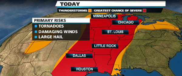
Sunday’s Threat – Severe weather chances stretch from Texas to the upper-Mississippi Valley and Great Lakes.

Sources: WorldWeatherPost, RSOE, Weather.com
Featured image: weather.com
Commenting rules and guidelines
We value the thoughts and opinions of our readers and welcome healthy discussions on our website. In order to maintain a respectful and positive community, we ask that all commenters follow these rules:
We reserve the right to remove any comments that violate these rules. By commenting on our website, you agree to abide by these guidelines. Thank you for helping to create a positive and welcoming environment for all.