Strong and deep M6.4 earthquake struck Tonga region
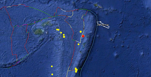
Strong and deep earthquake with magnitude 6.4 struck Tonga region on April 28, 2012. Epicenter was located 78 km (48 miles) W of Neiafu, Tonga (18.643°S, 174.725°W). Recorded depth was 129.4 km (80.4 miles) by USGS.
Earthquake was harmless for shaking damage and tsunami as the depth and source of earthquake is unable to generate strong shaking or tsunami waves. Additionaly, the people living in this region are familiar with strong shaking.
| Magnitude | 6.7 |
|---|---|
| Date-Time |
|
| Location | 18.643°S, 174.725°W |
| Depth | 129.4 km (80.4 miles) |
| Region | TONGA |
| Distances | 78 km (48 miles) W of Neiafu, Tonga 280 km (173 miles) N of NUKU`ALOFA, Tonga 315 km (195 miles) SSW of Hihifo, Tonga 2266 km (1408 miles) NNE of Auckland, New Zealand |
| Location Uncertainty | horizontal +/- 15 km (9.3 miles); depth +/- 4.6 km (2.9 miles) |
| Parameters | NST=454, Nph=457, Dmin=611.1 km, Rmss=0.81 sec, Gp= 22°, M-type=centroid moment magnitude (Mw), Version=9 |
| Source |
|
| Event ID | usc0009e33 |

Historical seismicity – M7 and greater since 1900

Featured image: Google Earth + USGS
Commenting rules and guidelines
We value the thoughts and opinions of our readers and welcome healthy discussions on our website. In order to maintain a respectful and positive community, we ask that all commenters follow these rules.