India’s monsoon seen picking up after slow start

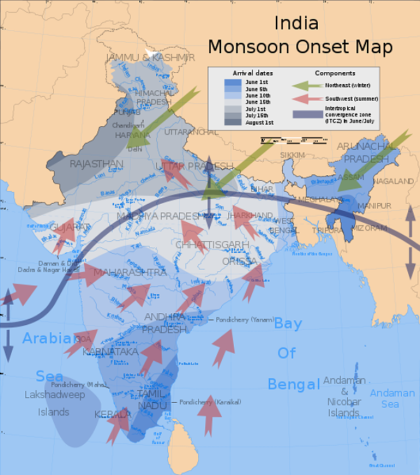
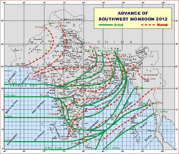
The monsoon route is currently being tracked in central India. It is slowly advancing towards the northern region while the subcontinent experiencing 39 degrees Celsius. Last year, pre-monsoons had already arrived in mid-June, and monsoon rains had arrived by the end of June.
India’s crucial monsoon rains should pick up in July after a slow start over vast swathes of the country, which has threatened crops from rice to sugar. India is the country of 1.2 billion people that is one of the world’s leading producers of rice, sugar, wheat and cotton. July and August are key months for planting and when India usually receives the maximum amount of rain. Monsoon rains typically sweep the subcontinent from June to September.

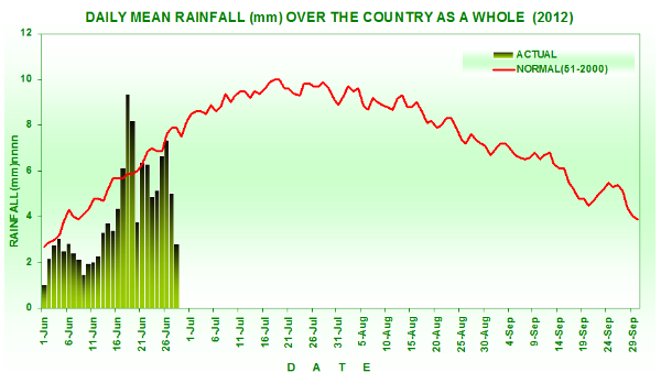
The rains have been abundant in India’s northeast where raging floods have forced hundreds of thousands of people to flee homes but weak in the vital northwestern grain bowl and oil seed-growing central regions. For the past week, monsoon rains were 18 % below average while for June as a whole they have been 23 % below average.
India’s 235 million farmers still rely on the erratic rains to soak around 60 % of the country’s farmland – despite calls for the government to improve irrigation and water-harvesting methods to ensure more stable crop output.
India this month said it would maintain its forecast for an average monsoon. But the meteorological department was spectacularly wrong in its forecast in 2009 when it predicted a normal monsoon and the country suffered its worst drought in 37 years. The drought sent food prices rocketing, causing huge hardship for the country’s hundreds of millions of poor.

CURRENT MONSOON CONDITIONS
Monsoon Watch
♦ The Northern Limit of Monsoon (NLM) continues to pass through Lat 21.0°N/ Long. 60.0° E, Lat 21.0°N/ Long. 65.0°E, Veraval, Navsari, Malegaon, Betul, Jabalpur, Sidhi, Varanasi, Gorakhpur and Lat 28.0°N/ Long. 83.0°E.
According to IMD, analysis of current meteorological conditions indicates increase in rainfall activity over east, central and also over northwest India due to development of seasonal eastwest trough with embedded upper air cyclonic circulation.

Heat wave to severe heat wave conditions are prevailing over some parts of Punjab, Haryana, Delhi,
Rajasthan, Uttar Pradesh and north Madhya Pradesh. The highest maximum temperature of 46.0°C has been
recorded at Churu( Rajasthan).
Major Feature of Weather Forecast up to 0830 hours IST of 04th July, 2012
♦ Rain/thundershowers would occur at many places over Maharashtra, Karnataka, Lakshadweep and Andaman & Nicobar Islands.
♦ Rain/thundershowers would occur at many places over Orissa, south Chhattisgarh and Andhra Pradesh.
♦ Rain/thundershowers would occur at a few places over Gujarat region, south Madhya Pradesh, West Bengal & Sikkim and northeastern states.
♦ Rain/thundershowers would occur at one or two places over Bihar, Jharkhand, north Chhattisgarh, north Madhya Pradesh and east Uttar Pradesh during next 48 hours and increase thereafter.
♦ Rain/thundershowers would occur at one or two places over rest parts of the country.
♦ Maximum temperature would fall by 24°C over Uttar Pradesh, east Rajasthan, east and central India during next 23 days.
Weather Warning
♦ Heavy rainfall would occur at one or two places over Konkan & Goa, Coastal Karnataka, Telangana, coastal Andhra Pradesh, south Chhattisgarh and Orissa during next 48 hours.
Weather Outlook for subsequent 4 days up to 0830 hours IST of 08th July, 2012
♦ Rain/thundershowers would occur at many places over west coast, east and adjoining central India and northeastern states.
♦ Increase in rainfall activity over northwest India.

Torrential monsoon rains triggered floods which swamped villages in eastern India and forced at least 1.3 million people to leave their homes for higher ground. The death toll from flood-related accidents in worst-hit Assam rose to 31 with five more deaths reported overnight from the northeastern state, regional Agriculture Minister Nilamoni Sen Deka told AFP.
21 of Assam’s 27 districts faced floods which began last weekend when annual monsoon rains lashed the tea and oil-rich state bordering Bangladesh. In the adjoining northeastern Indian states of Arunachal Pradesh and Manipur, pounding rains brought flash floods. There were no casualties reported from Arunachal Pradesh, which borders China, and Manipur which is adjacent to Myanmar.
Authorities were also keeping a close watch on swollen rivers in rain-lashed West Bengal state in eastern India. In neighbouring Bihar state, people fled their homes in two districts as the Kosi river threatened to overflow its banks, officials said.
The situation is very critical as floods have destroyed property and crops.
Sources: HindustanTimes, India Meteorological Department (MD)
Featured image: A sunset view from a beach in Tamil Nadu, India of monsoon clouds over the Bay of Bengal.

Commenting rules and guidelines
We value the thoughts and opinions of our readers and welcome healthy discussions on our website. In order to maintain a respectful and positive community, we ask that all commenters follow these rules:
We reserve the right to remove any comments that violate these rules. By commenting on our website, you agree to abide by these guidelines. Thank you for helping to create a positive and welcoming environment for all.