“Super Derecho” of June 29, 2012. – One of the most destructive complexes of thunderstorms in memory
On June 29, 2012, a windstorm started in northwestern Indiana, and traveled more than 1,000 kilometers (600 miles) eastward across the Midwest and mid-Atlantic, cutting power to millions and killing thirteen people. More than 500 damaging wind reports were received by NOAA’s Storm Prediction Center (SPC) as the derecho took roughly 12 hours to race from northern Indiana to the southern mid-Atlantic coast.
The fast-moving storm toppled trees, downed power lines and left more than a million residents without power in the District of Columbia alone. Power companies warned it could take several days to restore electricity completely in some areas as much of the United States sweltered in a record-breaking heat wave. About 2.2 million homes and businesses from Illinois to New Jersey were still without power Monday morning, with the biggest concentration of outages in the Washington area.

The storm was what meteorologists call a derecho. A derecho is defined as a widespread and long-lived wind storm that accompanies rapidly moving showers or thunderstorms. The most severe derechos are given the adjective “super.” Deriving its name from the Spanish term for “straight ahead,” derecho storms generally blow in one direction. They do not swirl like tornadoes, but they can cause tornado-style damage. The U.S. National Oceanic and Atmospheric Administration (NOAA) reported that the wind gusts in the June 29 derecho rivaled those of an EF-1 tornado. Winds gusted to 146,5 km/h (91 mph) at the Fort Wayne International Airport, Ind., Friday afternoon.
")
The June 29 derecho occurred along the boundary of two air masses. In the north, the air was stable and dry. In the south, the air was unstable and moist. And hot. The Capital Weather Gang reported that, before the derecho began, areas affected by the southern air mass were facing record-high temperatures – 43 degrees Celsius (109 degrees Fahrenheit) in Nashville, Tennessee, and Columbia, South Carolina; and 40 degrees Celsius(104 degrees ) in Washington, DC. This hot, humid air provided fuel for the windstorm, which pulled the air skyward, then returned it in violent downdrafts.


Derechos likely occur in other areas of the world where meteorological conditions are favorable for their development. However, only one such event has been formally documented in recent years. On July 10, 2002, a serial derecho occurred over eastern Germany and adjacent portions of neighboring European countries. In Berlin and surrounding areas, 8 people were killed and 39 were injured, mainly from falling trees. In Bangladesh and adjacent parts of India, a type of storm known as a “Nor’wester” occasionally occurs in the spring. From various descriptions and knowledge of the meteorological environments involved, it appears that some of these storms may be progressive derechos.
Derechos in the United States most commonly occur along two axes. One extends along the “Corn Belt” from the upper Mississippi Valley southeast into the Ohio Valley, and the other from the southern Plains northeast into the mid Mississippi Valley (figure below). During the cool season (September through April), derechos are relatively infrequent but are most likely to occur from east Texas into the southeastern states. Although derechos are extremely rare west of the Great Plains, isolated derechos have occurred over interior portions of the western United States, especially during spring and early summer.

Here is a list of selected of scientific papers about derechos and the convective systems responsible for their development. In addition to presenting analyses of some well-documented events, these papers describe what is known about the formation and mechanics of derecho-producing convective systems.
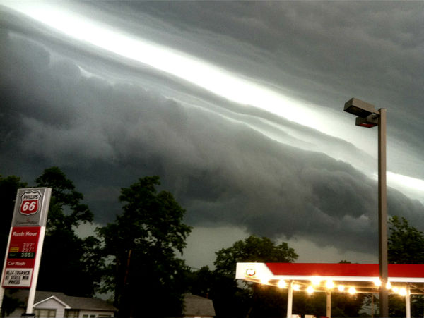
Featured image: Shelf cloud that preceded the derecho in LaPorte, IN (courtesy of Kevin Gould)
Sources: EarthObservatory, AccuWeather, US National Weather Service, Capital Weather Gang, US Storm Prediction Center
[…] « The Watchers – Earth Changes U.S. electrical grid system suffers ‘catastrophic damage’ from storms — Earth Changes — Sott.net » The Watchers – “Super Derecho” of June 29, 2012. – One of the most destructive complexes of thunderstorms in memory The Watchers – “Super Derecho” of June 29, 2012. – One of the most destructi…: […]
DUTCHSINSE forecast all of this. We are all victims of GEO-ENGINEERING and are destined to be exposed to the TESLA BASED experiments the good old USAF planned for us 25 years ago.
Wake up America…. or as Bill Hicks used to say…switch on AMERICAN GLADIATOR and BE HAPPY with your BUD and BIGMAC
If we Don’t Get those Jets out of the Jet Stream, their will be a lot more HELL!
80,000 TONS OF Co2 per Hour over the United States!
I Talked with EPA Wednesday and told them that the only way Congress will take any action if a Tornado would hit Washington or the Temperature would get up to 125 degrees, which I think it will in August! Well I was Part right! Can’t the MEDIA figure this out, what are they afraid off?
They are afraid when the people find out, that it is the Co2, in the Jet stream, and they will sue the Airline and Oil industry up and down for the damages. I am surprised it hasn’t happen yet. Their is only one earth, and when that is gone, everything, and anything is GONE!