Earthquake magnitude 5.7 in eastern Mediterranean Sea
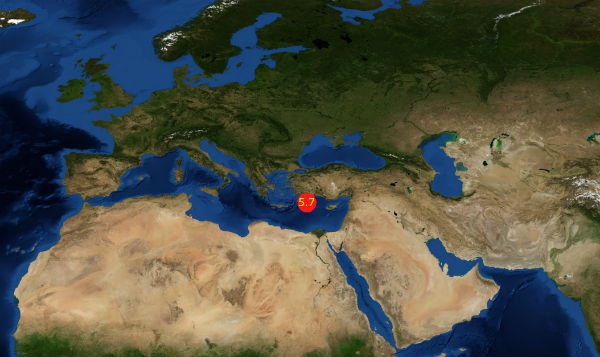
Strong earthquake measuring M5.7 according to EMSC was recorded on July 9, 2012 at 13:54 UTC in eastern Mediterranean Sea. Location of epicenter is 83 km (51 miles) SSW of Kalkan, Turkey and 111 km (68 miles) SE of Rodos, Greece. EMSC recorded depth of epicenter at 54 km.
However, local Turkish seismological centers like Kandili Observatory and Bogazici University reported magnitude 6.0 with depth of 51 km. USGS reported magnitude 5.6 at depth of 46.9 km.


The earthquake was felt in a wide area along the countries of the Eastern Mediterranean sea. The intermediate depth will make that this earthquake will be felt as a light shaking in countries like Greece, Turkey, Cyprus, Lebanon, Egypt and others in region.

The closest populated areas to the epicenter are Rhodos (Greece) and Kalkan (Turkey). A lot of tourists will have felt this earthquake. Tourists are in general “totally unprepared” towards earthquakes. Most of the tourists are behaving completely opposite than they should do because of a total lack of preparedness (tourist organizations are afraid to inform tourists about the earthquake dangers).

")
For now there are no reports of injuries or significant economic danger. And there is no danger of tsunami.
[…] Continue Reading… March 11, 2011 earthquake that hit Japan and generated massive tsunami, disturbed upper atmosphere in a way that was detectable by GPS receivers. Jet Propulsion Laboratory (JPL) at California Institute of Technology created excellent animation of event. Embedded video from NASA Jet Propulsion Laboratory California Institute of Technology Japan earthquake and tsunami disturbed upper atmosphere (animation) Posted on July 9, 2012 | 2 Comments March 11, 2011 earthquake that hit Japan and generated massive tsunami, disturbed upper atmosphere in a way that was detectable by GPS receivers. Jet Propulsion Laboratory (JPL) at California Institute of Technology created excellent animation of event. Embedded video from NASA Jet Propulsion Laboratory California Institute of Technology […]