Strong swarm of earthquakes continue on Kuril Islands
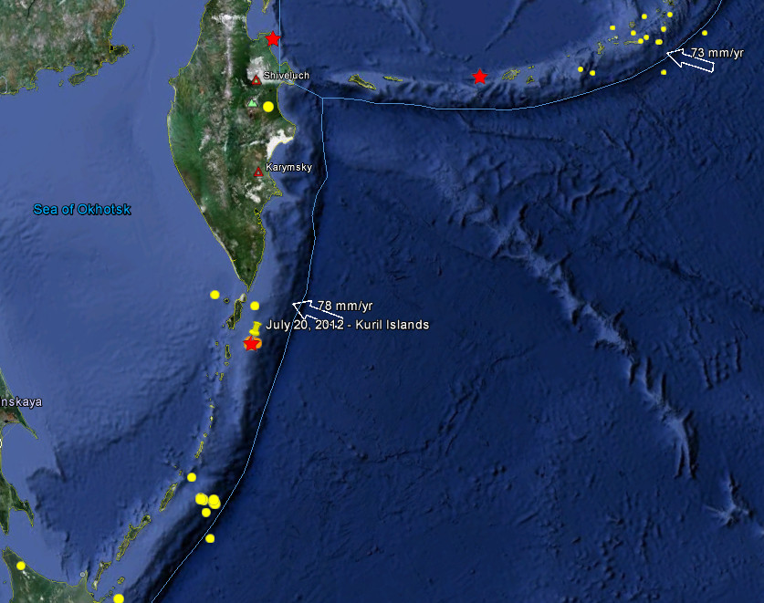
July 20th did not start so well for Kuril Islands. On July 15 we reported swarm of earthquakes on Kuril Island for seventh day in a row (link here), while it showed less activity for last couple of days today we had 5 strong ones again. The strongest one was reported at magnitude 6.3 on July 20, 2012 at 06:32 UTC. Recorded depth was 22.7 km (14.1 miles) by USGS. Epicenter location was 137 km (85 miles) S of Severo-Kuril’sk, Russia (49.418°N, 155.935°E). 20 minutes earlier, at 6:10 UTC we had magnitude 6.0 at depth of 22.7 km (14.1 miles).
The earthquakes moderate depth and the location of both epicenters, on the ocean, should have reduced the intensity making both of them “harmless”. A tsunami is not possible because the magnitudes are not big enough to create one.
These earthquakes have had a low humanitarian impact based on the magnitude and the affected population and their vulnerability. There are about 700 people within 100km radius.
2 hours later USGS downgraded the 6.3 to 5.8 and updated the depth to 22.4km. The data for the earthquake at 6:10 UTC was unchanged.
At the time of writing EMSC still reported a magnitude 6.3 at 6:32 UTC and 6.0 at 6:10 UTC. But the major difference was in depth. EMSC reported depth of 10km for both earthquakes! Some time later EMSC added another earthquake which was not reported by USGS – the magnitude was 4.8 and the time was at 6:27 UTC.
This is how the USGS data looked like at 8:06 UTC:
Update time = Fri Jul 20 8:06:06 UTC 2012
| MAG | UTC DATE-TIME y/m/d h:m:s |
LAT deg |
LON deg |
DEPTH km |
Region | |
|---|---|---|---|---|---|---|
| MAP | 6.3 | 2012/07/20 06:32:56 | 49.348 | 156.170 | 9.9 | KURIL ISLANDS |
| MAP | 6.0 | 2012/07/20 06:10:26 | 49.418 | 155.935 | 22.7 | KURIL ISLANDS |
| MAP | 5.3 | 2012/07/20 03:40:14 | 49.399 | 155.831 | 22.2 | KURIL ISLANDS |
| MAP | 5.0 | 2012/07/20 01:19:58 | 49.385 | 156.029 | 15.2 | KURIL ISLANDS |
…and how it looked like some 20 minutes later:
Update time = Fri Jul 20 8:34:32 UTC 2012
| MAG | UTC DATE-TIME y/m/d h:m:s |
LAT deg |
LON deg |
DEPTH km |
Region | |
|---|---|---|---|---|---|---|
| MAP | 5.8 | 2012/07/20 06:32:58 | 49.355 | 156.152 | 24.2 | KURIL ISLANDS |
| MAP | 6.0 | 2012/07/20 06:10:26 | 49.418 | 155.935 | 22.7 | KURIL ISLANDS |
| MAP | 5.3 | 2012/07/20 03:40:14 | 49.399 | 155.831 | 22.2 | KURIL ISLANDS |
| MAP | 5.0 | 2012/07/20 01:19:58 | 49.385 | 156.029 | 15.2 | KURIL ISLANDS |
EMSC – magnitude, depth and location map

Larger view of the area
Read our earlier report on earthquake swarm at Kuril Islands and possible connection to reports of imminent threat by Russian Academy of Science :
Commenting rules and guidelines
We value the thoughts and opinions of our readers and welcome healthy discussions on our website. In order to maintain a respectful and positive community, we ask that all commenters follow these rules:
We reserve the right to remove any comments that violate these rules. By commenting on our website, you agree to abide by these guidelines. Thank you for helping to create a positive and welcoming environment for all.