Unusual cloud pattern over Brisbane
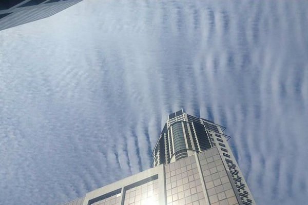
An unusual cloud pattern formed over Brisbane and southeast Queensland on August 9, 2012. According to Weatherzone meteorologist Josh Fisher, this pattern represents a signal that the weather is about to turn cold, a harbinger of cooler weather. It’s a high cloud forming ahead of a cold front that is crossing through New South Wales at the moment.
These clouds form in continuous strong winds blowing at the high altitudes. The turbulence from these strong winds creates the wave-like appearance. The clouds comprise tiny ice crystals and though it is not known how long they are going to stay around the temperature is expected to drop from a maximum of 26 degrees today to 18 degrees tomorrow.

Strange clouds over Brisbane gallery
There is some similarity with so-called “earthquake clouds”. A few scientists claim to have observed clouds associated with a seismic event, sometimes more than 50 days in advance of the earthquake. Some have even claimed to accurately predict earthquake occurrences by observing clouds. However, these claims have very little support in the scientific community.
Sources: BrisbaneTimes
HAARP can’t do that. It is normal, just like ripples in the sand or water. From ‘Topic Way’ – Two additional categories derived from the cumuliform group are stratocumuliform which are cumuliform with stratiform characteristics (rolled or rippled), and cumulonimbiform, towering cumuliform clouds often with complex structures that include cirriform tops and multiple accessory clouds. http://www.topicway.com/dictionary/List%20of%20cloud%20types
Do you remember the huge rain event on the Gold Coast in early October last year, the Tweed river flooded, International flights out of the Gold Coast were delayed one day, It poured & poured all day & night, That particular event confirmed for me the use of HAARP, two nights before I was up late & checked the BOM radar, there over the whole region from Kyogle to just south of Brisbane was a HUGE Doughnut shaped cloud pattern showing up like it was cut out with a cookie cutter, perfect round with the centre gone,I then noticed straight lines of energy or cloud (who knows) showing up radiating from near Pt Hedland, Esperance & just outside Hobart, it looked like the whole box & dice had been pulled out & was operating at the same time, two days later BAM !! huge event right on the bullseye, that for me was the final nail in the coffin , These Satanists have found a new toy to play with to help fill their coffers, a new cash cow,break things fix em again, beak things fix em again, meanwhile blame Man made global warming & fleece them for some more tax money at the same time to fix the problem you are covertly creating with your new Tesla toy ! , you don’t even need bombs now electricity is at below cost when you own the country & the sheep foot the bill ha ha, awesome system for some.
I took a picture of a similar cloud formation over our home in Northern Michigan on March 10, 2012. This cloud pattern extended from horizon to horizon and was particularly striking because of the deep blue sky peaking from between the lines of clouds: http://www.facebook.com/photo.php?fbid=411392962210593&set=a.101872383162654.4572.100000196783320&type=3&theater
I saw cloud formation similar to this two days ago here in Long Beach, Ca.
[…] [PHOTOS] Share this:ShareEmailFacebookStumbleUponLike this:LikeBe the first to like this. […]
Marc, I’ve been watching the radar since the middle of the Victorian drought (praying for rain:) and very much noticed the radar patterns during the drought breaking rains of early 2010. (A weather modification company Aquiess claimed to have made it rain on the Victorian bush fires.) All the while the Brisbane radar was displaying radial lines. They had stopped after about June 2010 but have restarted as of the last couple of months. The exact radar anomaly appeared in Melbourne before the super hail storm hit on March 6 as appeared in Perth a week later when they experienced the exact same hail. See http://colinandrews.net/BOM-MysterySolved.html for more info. I have many pictures of these types of clouds in Melbourne and usually find a radar anomaly has occurred in the previous 24 – 48 hours. Also visited NNSW last year and saw the radial skies as you described.
These clouds are becoming more frequent in the UK. Could it be due to star water?
These clouds were a regular feature in Singapore-a little dot city state, The chemtrails depending on formula do create these ribbed patterns. Got loads of such pictures in SG. Have done almost two year of research. All the antennas installed on tall buildings do heat up the ionosphere which starts 50km up. I cant verify that that HAARP have anything to with it directly but the idea behind it have been well accepted globally even towards making a mirror / anti-satellite mission. Just goo gle ear th and click street view and you locate cloud seeding in all major cities.
Globally, the nations want control. They wants to control their own backyard. They work like little gods telling *the sky*, “you rain when you are told and you dont when we the government tells you not to”.
Just a late thought to add to my comment above…
If anyone remembers the strange radar pasterns that were visible on the Bureau of Meteorology (BOM) Gov’t website about 3 years ago over Melbourne, Sydney and WA that were described at the time as being caused by HAARP – The pattern of the clouds over Brisbane also resembled these, very much so…
I live in Brissy Sth Side and watched these clouds for well over 3 hours. The pictures as shown here, while accurate do NOT give a very good visualization aspect of the whole sky appearance the justice it deserves.
I described it to my brother in Melbourne as resembling a GIANT COBWEB covering the whole sky… It was definitely radial in appearance with spoke like arms radiating from a central core of blue clear sky and the ribs or waves between the spokes were basically straight between the spokes… with the change in radial direction occurring where the ribs intersected the spokes (if that makes any sense)…
In simple terms imagine a cobweb with the center part missing and overlay it across the sky… that was the overall visualization effect.
At ground level there was little or no wind but these clouds raced across at a pretty fair rate but without change in their appearance… a bit like sliding a painted pane of glass across the sky…
It was quite stunning really. I certainly have never seen anything like that before.
HAARP?
This is what electromagnetic radiation in the atmosphere looks like, in other words weather modification. Check out the Brisbane radar.
BRING IT ON, NEED SOMETHING TO WAKE THE AUSTRALIAN SHEEP UP. GIVE THEM A LITTLE RUMBLE, I AM READY!
Its called HAARP.
Australia has these located in a lot of the defence bases around australia – wagga, canberra, brisbane, townsvill,e newcastle.
You will see beam like lines showing up on weather radar at http://www.bom.gov.au – these are used to steer weather cells around by heating and cooling parts of the atmosphere.
the ribbed cloud patterns show the haarp waves heating the clouds up and burning them off. If you could work out the distance between the ribs , you could work out the HAARP frequency being used.