Category 1 Hurricane Isaac lashing the Gulf Coast with thunderstorms, gusty winds and storm surge flooding
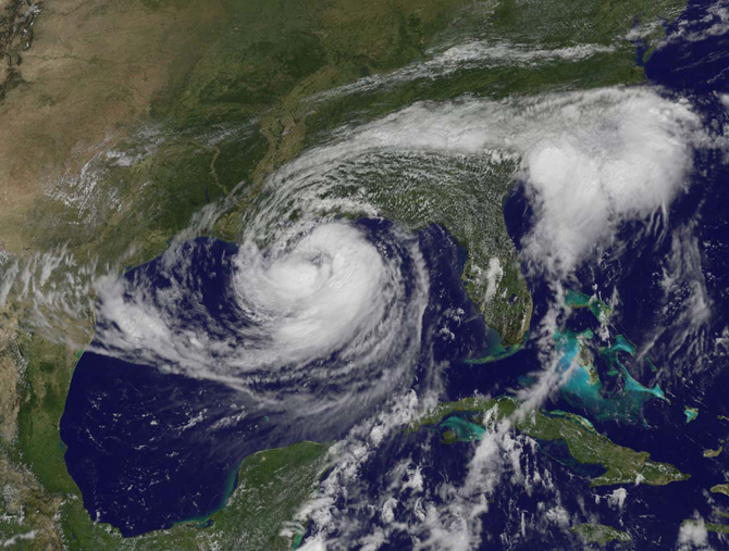
Residents along the northern Gulf coast are bracing for the arrival of Isaac, which was recently upgraded to a Category 1 hurricane. Center of Isaac nearing the coast of southeast Louisiana. Storm surge flooding already occurring along the coast of southeast Louisiana. Dangerous surf and rip current conditions will continue to affect the West Coast of Florida and portions of the northern Gulf Coast for the next day or so. The center of Hurricane Isaac should reach the coastline of southeastern Louisiana during the next few hours and continue moving farther inland over southeastern Louisiana. The five-day forecast suggested that the hurricane and its remnants would head straight up the Mississippi River basin and perhaps to the Ohio River.
Nearly 100,000 people left without power as Hurricane Isaac makes landfall, almost half in Orleans Parish.

Hurricane Isaac has officially made landfall in far southeastern Louisiana in Plaquemines Parish with maximum sustained winds of 80 mph at 6:45 p.m. CT Tuesday. He will move back out over West Bay before a second landfall between Grand Isle and Morgan City, Louisiana, tonight.
At 23:00 UTC the center of Hurricane Isaac was located by NOAA Doppler radars near latitude 28.9 north and longitude 89.2 west. Isaac is moving toward the northwest near 8 mph (13 km/h). A northwestward motion at a slightly slower speed is expected over the next day or two. Maximum sustained winds are near 80 mph (130 km/h) with higher gusts.
Hurricane-force winds extend outward up to 60 miles (95 km) mainly to the northeast and east of the center. Tropical-storm-force winds extend outward up to 185 miles (295 km). The minimum central pressure reported by reconnaissance aircraft was 970 mb…28.64 inches.

NHC forecasters expected Isaac to strengthen a bit before reaching shore, and warned of potential flooding from rainfall of 7 to 14 inches (18 to 36 centimeters), with localized precipitation up to 20 inches (50 centimeters). They also warned of a storm surge that could reach 6 to 12 feet (2 to 3.5 meters), depending on the timing of landfall and of local tides. Though just a category 1 storm, Isaac’s slow forward motion had the potential to pile up more water in the storm surge. Winds and storm surges are worst on the right/northeastern side of hurricanes.
As Isaac impacts the Gulf of Mexico, oil and gas companies have evacuated workers and shut down production.

Watches and warnings in effect
A Hurricane Warning is in effect for east of Morgan City Louisiana to the Mississippi-Alabama border, including metropolitan New Orleans, Lake Pontchartrain and Lake
Maurepas. A Hurricane Watch is in effect for Intracoastal City to Morgan City Louisiana.
A Tropical Storm Warning is in effect for the Mississippi-Alabama border to Destin Florida and Morgan City to Cameron Louisiana. A Tropical Storm Watch is in effect for east of High Island Texas to just west of Cameron Louisiana.

At 23:00 UTC the center of Hurricane Isaac was located by NOAA Doppler radars near latitude 28.9 north and longitude 89.2 west. Isaac is moving toward the northwest near 8 mph (13 km/h). A northwestward motion at a slightly slower speed is expected over the next day or two. Maximum sustained winds are near 80 mph (130 km/h) with higher gusts.
Hurricane-force winds extend outward up to 60 miles (95 km) mainly to the northeast and east of the center. Tropical-storm-force winds extend outward up to 185 miles (295 km). The minimum central pressure reported by reconnaissance aircraft was 970 mb…28.64 inches.
The combination of a storm surge and the tide will cause normally dry areas near the coast to be flooded by rising waters. The water could reach the following depths above ground if the peak surge occurs at the time of high tide:
* Mississippi and southeastern Louisiana…6 to 12 ft
* Alabama…4 to 8 ft
* south-central Louisiana…3 to 6 ft
* Florida Panhandle…3 to 6 ft
* Apalachee Bay…2 to 4 ft
* remainder of Florida West Coast…1 to 3 ft
The deepest water will occur along the immediate coast in areas of onshore winds. Surge-related flooding depends on the relative timing of the surge and the tidal cycle and can vary greatly over short distances. The surge will be accompanied by large and dangerous waves.
A storm surge of 8.0 feet was recently reported at a National ocean service tide gauge at Shell Beach Louisiana. A storm surge of 5.3 feet was observed at a National ocean service tide gauge in Waveland Mississippi. A storm surge of 3.1 feet was also reported in Pensacola Florida.
Heavy rains could cause severe flooding, as the parched ground and dried up crops will not necessarily absorb that much water.
State of Louisiana preparedness plan
Animated hurricane evacuation routes and contraflow map

Summary
After crossing the southwestern tip of Haiti during the early morning hours of the 25th of August, Isaac paralleled the northern coast of Cuba the following day and moved through the Florida Straits with the center passing about 40 miles (~65 km) south of Key West, Florida on the afternoon of the 26th. As it entered the southeastern Gulf of Mexico on the afternoon of August 26th, Isaac’s wind field was spread over a large area, making it less responsive to changes in central pressure. Dry air intrusions hindered the development of an inner core. On August 28, 2012, tropical storm Isaac achieved hurricane force and was predicted to make landfall on the Gulf Coast of the United States sometime overnight.
Katrina moved up from the south over the Mississippi Delta on a curved path. Isaac is likely to be rolling in straight from the southeast, so the counterclockwise flow around the storm will drive a significant surge toward Chanderleur Sound, Lake Borgne and Lake Pontchartrain early on and for a number of hours. A storm surge of 3 to 6 feet is forecast for Lake Pontchartrain with the highest levels on the western end of the lake as the storm approaches.

NASA is just days from launching an intensive multi-year study of hurricane formation and evolution in the Atlantic Ocean. Known as the Hurricane and Severe Storm Sentinel (HS3) mission, the project will use robotic Global Hawk airplanes to fly over and through storm systems. A principal goal is to learn more about what makes tropical storms intensify into hurricanes.

Radar
- New Orleans – Long Range (NOAA)
- Mobile – Long Range (NOAA)
Satellite Animations
- Storm-Centered Infrared (GOES 13; NOAA/SSD)
- Storm-Centered Infrared (Aviation Color Enhancement) (GOES 13; NOAA/SSD)
- Storm-Centered Water Vapor (GOES 13; NOAA/SSD)
- Storm-Centered Visible (GOES 13; NOAA/SSD)
- Storm-Centered Visible (Colorized) (GOES 13; NOAA/SSD)
- Gulf of Mexico Infrared (GOES 13; NOAA/SSD)
- Gulf of Mexico Infrared (Aviation Color Enhancement) (GOES 13; NOAA/SSD)
- Gulf of Mexico Water Vapor (GOES 13; NOAA/SSD)
- Gulf of Mexico Visible (GOES 13; NOAA/SSD)
- Gulf of Mexico Visible (Colorized) (GOES 13; NOAA/SSD)
NHC Atlantic Wallet 4 – Hurricane ISAAC
Latest advisories and graphics for Hurricane ISAAC (AT09)
- Hurricane ISAAC Public Advisory Number 31A
- Hurricane ISAAC Aviso Publico Number 31A
- Hurricane ISAAC Forecast Advisory Number 31
- Hurricane ISAAC Forecast Discussion Number 31
- Hurricane ISAAC Wind Speed Probabilities Number 31
- Hurricane ISAAC Position Estimate
- Hurricane ISAAC Graphics
- Hurricane ISAAC Probabilistic Storm Surge Graphics
- Hurricane Local Statement for New Orleans / Baton Rouge, LA
- Hurricane Local Statement for Lake Charles, LA
- Hurricane Local Statement for Jackson, MS
- Hurricane Local Statement for Mobile, AL / Pensacola, FL
- Hurricane Local Statement for Tallahassee, FL
- Hurricane Local Statement for Shreveport, LA
- Hurricane Local Statement for San Angelo, TX
- Hurricane ISAAC 5-Day Track, Uncertainty Cone, Warnings (.shp)
- Hurricane ISAAC Best Track Information (.shp)
- Hurricane ISAAC Best Track Information (.kmz)
- Hurricane ISAAC Forecast Information (.shp)
- Hurricane ISAAC Wind Speed Probabilities – 0.5 Degree Multiple Basins (.shp)
- Hurricane ISAAC Wind Speed Probabilities – 0.1 Degree Multiple Basins (.shp)
- Hurricane ISAAC Probabilistic Storm Surge Graphics (.shp)
- Hurricane ISAAC Probabilistic Storm Surge Graphics (.kmz)
- Hurricane ISAAC Exceedance Storm Surge Graphics (.shp)
- Hurricane ISAAC Exceedance Storm Surge Graphics (.kmz)
- Cyclone Information by XML (protoype)
Commenting rules and guidelines
We value the thoughts and opinions of our readers and welcome healthy discussions on our website. In order to maintain a respectful and positive community, we ask that all commenters follow these rules.