Earthquake M 6.2 struck Gulf of California
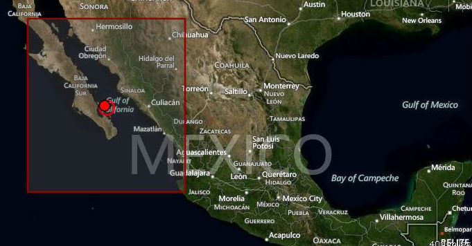
Strong M6.2 earthquake struck in Gulf of California on September 25, 2012 at 23:45:26 UTC. The epicenter was located 75 km (47 miles) N (11°) from La Paz, Baja California Sur and 154 km (96 miles) E (98°) from Constitución, Baja California Sur, Mexico (24.835°N, 110.152°W) at depth of 10.1 km (6.3 miles) according to USGS. EMSC recorded magnitude 5.9 at depth of 33 km.
It was followed by few aftershocks at the same depth, the strongest measuring M4.8.


Areas off Mexico’s coastline on the Gulf of California, including the Baja California Peninsula, are riding northwestward on the Pacific plate. Rather than one plate subducting, the Pacific and North American plates grind past each other, creating a slip fault that is the southern extension of the San Andreas fault in California. Motion along this fault in the past pulled Baja California away from the coast, creating the Gulf of California. Continued motion along this fault is the source of earthquakes in western Mexico.


Commenting rules and guidelines
We value the thoughts and opinions of our readers and welcome healthy discussions on our website. In order to maintain a respectful and positive community, we ask that all commenters follow these rules:
We reserve the right to remove any comments that violate these rules. By commenting on our website, you agree to abide by these guidelines. Thank you for helping to create a positive and welcoming environment for all.