Active volcanoes in the world: October 3 – October 09, 2012
New unrest has been noticed around 5 volcanoes, ongoing activity was reported for 8 volcanoes. This report covers active volcanoes in the world recorded from October 3 – October 9, 2012 based on Smithsonian/USGS criteria.
The Weekly Volcanic Activity Report is a cooperative project between the Smithsonian’s Global Volcanism Program and the US Geological Survey’s Volcano Hazards Program. Updated by 23:00 UTC every Wednesday, notices of volcanic activity posted on these pages are preliminary and subject to change as events are studied in more detail. This is not a comprehensive list of all of Earth’s volcanoes erupting during the week, but rather a summary of activity at volcanoes that meet criteria discussed in detail in the “Criteria and Disclaimers” section. Carefully reviewed, detailed reports on various volcanoes are published monthly in the Bulletin of the Global Volcanism Network.
New activity/unrest: | Fuego, Guatemala | Lokon-Empung, Sulawesi | Paluweh, Lesser Sunda Islands (Indonesia) | Suwanose-jima, Ryukyu Islands (Japan) | Tengger Caldera, Eastern Java (Indonesia)
Ongoing activity: | Bagana, Bougainville | Batu Tara, Komba Island (Indonesia) | Galeras, Colombia |Karymsky, Eastern Kamchatka (Russia) | Kilauea, Hawaii (USA) | Manam, Northeast of New Guinea (SW Pacific) | Sakura-jima, Kyushu | Shiveluch, Central Kamchatka (Russia)
New activity/unrest
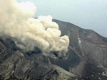
FUEGO, Guatemala
14.473°N, 90.880°W; summit elev. 3763 m
INSIVUMEH reported that on 3 October a hot lahar descended Fuego’s Ceniza drainage (SSW), carrying logs, branches, and blocks. During 4-5 October explosions ejected incandescent tephra 75-150 m above the crater, producing ash plumes that rose 600-900 m and drifted 10 km N and NW. Explosions generated shock waves and vibrated houses in local communities. Avalanches descended the Ceniza and Taniluyá drainages (SSW).
On 7 October the seismic network detected increased activity characterized by tremor, low-frequency earthquakes, and a period of constant explosions. Rumbling was heard and shock waves were detected. Ashfall was reported in Panimache I and II (8 KM SW), Morelia (9 km SW), and Santa Sofia (12 km SW). Incandescent block avalanches originating from the crater descended the flanks. During 7-8 October explosions ejected incandescent tephra 75-150 m above the crater, and generated ash plumes that drifted 10 km S and SW. On 8 October a lava flow traveled 100 m down the Ceniza drainage, producing incandescent block avalanches from the flow front. Avalanches descended the Taniluyá drainage. Ashfall was reported in Panimache I and II, Morelia, and Asunción.
Geologic summary: Volcán Fuego, one of Central America’s most active volcanoes, is one of three large stratovolcanoes overlooking Guatemala’s former capital, Antigua. The scarp of an older edifice, Meseta, lies between 3,763-m-high Fuego and its twin volcano to the N, Acatenango. Construction of Meseta volcano continued until the late Pleistocene or early Holocene, after which growth of the modern Fuego volcano continued the southward migration of volcanism that began at Acatenango. Frequent vigorous historical eruptions have been recorded at Fuego since the onset of the Spanish era in 1524, and have produced major ashfalls, along with occasional pyroclastic flows and lava flows. The last major explosive eruption from Fuego took place in 1974, producing spectacular pyroclastic flows visible from Antigua.
LOKON-EMPUNG, Sulawesi
1.358°N, 124.792°E; summit elev. 1580 m
According to the Darwin VAAC, CVGHM reported that on 6 October an ash plume from Lokon-Empung rose to an altitude of 3.7 km (12,000 ft) a.s.l.; the plume altitude was determined by wind data. A thermal anomaly was detected in satellite imagery. According to a news article, an eruption at 1405 on 7 October ejected incandescent tephra as high as 350 m above the crater and generated an ash plume that rose 1.5 km. The article also noted that Lokon-Empung had erupted 41 times in September and three times on 5 October.
Geologic summary: The twin volcanoes Lokon and Empung, rising about 800 m above the plain of Tondano, are among the most active volcanoes of Sulawesi. Lokon, the higher of the two peaks (whose summits are only 2.2 km apart) has a flat, craterless top. The morphologically younger Empung volcano has a 400-m-wide, 150-m-deep crater that erupted last in the 18th century, but all subsequent eruptions have originated from Tompaluan, a 150 x 250 m wide double crater situated in the saddle between the two peaks. Historical eruptions have primarily produced small-to-moderate ash plumes that have occasionally damaged croplands and houses, but lava-dome growth and pyroclastic flows have also occurred.
PALUWEH, Lesser Sunda Islands (Indonesia)
8.32°S, 121.708°E; summit elev. 875 m
Based on seismic data and visual observations, CVGHM raised the Alert Level for Paluweh (also known as Rokatenda) from 1 to 2 (on a scale of 1-4) on 8 October.
Geologic summary: Paluweh volcano, also known as Rokatenda, forms the 8-km-wide island of Paluweh N of the volcanic arc that cuts across Flores Island. Although the volcano rises about 3,000 m above the sea floor, its summit reaches only 875 m above sea level. The broad irregular summit region contains overlapping craters up to 900 m wide and several lava domes. Several flank vents occur along a NW-trending fissure. The largest historical eruption of Paluweh occurred in 1928, when a strong explosive eruption was accompanied by landslide-induced tsunamis and lava-dome emplacement.
SUWANOSE-JIMA, Ryukyu Islands (Japan)
29.635°N, 129.716°E; summit elev. 799 m
Based on a pilot observation, the Tokyo VAAC reported that on 3 October an ash plume from Suwanose-jima drifted SW at altitude of 3 km (10,000 ft) a.s.l.
Geologic summary: The 8-km-long, spindle-shaped island of Suwanose-jima in the northern Ryukyu Islands consists of an andesitic stratovolcano with two historically active summit craters. Only about 50 persons live on the sparsely populated island. The summit of the volcano is truncated by a large breached crater extending to the sea on the east flank that was formed by edifice collapse. Suwanose-jima, one of Japan’s most frequently active volcanoes, was in a state of intermittent Strombolian activity from On-take, the NE summit crater, that began in 1949 and lasted nearly a half century. The largest historical eruption took place in 1813-14, when thick scoria deposits blanketed residential areas, after which the island was uninhabited for about 70 years. The SW crater produced lava flows that reached the western coast in 1813, and lava flows reached the eastern coast of the island in 1884.
TENGGER CALDERA, Eastern Java (Indonesia)
7.942°S, 112.95°E; summit elev. 2329 m
CVGHM reported that during 1 September-3 October diffuse white plumes from Tengger Caldera’s Bromo cone rose 50 m above the crater. Seismicity increased on 1 October, and during 1-3 October a sulfur odor was occasionally noted at the Bromo Observation Post. On 3 October the Alert Level was raised to 2 (on a scale of 1-4).
Geologic summary:. The 16-km-wide Tengger caldera in eastern Java is located at the northern end of a volcanic massif extending from Semeru volcano. The massive Tengger volcanic complex consists of five overlapping stratovolcanoes, each truncated by a caldera. The most recent is the 9 x 10 km wide Sandsea caldera, which formed incrementally during the late Pleistocene and early Holocene. An overlapping cluster of post-caldera cones was constructed on the floor of the Sandsea caldera within the past several thousand years. The youngest of these is Bromo, one of Java’s most frequently visited and most active volcanoes. More than 50 mild-to-moderate explosive eruptions have occurred since 1804.
Ongoing activity
BAGANA, Bougainville
6.140°S, 155.195°E; summit elev. 1750 m
Based on analyses of satellite imagery, the Darwin VAAC reported that on 3 October an ash plume from Bagana rose to an altitude of 4.3 km (14,000 ft) a.s.l. and drifted 65 km NW.
Geologic summary: Bagana volcano, occupying a remote portion of central Bougainville Island, is one of Melanesia’s youngest and most active volcanoes. Bagana is a massive symmetrical lava cone largely constructed by an accumulation of viscous andesitic lava flows. The entire lava cone could have been constructed in about 300 years at its present rate of lava production. Eruptive activity at Bagana is characterized by non-explosive effusion of viscous lava that maintains a small lava dome in the summit crater, although explosive activity occasionally producing pyroclastic flows also occurs. Lava flows form dramatic, freshly preserved tongue-shaped lobes up to 50-m-thick with prominent levees that descend the volcano’s flanks on all sides.
BATU TARA, Komba Island (Indonesia)
7.792°S, 123.579°E; summit elev. 748 m
Based on analyses of satellite imagery, the Darwin Volcanic Ash Advisory Centre (VAAC) reported that during 6-7 October ash plumes from Batu Tara rose to an altitude of 2.4 km (8,000 ft) a.s.l. and drifted 45 km W.
Geologic summary: The small isolated island of Batu Tara in the Flores Sea about 50 km north of Lembata (formerly Lomblen) Island contains a scarp on the eastern side similar to the Sciara del Fuoco of Italy’s Stromboli volcano. Vegetation covers the flanks of Batu Tara to within 50 m of the 748-m-high summit. Batu Tara lies north of the main volcanic arc and is noted for its potassic leucite-bearing basanitic and tephritic rocks. The first historical eruption from Batu Tara, during 1847-52, produced explosions and a lava flow.
GALERAS, Colombia
1.22°N, 77.37°W; summit elev. 4276 m
INGEOMINAS reported that during 2-9 October cameras around Galeras recorded daily emissions that drifted NW and often contained ash. Earthquakes were at most M 2.2 and occurred within 15 km of the crater at depths of less than 10 km. An M 2.2 earthquake on 8 October was located at a depth of 8 km, 7 km NE of the crater. The Alert Level remained at III (Yellow; “changes in the behavior of volcanic activity”).
Geologic summary: Galeras, a stratovolcano with a large breached caldera located immediately W of the city of Pasto, is one of Colombia’s most frequently active volcanoes. The dominantly andesitic Galeras volcanic complex has been active for more than 1 million years, and two major caldera collapse eruptions took place during the late Pleistocene. Longterm extensive hydrothermal alteration has affected the volcano. This has contributed to large-scale edifice collapse that has occurred on at least three occasions, producing debris avalanches that swept to the W and left a large horseshoe-shaped caldera inside which the modern cone has been constructed. Major explosive eruptions since the mid Holocene have produced widespread tephra deposits and pyroclastic flows that swept all but the southern flanks. A central cone slightly lower than the caldera rim has been the site of numerous small-to-moderate historical eruptions since the time of the Spanish conquistadors.
KARYMSKY, Eastern Kamchatka (Russia)
54.05°N, 159.45°E; summit elev. 1536 m
KVERT reported moderate seismic activity from Karymsky during 28 September-5 October. Seismic data indicated that possible ash plumes rose to an altitude of 4 km (13,100 ft) a.s.l. Satellite imagery showed a thermal anomaly on the volcano on 28 September and 2 October. The Aviation Color Code remained at Orange.
Based on and information from the Kamchatka Branch of the Geophysical Service (KGBS), the Tokyo VAAC reported that on 6 October ash plumes rose to altitudes of 6.1-6.7 km (20,000-22,000 ft) a.s.l. and drifted SE. The plume altitudes were based on seismic data analyses.
Geologic summary: Karymsky, the most active volcano of Kamchatka’s eastern volcanic zone, is a symmetrica lstratovolcano constructed within a 5-km-wide caldera that formed about 7,600-7,700 radiocarbon years ago. Construction of the Karymsky stratovolcano began about 2,000 years later. The latest eruptive period began about 500 years ago, following a 2,300-year quiescence. Much of the cone is mantled by lava flows less than 200 years old. Historical eruptions have been Vulcanian or Vulcanian-Strombolian with moderate explosive activity and occasional lava flows from the summit crater. Most seismicity preceding Karymsky eruptions has originated beneath Akademia Nauk caldera, which is located immediately S of Karymsky volcano and erupted simultaneously with Karymsky in 1996.
KILAUEA, Hawaii (USA)
19.421°N, 155.287°W; summit elev. 1222 m
During 3-9 October HVO reported that the circulating lava lake periodically rose and fell in the deep pit within Kilauea’s Halema’uma’u Crater. Periodic measurements indicated that the gas plume from the vent continued to deposit variable amounts of spatter and Pele’s hair onto nearby areas. On 5 October geologists using a laser range-finder measured the high lava level at 52 m below the floor of Halema’uma’u Crater, which was a new maximum level.
Lava flows reached the base of the pali in the Royal Gardens subdivision and flowed across the coastal plain, but were 1.6 km from the coast. At Pu’u ‘O’o Crater, incandescence was visible from lava flows in the S pit, lava circulating in the E pit, and from the W edge of the crusted N pit. An opening in the roof of the lava tube at the base of the SE flank of Pu’u ‘O’o also continued to glow until nearly the end of the reporting period.
Geologic summary: Kilauea, one of five coalescing volcanoes that comprise the island of Hawaii, is one of the world’s most active volcanoes. Eruptions at Kilauea originate primarily from the summit caldera or along one of the lengthy E and SW rift zones that extend from the caldera to the sea. About 90% of the surface of Kilauea is formed of lava flows less than about 1,100 years old; 70% of the volcano’s surface is younger than 600 years. A long-term eruption from the East rift zone that began in 1983 has produced lava flows covering more than 100 sq km, destroying nearly 200 houses and adding new coastline to the island.
MANAM, Northeast of New Guinea (SW Pacific)
4.080°S, 145.037°E; summit elev. 1807 m
RVO reported that variable low-level activity continued to be detected at Manam’s Southern Crater during 16-30 September. White and occasionally gray ash plumes rose from the crater during 16-24 September, and gray ash clouds were observed during 25-29 September. Only white plumes rose from the crater on 30 September. Ash clouds drifted NW, producing ashfall in the NW part of the island. Two vents in the SE valley, just below the summit crater, produced small-volume lava flows, channeled into the deep ravines on the upper slopes of the SE valley. Glow from the crater was visible on most nights. Incandescent lava fragments were ejected from the crater during 16-17, 19-20, and 24-28 September. The ejections were occasionally sub-continuous to fountaining. Roaring and rumbling noises were sometimes heard at the Bogia station on the mainland on 16, 21, and 26 September. White vapor plumes rose from Main Crater during the reporting period.
According to the Darwin VAAC a pilot reported an intermittent eruption with a diffuse ash plume on 8 October. During 8-9 October satellite imagery showed a thermal anomaly, and an ash plume that rose to an altitude of 3.4 km (11,000 ft) a.s.l. and drifted about 45 km ENE.
Geologic summary: The 10-km-wide island of Manam, lying 13 km off the northern coast of mainland Papua New Guinea, is one of the country’s most active volcanoes. Four large radial valleys extend from the unvegetated summit of the conical 1807-m-high basaltic-andesitic stratovolcano to its lower flanks. These “avalanche valleys,” regularly spaced 90 degrees apart, channel lava flows and pyroclastic avalanches that have sometimes reached the coast. Two summit craters are present; both are active, although most historical eruptions have originated from the southern crater, concentrating eruptive products during much of the past century into the SE avalanche valley. Frequent historical eruptions, typically of mild-to-moderate scale, have been recorded at Manam since 1616. Occasional larger eruptions have produced pyroclastic flows and lava flows that reached flat-lying coastal areas and entered the sea, sometimes impacting populated areas.
SAKURA-JIMA, Kyushu
31.585°N, 130.657°E; summit elev. 1117 m
Based on information from JMA, the Tokyo VAAC reported that explosions from Sakura-jima’s Showa Crater during 3-9 October produced plumes that rose to altitudes of 1.8-3 km (6,000-10,000 ft) a.s.l. and drifted W, SW, S, SE, and E. JMA reported that during 5-9 October explosions ejected tephra as far as 1.3 km from the crater. An explosion produced a small pyroclastic flow that traveled 300 m down the E side of Showa Crater.
Geologic summary: Sakura-jima, one of Japan’s most active volcanoes, is a post-caldera cone of the Aira caldera at the northern half of Kagoshima Bay. Eruption of the voluminous Ito pyroclastic flow was associated with the formation of the 17 x 23-km-wide Aira caldera about 22,000 years ago. The construction of Sakura-jima began about 13,000 years ago and built an island that was finally joined to the Osumi Peninsula during the major explosive and effusive eruption of 1914. Activity at the Kita-dake summit cone ended about 4,850 years ago, after which eruptions took place at Minami-dake. Frequent historical eruptions, recorded since the 8th century, have deposited ash on Kagoshima, one of Kyushu’s largest cities, located across Kagoshima Bay only 8 km from the summit. The largest historical eruption took place during 1471-76.
SHIVELUCH, Central Kamchatka (Russia)
56.653°N, 161.360°E; summit elev. 3283 m
Based on visual observations and analyses of satellite data, KVERT reported that during 28 September-5 October a viscous lava flow continued to effuse on the NW flank of Shiveluch’s lava dome, accompanied by hot avalanches and fumarolic activity. Satellite imagery showed a thermal anomaly on the lava dome on 28 September and during 1-3 October. Based on analyses of satellite imagery, notices from Yelizovo Airport (UHPP), and information from KVERT, the Tokyo VAAC reported that on 5 October ash plumes rose to an altitude of 2.1 km (7,000 ft) a.s.l. and drifted SE. The next day ash plumes rose to an altitude of 7 km (23,000 ft) a.s.l and again drifted SE. The Aviation Color Code remained at Orange.
Geologic summary: The high, isolated massif of Shiveluch volcano (also spelled Sheveluch) rises above the lowlands NNE of the Kliuchevskaya volcano group and forms one of Kamchatka’s largest and most active volcanoes. The currently active Molodoy Shiveluch lava-dome complex was constructed during the Holocene within a large breached caldera formed by collapse of the massive late-Pleistocene Strary Shiveluch volcano. At least 60 large eruptions of Shiveluch have occurred during the Holocene, making it the most vigorous andesitic volcano of the Kuril-Kamchatka arc. Frequent collapses of lava-dome complexes, most recently in 1964, have produced large debris avalanches whose deposits cover much of the floor of the breached caldera. Intermittent explosive eruptions began in the 1990s from a new lava dome that began growing in 1980. The largest historical eruptions from Shiveluch occurred in 1854 and 1964.
Source: Global Volcanism Program
Commenting rules and guidelines
We value the thoughts and opinions of our readers and welcome healthy discussions on our website. In order to maintain a respectful and positive community, we ask that all commenters follow these rules:
We reserve the right to remove any comments that violate these rules. By commenting on our website, you agree to abide by these guidelines. Thank you for helping to create a positive and welcoming environment for all.