Active volcanoes in the world: October 31 – November 6, 2012
New unrest has been noticed around 1 volcano, ongoing activity was reported for 9 volcanoes. This report covers active volcanoes in the world recorded from October 31 – November 6, 2012 based on Smithsonian/USGS criteria.
New activity/unrest: | Kizimen, Eastern Kamchatka (Russia)
Ongoing activity: | Fuego, Guatemala | Galeras, Colombia | Karymsky, Eastern Kamchatka (Russia) |Kilauea, Hawaii (USA) | Manam, Northeast of New Guinea (SW Pacific) | Nyiragongo, Democratic Republic of Congo | Popocatépetl, México | Reventador, Ecuador | Sakura-jima, Kyushu | Shiveluch, Central Kamchatka (Russia)
The Weekly Volcanic Activity Report is a cooperative project between the Smithsonian’s Global Volcanism Program and the US Geological Survey’s Volcano Hazards Program. Updated by 23:00 UTC every Wednesday, notices of volcanic activity posted on these pages are preliminary and subject to change as events are studied in more detail. This is not a comprehensive list of all of Earth’s volcanoes erupting during the week, but rather a summary of activity at volcanoes that meet criteria discussed in detail in the “Criteria and Disclaimers” section. Carefully reviewed, detailed reports on various volcanoes are published monthly in the Bulletin of the Global Volcanism Network.
New activity/unrest
KIZIMEN, Eastern Kamchatka (Russia)
55.130°N, 160.32°E; summit elev. 2376 m
KVERT reported that during 26 October-2 November moderate seismic activity at Kizimen was detected along with a thermal anomaly in satellite imagery. Video and satellite images showed lava flows effusing from the summit and the E flank, summit incandescence, strong gas-and-steam activity, and hot avalanches on the S flank. The Aviation Color Code was raised to Orange on 1 November. Based on information from the Kamchatka Branch of Geophysical Services (KGBS), the Tokyo VAAC reported that an ash plume drifted NE at an altitude of 5.2 km (17,000 ft) a.s.l. on 2 November. KVERT reported that during 2-3 November moderate seismicity indicated that possible ash plumes rose to altitudes of 4.5-4.8 km (14,800-15,800 ft) a.s.l. Video images showed gas-and-steam activity during 2-5 November. Incandescence above the crater and lava flow were observed on 5 November.
Geologic summary. Kizimen is an isolated, conical stratovolcano that is morphologically similar to Mount St. Helens prior to its 1980 eruption. The summit of Kizimen consists of overlapping lava domes, and blocky lava flows descend the flanks of the volcano, which is the westernmost of a volcanic chain north of Kronotsky volcano. The 2,376-m-high Kizimen was formed during four eruptive cycles beginning about 12,000 years ago and lasting 2,000-3,500 years. The largest eruptions took place about 10,000 and 8300-8400 years ago, and three periods of longterm lava-dome growth have occurred. The latest eruptive cycle began about 3,000 years ago with a large explosion and was followed by lava-dome growth lasting intermittently about 1,000 years. An explosive eruption about 1,100 years ago produced a lateral blast and created a 1.0 x 0.7 km wide crater breached to the NE, inside which a small lava dome (the fourth at Kizimen) has grown. A single explosive eruption, during 1927-28, has been recorded in historical time.
Ongoing activity
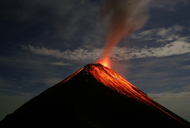
FUEGO, Guatemala
14.473°N, 90.880°W; summit elev. 3763 m
INSIVUMEH reported that during 1-2 November white fumarolic plumes from Fuego rose 100 m and drifted SW. Explosions ejected incandescent material 100 m above the lava dome, and produced ash plumes that rose almost 500 m and drifted 10 km SW. A lava flow traveled 350 m SSW down the Ceniza drainage. On 3 November heavy rain caused lahars that traveled down the Ceniza drainage, carrying tree branches and 2-m-wide blocks. During 3-6 November explosions generate ash plumes that rose 150-450 m and drifted W and NW. Incandescent material was ejected 100 m above the crater and generated avalanches near the crater. A lava flow traveled 600-800 m down the Ceniza drainage, producing incandescent block avalanches that reached vegetated areas.
Geologic summary: Volcán Fuego, one of Central America’s most active volcanoes, is one of three large stratovolcanoes overlooking Guatemala’s former capital, Antigua. The scarp of an older edifice, Meseta, lies between 3,763-m-high Fuego and its twin volcano to the N, Acatenango. Construction of Meseta volcano continued until the late Pleistocene or early Holocene, after which growth of the modern Fuego volcano continued the southward migration of volcanism that began at Acatenango. Frequent vigorous historical eruptions have been recorded at Fuego since the onset of the Spanish era in 1524, and have produced major ashfalls, along with occasional pyroclastic flows and lava flows. The last major explosive eruption from Fuego took place in 1974, producing spectacular pyroclastic flows visible from Antigua.
GALERAS, Colombia
1.22°N, 77.37°W; summit elev. 4276 m
INGEOMINAS reported that during 30 October-6 November seismicity at Galeras fluctuated but was slightly lower compared to the previous week. Sulfur dioxide gas emissions were low. Cameras around Galeras recorded gas-and-ash plumes rising from the crater on 30 October and 1 November. The Alert Level remained at III (Yellow; “changes in the behavior of volcanic activity”).
Geologic summary: Galeras, a stratovolcano with a large breached caldera located immediately W of the city of Pasto, is one of Colombia’s most frequently active volcanoes. The dominantly andesitic Galeras volcanic complex has been active for more than 1 million years, and two major caldera collapse eruptions took place during the late Pleistocene. Longterm extensive hydrothermal alteration has affected the volcano. This has contributed to large-scale edifice collapse that has occurred on at least three occasions, producing debris avalanches that swept to the W and left a large horseshoe-shaped caldera inside which the modern cone has been constructed. Major explosive eruptions since the mid Holocene have produced widespread tephra deposits and pyroclastic flows that swept all but the southern flanks. A central cone slightly lower than the caldera rim has been the site of numerous small-to-moderate historical eruptions since the time of the Spanish conquistadors.
KARYMSKY, Eastern Kamchatka (Russia)
54.05°N, 159.45°E; summit elev. 1536 m
KVERT reported moderate seismic activity from Karymsky during 26 October-2 November; seismicity indicated that possible ash plumes rose to an altitude of 3.5 km (11,500 ft) a.s.l. Satellite imagery showed a thermal anomaly on the volcano on 27 October. The Aviation Color Code remained at Orange.
Geologic summary: Karymsky, the most active volcano of Kamchatka’s eastern volcanic zone, is a symmetrical stratovolcano constructed within a 5-km-wide caldera that formed about 7,600-7,700 radiocarbon years ago. Construction of the Karymsky stratovolcano began about 2,000 years later. The latest eruptive period began about 500 years ago, following a 2,300-year quiescence. Much of the cone is mantled by lava flows less than 200 years old. Historical eruptions have been Vulcanian or Vulcanian-Strombolian with moderate explosive activity and occasional lava flows from the summit crater. Most seismicity preceding Karymsky eruptions has originated beneath Akademia Nauk caldera, which is located immediately S of Karymsky volcano and erupted simultaneously with Karymsky in 1996.
KILAUEA, Hawaii (USA)
19.421°N, 155.287°W; summit elev. 1222 m
During 31 October-6 November HVO reported that the circulating lava lake periodically rose and fell in the deep pit within Kilauea’s Halema’uma’u Crater. Occasional measurements indicated that the gas plume from the vent continued to deposit variable amounts of spatter and Pele’s hair onto nearby areas. Lava flows were active in the Royal Gardens subdivision and flowed across the coastal plain, but were 1-1.3 km from the coast. The perched lava lake within the NE pit at Pu’u ‘O’o Crater remained active, and glow emanated from sources at the S and N edges of the crater floor. Spatter from the N edge was observed. On 1 November geologists observed the perched lava lake and noted that it was a few meters above the Pu’u ‘O’o Crater rim. During 2-3 November lava flowed from the spatter cone on the N part of the crater floor, and was accompanied by spattering.
During 4-5 November activity increased within Pu’u ‘O’o Crater. A small amount of lava spilled out of the perched lava lake and from the easternmost of the two sources at the S edge of the crater floor; larger, episodic flows from the easternmost source at the S floor edge continued later. Spattering continued from the cone at the N floor edge.
Geologic summary: Kilauea, one of five coalescing volcanoes that comprise the island of Hawaii, is one of the world’s most active volcanoes. Eruptions at Kilauea originate primarily from the summit caldera or along one of the lengthy E and SW rift zones that extend from the caldera to the sea. About 90% of the surface of Kilauea is formed of lava flows less than about 1,100 years old; 70% of the volcano’s surface is younger than 600 years. A long-term eruption from the East rift zone that began in 1983 has produced lava flows covering more than 100 sq km, destroying nearly 200 houses and adding new coastline to the island.
MANAM, Northeast of New Guinea (SW Pacific)
4.080°S, 145.037°E; summit elev. 1807 m
Based on analysis of satellite imagery and other data, the Darwin VAAC reported that on 3 November an ash plume from Manam rose to an altitude of 3 km (10,000 ft) a.s.l. Images later that day showed that the ash had dissipated.
Geologic summary: The 10-km-wide island of Manam, lying 13 km off the northern coast of mainland Papua New Guinea, is one of the country’s most active volcanoes. Four large radial valleys extend from the unvegetated summit of the conical 1807-m-high basaltic-andesitic stratovolcano to its lower flanks. These “avalanche valleys,” regularly spaced 90 degrees apart, channel lava flows and pyroclastic avalanches that have sometimes reached the coast. Two summit craters are present; both are active, although most historical eruptions have originated from the southern crater, concentrating eruptive products during much of the past century into the SE avalanche valley. Frequent historical eruptions, typically of mild-to-moderate scale, have been recorded at Manam since 1616. Occasional larger eruptions have produced pyroclastic flows and lava flows that reached flat-lying coastal areas and entered the sea, sometimes impacting populated areas.
NYIRAGONGO, Democratic Republic of Congo
1.52°S, 29.25°E; summit elev. 3470 m
The Toulouse VAAC reported that, according to a Volcano Observatory Notices for Aviation (VONA) issued by the Goma Volcano Observatory, a gas plume composed mostly of sulfur dioxide rose from Nyiragongo on 1 November.
Geologic summary: One of Africa’s most notable volcanoes, Nyiragongo contained an active lava lake in its deep summit crater that drained catastrophically through its outer flanks in 1977. In contrast to the low profile of its neighboring shield volcano, Nyamuragira, Nyiragongo displays the steep slopes of a stratovolcano. Benches in the steep-walled, 1.2-km-wide summit crater mark the levels of former lava lakes, which have been observed since the late 19th century. About 100 parasitic cones are located on the volcano’s flanks and along a NE-SW zone extending as far as Lake Kivu. Monitoring is done from a small observatory building located in Goma, ~18 km S of the Nyiragongo crater.
POPOCATEPETL, México
19.023°N, 98.622°W; summit elev. 5426 m
CENAPRED reported that during 31 October-6 November seismicity at Popocatépetl indicated continuing gas-and-steam emissions that contained ash. Incandescence from the crater was observed at night. Cloud cover often prevented observations; gas-and-steam plumes were observed drifting E and NE during periods of clearer weather. The Alert Level remained at Yellow, Phase Two.
Geologic summary: Popocatépetl, whose name is the Aztec word for smoking mountain, towers to 5,426 m 70 km SE of Mexico City and is North America’s second-highest volcano. Frequent historical eruptions have been recorded since the beginning of the Spanish colonial era. A small eruption on 21 December 1994 ended five decades of quiescence. Since 1996 small lava domes have incrementally been constructed within the summit crater and destroyed by explosive eruptions. Intermittent small-to-moderate gas-and-ash eruptions have continued, occasionally producing ashfall in neighboring towns and villages.
REVENTADOR, Ecuador
0.077°S, 77.656°W; summit elev. 3562 m
The IG reported that although cloud cover often prevented observations of Reventador, plumes were observed almost daily. During 31 October-1 November and 3 November plumes rose 1.5-3 km above the crater and drifted NW. At about 0400 on 5 November a steam-and-ash plume rose 3 km. An ash plume rose 2 km and drifted NW at 0600.
Geologic summary: Reventador is the most frequently active of a chain of Ecuadorian volcanoes in the Cordillera Real, well E of the principal volcanic axis. It is a forested stratovolcano that rises above the remote jungles of the western Amazon basin. A 3-km-wide caldera breached to the E was formed by edifice collapse and is partially filled by a young, unvegetated stratovolcano that rises about 1,300 m above the caldera floor. Reventador has been the source of numerous lava flows as well as explosive eruptions that were visible from Quito in historical time. Frequent lahars in this region of heavy rainfall have constructed a debris plain on the eastern floor of the caldera.
SAKURA-JIMA, Kyushu
31.585°N, 130.657°E; summit elev. 1117 m
JMA reported that during 29 October-2 November explosions from Sakura-jima’s Showa Crater ejected tephra as far as 1.8 km from the crater. A small explosion from Minami-dake Crater occurred during 29-30 October. Based on information from JMA, the Tokyo VAAC reported that explosions during 2-5 and 7 November produced plumes that rose to altitudes of 1.8-2.4 km (6,000-8,000 ft) a.s.l. and drifted N, E, and SE. On 5 November a pilot observed an ash plume that rose to an altitude of 2.4 km (8,000 ft) a.s.l. and drifted E.
Geologic summary: Sakura-jima, one of Japan’s most active volcanoes, is a post-caldera cone of the Aira caldera at the northern half of Kagoshima Bay. Eruption of the voluminous Ito pyroclastic flow was associated with the formation of the 17 x 23-km-wide Aira caldera about 22,000 years ago. The construction of Sakura-jima began about 13,000 years ago and built an island that was finally joined to the Osumi Peninsula during the major explosive and effusive eruption of 1914. Activity at the Kita-dake summit cone ended about 4,850 years ago, after which eruptions took place at Minami-dake. Frequent historical eruptions, recorded since the 8th century, have deposited ash on Kagoshima, one of Kyushu’s largest cities, located across Kagoshima Bay only 8 km from the summit. The largest historical eruption took place during 1471-76.
SHIVELUCH, Central Kamchatka (Russia)
56.653°N, 161.360°E; summit elev. 3283 m
Based on visual observations and analyses of satellite data, KVERT reported that during 26 October-2 November a viscous lava flow continued to effuse on the NW flank of Shiveluch’s lava dome, accompanied by hot avalanches and fumarolic activity. Satellite imagery showed a daily thermal anomaly on the lava dome. TheAviation Color Code remained at Orange.
Geologic summary: The high, isolated massif of Shiveluch volcano (also spelled Sheveluch) rises above the lowlands NNE of the Kliuchevskaya volcano group and forms one of Kamchatka’s largest and most active volcanoes. The currently active Molodoy Shiveluch lava-dome complex was constructed during the Holocene within a large breached caldera formed by collapse of the massive late-Pleistocene Strary Shiveluch volcano. At least 60 large eruptions of Shiveluch have occurred during the Holocene, making it the most vigorous andesitic volcano of the Kuril-Kamchatka arc. Frequent collapses of lava-dome complexes, most recently in 1964, have produced large debris avalanches whose deposits cover much of the floor of the breached caldera. Intermittent explosive eruptions began in the 1990s from a new lava dome that began growing in 1980. The largest historicale ruptions from Shiveluch occurred in 1854 and 1964.
Source: Global Volcanism Program
Featured image: Volcan de Fuego erupts, lit up by the full moon overhead (19 May 2011). Credit: Kevin Sebold/Wikipedia
Commenting rules and guidelines
We value the thoughts and opinions of our readers and welcome healthy discussions on our website. In order to maintain a respectful and positive community, we ask that all commenters follow these rules:
We reserve the right to remove any comments that violate these rules. By commenting on our website, you agree to abide by these guidelines. Thank you for helping to create a positive and welcoming environment for all.