Strong earthquake M 7.3 struck off the east coast of Honshu, Japan – multiple strong aftershocks followed
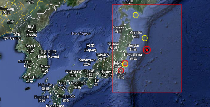
Strong earthquake with recorded magnitude 7.3 struck off the east coast of Honshu, Japan on December 7, 2012 at 08:18 UTC according to USGS and EMSC. Epicenter was located 245 km (152 miles) SE of Kamaishi, Japan and 245 km (152 miles) ESE of Ofunato, Japan. Recorded depth by USGS was 36.1 km (22.4 miles). There are no people living within 100 km.
EMSC also reported 7.3 magnitude earthquake. At this time there is slight difference in depth report. EMSC measured 40km.
A tsunami warning was issued for the coast of Miyagi Prefecture in northeastern Japan, which was hit by a devastating earthquake and tsunami in March 2011. The tsunami could be as high as six feet (1.82 m).
The mainshock is being followed by multiple strong aftershocks which go above M 6.
Shortly before the earthquake struck, NHK broke off regular programming to warn that a strong quake was due to hit. Afterward, the announcer repeatedly urged all near the coast to flee to higher ground.
More than an hour after the quake struck, an unnamed official from the Japan Meteorological Agency, speaking on national television, continued to warn people to stay away from the coast.
Immediately following the quake, there were no problems at any of the nuclear plants operated by Fukushima Dai-Ichi operator Tokyo Electric Power Co, a TEPCO spokesman, Takeo Iwamoto, said.
Takuya Taniguchi, All Nippon Airways spokesman, said government officials were checking on the runways at Sendai airport.
The two jets that were in the air went to other airports and all seven flights scheduled to go to Sendai for the day were cancelled, he said.
Important update 11:20 UTC: All Tsunami Warnings/Advisories have been cancelled.

 March 11, 2011 – Magnitude 9.0 vs December 07, 2012 – Magnitude 7.3 – location comparison
A notice to help our friends at Earthquake-report.com:
Our account @Quake_Tracker was suspended by Twitter. It has now being reopened after our Oath that we will not do anything wrong again. What? It is not our fault that a major earthquake has occurred in Japan.
The @Quake_Tracker4 remains suspended and we are requesting your help in sending twitter a notice in support of us. Thank you.
| Magnitude | 7.3 |
|---|---|
| Date-Time |
|
| Location | 37.889°N, 144.090°E |
| Depth | 36.1 km (22.4 miles) |
| Region | OFF THE EAST COAST OF HONSHU, JAPAN |
| Distances | 245 km (152 miles) SE of Kamaishi, Japan 245 km (152 miles) ESE of Ofunato, Japan 251 km (155 miles) ESE of Ishinomaki, Japan 251 km (155 miles) SE of Otsuchi, Japan |
| Location Uncertainty | horizontal +/- 13.9 km (8.6 miles); depth +/- 7 km (4.3 miles) |
| Parameters | NST=421, Nph=421, Dmin=465.3 km, Rmss=0.94 sec, Gp= 32°, M-type=regional moment magnitude (Mw), Version=9 |
| Source |
|
| Event ID | usc000e5n4 |
Tectonic Summary by USGS
Seismotectonics of Japan and Vicinity
Japan and the surrounding islands straddle four major tectonic plates: Pacific plate; North America plate; Eurasia plate; and Philippine Sea plate. The Pacific plate is subducted into the mantle, beneath Hokkaido and northern Honshu, along the eastern margin of the Okhotsk microplate, a proposed subdivision of the North America plate. Farther south, the Pacific plate is subducted beneath volcanic islands along the eastern margin of the Philippine Sea plate. This 2,200 km-long zone of subduction of the Pacific plate is responsible for the creation of the deep offshore Ogasawara and Japan trenches as well as parallel chains of islands and volcanoes, typical of Circumpacific island arcs. Similarly, the Philippine Sea plate is itself subducting under the Eurasia plate along a zone, extending from Taiwan to southern Honshu that comprises the Ryukyu Islands and the Nansei-Shoto trench.
Subduction zones at the Japanese island arcs are geologically complex and produce numerous earthquakes from multiple sources. Deformation of the overriding plates generates shallow crustal earthquakes, whereas slip at the interface of the plates generates interplate earthquakes that extend from near the base of the trench to depths of 40 to 60 km. At greater depths, Japanese arc earthquakes occur within the subducting Pacific and Philippine Sea plates and can reach depths of nearly 700 km. Since 1900, three great earthquakes occurred off Japan and three north of Hokkaido. They are the M8.4 1933 Sanriku-oki earthquake, the M8.3 2003 Tokachi-oki earthquake, the M9.0 2011 Tohoku earthquake, the M8.4 1958 Etorofu earthquake, the M8.5 1963 Kuril earthquake, and the M8.3 1994 Shikotan earthquake. More information on regional seismicity and tectonics
Aftershocks and worldwide earthquakes
Update time: Friday, December 7, 2012 at 13:05 UTC. Source: USGS
| MAG | UTC DATE-TIME |
LAT deg |
LON deg |
DEPTH km |
Region | |
|---|---|---|---|---|---|---|
| MAP | 4.7 | 2012/12/07 12:33:38 | 37.555 | 143.651 | 34.9 | OFF THE EAST COAST OF HONSHU, JAPAN |
| MAP | 2.5 | 2012/12/07 12:16:06 | 36.097 | -117.848 | 2.2 | CENTRAL CALIFORNIA |
| MAP | 5.0 | 2012/12/07 12:05:28 | 37.853 | 143.735 | 35.0 | OFF THE EAST COAST OF HONSHU, JAPAN |
| MAP | 4.6 | 2012/12/07 09:56:28 | 37.572 | 143.775 | 35.0 | OFF THE EAST COAST OF HONSHU, JAPAN |
| MAP | 4.1 | 2012/12/07 09:39:47 | 28.120 | -111.980 | 15.3 | GULF OF CALIFORNIA |
| MAP | 4.8 | 2012/12/07 09:23:04 | 37.822 | 144.175 | 35.1 | OFF THE EAST COAST OF HONSHU, JAPAN |
| MAP | 4.7 | 2012/12/07 09:13:24 | 37.721 | 143.746 | 35.1 | OFF THE EAST COAST OF HONSHU, JAPAN |
| MAP | 4.7 | 2012/12/07 09:01:54 | 37.741 | 143.543 | 35.3 | OFF THE EAST COAST OF HONSHU, JAPAN |
| MAP | 5.5 | 2012/12/07 08:48:15 | 37.849 | 143.581 | 34.8 | OFF THE EAST COAST OF HONSHU, JAPAN |
| MAP | 3.4 | 2012/12/07 08:46:35 | 58.176 | -151.278 | 50.0 | KODIAK ISLAND REGION, ALASKA |
| MAP | 6.2 | 2012/12/07 08:31:15 | 37.939 | 143.763 | 29.2 | OFF THE EAST COAST OF HONSHU, JAPAN |
| MAP | 3.1 | 2012/12/07 08:27:01 | 60.206 | -144.057 | 34.9 | SOUTHERN ALASKA |
| MAP | 7.3 | 2012/12/07 08:18:24 | 37.889 | 144.090 | 36.1 | OFF THE EAST COAST OF HONSHU, JAPAN |
Featured image: EMSC + Google Earth
Commenting rules and guidelines
We value the thoughts and opinions of our readers and welcome healthy discussions on our website. In order to maintain a respectful and positive community, we ask that all commenters follow these rules.