Massive earthquake M 7.5 struck near Alaska – Tsunami warning was in effect for Alaska and British Columbia coasts
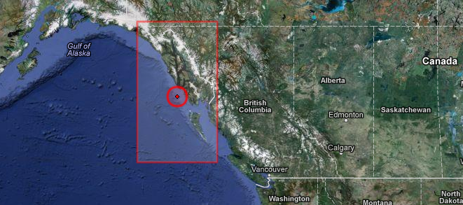
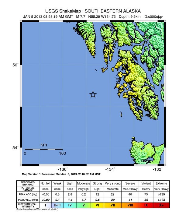
A massive earthquake magnitude 7.7 (later revised to 7.5 by USGS) was recorded near southeastern Alaska on January 05, 2013 at 8:58 UTC according to both USGS and EMSC. Epicenter was located 102 km (63 miles) W of Craig, Alaska and 303 km (188 miles) WNW of Prince Rupert, Canada at coordinates 55.292°N, 134.728°W. Recorded depth by USGS was only 9.6 km (6.0 miles). EMSC measured depth of 10 km.
GDACS is reporting that this earthquake can have a medium humanitarian impact based on the Magnitude and the affected population and their vulnerability. Only few people are living within 100 km.
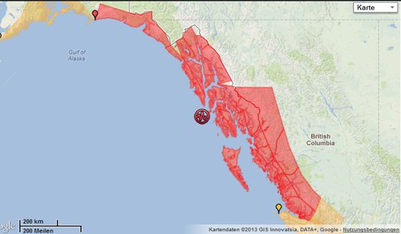
A tsunami Warning was in effect for the coastal areas of British Columbia and Alaska from the north tip of Vancouver Island, British Columbia to Cape Suckling, Alaska (75 miles SE of Cordova).
A tsunami was generated but 2 hours later NWS said it no longer poses a threat. Some areas may continue to see small sea level changes. The determination to re-occupy hazard zones must be made by local officials.
NWS-WCATWC Tsunami Cancellation Message


WEAK51 PAAQ 051058

TSUAK1


BULLETIN

PUBLIC TSUNAMI MESSAGE NUMBER 4

NWS WEST COAST/ALASKA TSUNAMI WARNING CENTER PALMER AK

1:58 AM AKST SAT JAN 5 2013


...THE TSUNAMI WARNING IS CANCELLED...


CANCELLATIONS

-------------

 * THE TSUNAMI WARNING IS CANCELED FOR THE COASTAL AREAS OF

   BRITISH COLUMBIA AND ALASKA FROM THE NORTH TIP OF VANCOUVER

   ISLAND BRITISH COLUMBIA TO CAPE FAIRWEATHER ALASKA/LOCATED

   80 MILES SE OF YAKUTAT/


IMPACTS - UPDATED

-----------------

 * A TSUNAMI WAS GENERATED DURING THIS EVENT BUT NO LONGER

   POSES A THREAT.


 * SOME AREAS MAY CONTINUE TO SEE SMALL SEA LEVEL CHANGES.


 * THE DETERMINATION TO RE-OCCUPY HAZARD ZONES MUST BE MADE BY

   LOCAL OFFICIALS.


RECOMMENDED ACTIONS - UPDATED

-----------------------------

 * DO NOT RE-OCCUPY HAZARD ZONES UNTIL LOCAL EMERGENCY OFFICIALS

   INDICATE IT IS SAFE TO DO SO.
| Magnitude | 7.7 |
|---|---|
| Date-Time |
|
| Location | 55.292°N, 134.728°W |
| Depth | 9.6 km (6.0 miles) |
| Region | SOUTHEASTERN ALASKA |
| Distances | 102 km (63 miles) W of Craig, Alaska 303 km (188 miles) WNW of Prince Rupert, Canada 335 km (208 miles) S of Juneau, Alaska 402 km (249 miles) WNW of Terrace, Canada |
| Location Uncertainty | horizontal +/- 12.3 km (7.6 miles); depth +/- 4.4 km (2.7 miles) |
| Parameters | NST=362, Nph=362, Dmin=103.5 km, Rmss=1.14 sec, Gp=130°, M-type=regional moment magnitude (Mw), Version=7 |
| Source |
|
| Event ID | usc000ejqv |
NWS-WCATWC Tsunami Warning/Advisory
WEAK51 PAAQ 050901

TSUAK1


BULLETIN

PUBLIC TSUNAMI MESSAGE NUMBER 1

NWS WEST COAST/ALASKA TSUNAMI WARNING CENTER PALMER AK

12:01 AM AKST SAT JAN 5 2013


...A TSUNAMI WARNING IS NOW IN EFFECT...


...A TSUNAMI ADVISORY IS NOW IN EFFECT...


WARNINGS/ADVISORIES/WATCHES - UPDATED

-------------------------------------

TSUNAMI WARNING IN EFFECT FOR...


 * THE COASTAL AREAS OF BRITISH COLUMBIA AND ALASKA FROM THE

   NORTH TIP OF VANCOUVER ISLAND BRITISH COLUMBIA TO CAPE

   SUCKLING ALASKA/LOCATED 75 MILES SE OF CORDOVA/


TSUNAMI ADVISORY IN EFFECT FOR...


 * THE COASTAL AREAS OF BRITISH COLUMBIA FROM THE

   WASHINGTON-BRITISH COLUMBIA BORDER TO THE NORTH TIP OF

   VANCOUVER ISLAND BRITISH COLUMBIA


 * THE COASTAL AREAS OF ALASKA FROM CAPE SUCKLING

   ALASKA/LOCATED 75 MILES SE OF CORDOVA/ TO KENNEDY ENTRANCE

   ALASKA/LOCATED 40 MILES SW OF HOMER/


PRELIMINARY EARTHQUAKE PARAMETERS

---------------------------------

 * MAGNITUDE      7.7

 * ORIGIN TIME    2358 AKST JAN 04 2013

                  0058  PST JAN 05 2013

                  0858  UTC JAN 05 2013

 * COORDINATES    55.3 NORTH 134.9 WEST

 * DEPTH          3 MILES

 * LOCATION       90 MILES NW OF DIXON ENTRANCE ALASKA

                  210 MILES S OF JUNEAU ALASKA


IMPACTS FOR TSUNAMI WARNING AREAS

---------------------------------

 * A TSUNAMI WITH SIGNIFICANT WIDESPREAD INUNDATION OF LAND IS

   EXPECTED.


 * WIDESPREAD DANGEROUS COASTAL FLOODING ACCOMPANIED BY POWERFUL

   CURRENTS IS POSSIBLE AND MAY CONTINUE FOR MANY HOURS AFTER

   TSUNAMI ARRIVAL.


 * THE FIRST WAVE MAY NOT BE THE LARGEST.


IMPACTS FOR TSUNAMI ADVISORY AREAS

----------------------------------

 * A TSUNAMI CAPABLE OF PRODUCING STRONG CURRENTS OR WAVES DANGEROUS

   TO PERSONS IN OR VERY NEAR THE WATER IS EXPECTED.


 * CURRENTS MAY BE HAZARDOUS TO SWIMMERS... BOATS... AND COASTAL

   STRUCTURES AND MAY CONTINUE FOR MANY HOURS AFTER THE TSUNAMI

   ARRIVAL.


 * THE FIRST WAVE MAY NOT BE THE LARGEST.


RECOMMENDED ACTIONS - UPDATED

-----------------------------

 * IF YOU ARE IN A WARNING AREA - MOVE INLAND TO HIGHER GROUND.


 * IF YOU ARE IN AN ADVISORY AREA - MOVE OFF THE BEACH AND OUT OF

   HARBORS AND MARINAS.  WIDESPREAD INUNDATION OF LAND IS NOT

   EXPECTED FOR ADVISORY AREAS.


 * BE ALERT TO INSTRUCTIONS FROM YOUR LOCAL EMERGENCY OFFICIALS.


 * DO NOT GO TO THE COAST TO OBSERVE THE TSUNAMI.


 * DO NOT RETURN TO THE COAST UNTIL LOCAL EMERGENCY OFFICIALS

   INDICATE IT IS SAFE TO DO SO.


FORECASTS AND/OR OBSERVATIONS OF TSUNAMI ACTIVITY

-------------------------------------------------

                 FORECAST

                 START OF

SITE             OF TSUNAMI

----             ----------


 * BRITISH COLUMBIA

LANGARA          0129  PST JAN  5

TOFINO           0314  PST JAN  5


 * ALASKA

SITKA            0045 AKST JAN  5

ELFIN COVE       0056 AKST JAN  5

CRAIG            0113 AKST JAN  5

YAKUTAT          0145 AKST JAN  5

SEWARD           0224 AKST JAN  5

VALDEZ           0238 AKST JAN  5

CORDOVA          0247 AKST JAN  5

HOMER            0338 AKST JAN  5
Alaskan tsunamis in history
During the past century, four large and well documented tsunamis were generated in the waters off the Alaskan coast. These include the 1946 and 1957 Aleutian events, the 1958 Lituya Bay event, and the 1964 Alaskan event. While all four tsunamis were produced by seismic activity, the intensities, processes of generation (ie. landslide vs. tectonic), and areas of affected coastline differ for each.
During the early morning of April 1, 1946, an earthquake of magnitude 7.4 occurred in an area of the Aleutian Trench located approximately 90 miles south of Unimak Island, part of the Aleutian Island chain (see diagram above for approximate location of quake’s epicenter). During the quake, a large section of seafloor was uplifted along the fault where the quake occurred, producing a large, Pacific-wide tectonic tsunami. The most detailed, and well documented accounts of the 1946 Aleutian tsunami come from Scotch Cap, located on Unimak Island, and the Hawaiian Islands. Despite its enormous size at Scotch Cap, the 1946 tsunami had little effect on the Alaskan mainland, due to the presence of the Aleutian Islands, which absorbed the brunt of the tsunami’s power, shielding the mainland.
During the early morning hours of March 9, 1957, a magnitude 8.3 earthquake struck along a section of the Aleutian Trench located south of the Andreanof Islands (the section of the Aleutian Islands shown above). The vertical seafloor displacement that accompanied this quake generated a major Pacific-wide tectonic tsunami, similar to the 1946 Aleutian event, but fortunately smaller. The 1957 event is not as well documented as that of 1946, which is probably do to the fact that it struck hardest at the sparsely populated Aleutian Islands, while more populated areas, such as Hawaii and California, received smaller waves.
Lituya Bay, located within Glacier Bay National Park, along Alaska’s southeastern coast (see map above), was the site of one of the largest local tsunamis ever recorded. On the night of July 7, 1958, a magnitude 8.0 earthquake occurred along the Fairweather Fault, the trace of which runs along the far northwestern portion of the bay. The epicenter of this quake was a scant 13 miles from Lityua Bay. The earthquake caused a large landslide in the bay, which produced a local tsunami of frightening size.
During the evening of March 27, 1964 (good Friday!), the area of Prince William Sound, in Southeastern Alaska (see figure above), was struck by a moment magnitude 9.2 earthquake, the largest ever recorded in North America. The quake was accompanied by large vertical displacements over an approximate 200,000 square mile area along the source fault, much of this beneath Prince William Sound. This vertical displacement generated a major tectonic tsunami that struck the southeast coast of Alaska, the Pacific Coast of British Columbia, and west coast of the United States. In addition to the tectonic tsunami, the violent shaking during the earthquake caused many large landslides and submarine slumps, which in turn produced destructive local tsunamis at many locations along the Alaskan coast. Due to the orientation of the fault that generated the tsunami, the largest waves outside of Alaska, occurred along the northwest Pacific coasts of Canada and the United States. Read more on Alaskan tsunamis here.
Featured image: EMSC + Google Maps
Commenting rules and guidelines
We value the thoughts and opinions of our readers and welcome healthy discussions on our website. In order to maintain a respectful and positive community, we ask that all commenters follow these rules:
We reserve the right to remove any comments that violate these rules. By commenting on our website, you agree to abide by these guidelines. Thank you for helping to create a positive and welcoming environment for all.