Active volcanoes in the world: February 13 – February 19, 2013
This week, 8 volcanoes were noticed to have new activity, whereas ongoing activity was reported for 14 volcanoes. This report covers active volcanoes in the world recorded from February 13 – February 19, 2013 based on Smithsonian/USGS criteria.
New activity/unrest: | Barren Island, Andaman Islands | Cleveland, Chuginadak Island | Etna, Sicily (Italy) | Grozny Group, Iturup Island | Pacaya, Guatemala | Paluweh, Lesser Sunda Islands (Indonesia) | Soufrière Hills, Montserrat | Stromboli, Aeolian Islands (Italy)
Ongoing activity: | Bagana, Bougainville | Batu Tara, Komba Island (Indonesia) | Chirpoi, Kuril Islands (Russia) | Fuego, Guatemala | Karymsky, Eastern Kamchatka (Russia) | Kilauea, Hawaii (USA) | Kizimen, Eastern Kamchatka (Russia) | Manam, Northeast of New Guinea (SW Pacific) | Pagan, Mariana Islands | Popocatépetl, México | Sakura-jima, Kyushu | Shiveluch, Central Kamchatka (Russia) | Tolbachik, Central Kamchatka (Russia) | Tongariro, North Island (New Zealand)
The Weekly Volcanic Activity Report is a cooperative project between the Smithsonian’s Global Volcanism Program and the US Geological Survey’s Volcano Hazards Program. Updated by 2300 UTC every Wednesday, notices of volcanic activity posted on these pages are preliminary and subject to change as events are studied in more detail. This is not a comprehensive list of all of Earth’s volcanoes erupting during the week, but rather a summary of activity at volcanoes that meet criteria discussed in detail in the “Criteria and Disclaimers” section. Carefully reviewed, detailed reports on various volcanoes are published monthly in the Bulletin of the Global Volcanism Network.
New activity/unrest
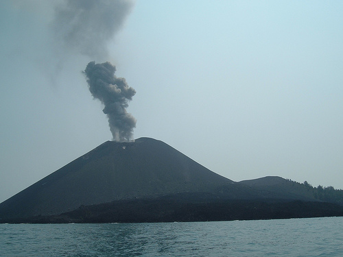
BARREN ISLAND, Andaman Islands
12.278°N, 93.858°E; summit elev. 354 m
Based on analysis of satellite imagery and wind data, the Darwin VAAC reported that on 16 February an ash plume from Barren Island rose to an altitude of 6.1 km (20,000 ft) a.s.l. and drifted 220 km SW.
Geologic summary. Barren Island, a possession of India in the Andaman Sea about 135 km NE of Port Blair in the Andaman Islands, is the only historically active volcano along the N-S-trending volcanic arc extending between Sumatra and Burma (Myanmar). The 354-m-high island is the emergent summit of volcano that rises from a depth of about 2,250 m. The small, uninhabited 3-km-wide island contains a roughly 2-km-wide caldera with walls 250-350 m high. The caldera, which is open to the sea on the W, was created during a major explosive eruption in the latePleistocene that produced pyroclastic-flow and -surge deposits. The morphology of a fresh pyroclastic cone that was constructed in the center of the caldera has varied during the course of historical eruptions. Lava flows fill much of the caldera floor and have reached the sea along the western coast during historical eruptions.
CLEVELAND, Chuginadak Island
52.825°N, 169.944°W; summit elev. 1730 m
AVO reported that during 12-15 February elevated surface temperatures from Cleveland’s lava dome were detected in satellite images. Clouds obscured views of the dome during 16-19 February. The Volcanic Alert Levelremained at Watch and the Aviation Color Code remained at Orange.
Geologic summary. Symmetrical Mount Cleveland stratovolcano is situated at the western end of the uninhabited dumbbell-shaped Chuginadak Island in the east-central Aleutians. The 1,730-m-high stratovolcano is the highest of the Islands of Four Mountains group and is one of the most active in the Aleutians. Numerous large lava flows descend its flanks. It is possible that some 18th to 19th century eruptions attributed to Carlisle (a volcano located across the Carlisle Pass Strait to the NW) should be ascribed to Cleveland. In 1944 Cleveland produced the only known fatality from an Aleutian eruption. Recent eruptions from Mt. Cleveland have been characterized by short-lived explosive ash emissions, at times accompanied by lava fountaining and lava flows down the flanks.
ETNA, Sicily (Italy)
37.734°N, 15.004°E; summit elev. 3330 m
Sezione di Catania – Osservatorio Etneo reported that during the evenings of 13 and 14 February a camera recorded incandescence from Etna’s New Southeast Crater (NSEC). In the early hours of 15 February incandescent bombs were ejected just higher than the crater rim. Strombolian activity gradually intensified on 17 February along with volcanic tremor amplitude. Small Strombolian explosions occurred every 1-2 seconds at daybreak, launching coarse-grained pyroclastic material a few tens of meters above the crater rim. After reaching a peak around 0700, activity started to diminish; a few hours later, the volcanic tremor amplitude returned to background levels, and by the evening there was no sign of eruptive activity.
Shortly before midnight on 18 February, the clouds dissipated from the summit area, revealing continuous weakStrombolian activity within NSEC. During 0000-0200 on 19 February the volcanic tremor amplitude rose gradually, then distinctly increased after 0200. Contemporaneously, the eruptive activity started to intensify from one vent in the center of the crater. About 10 minutes later, lava started to overflow through the deep notch in the SE crater rim, expanding slowly toward the steep W slope of the Valle del Bove. At 0457 the small pit crater that had formed on the SW rim of the NSEC on 27 August 2012 started to emit ash, and repeated rim collapses generated small landslides. Activity of the main vent within the crater rapidly increased, and at 0503 a lava fountain rose about 200 m above the summit of the cone.
During the interval from 0503 until 0507, several vents became active along a fracture from the pit crater to the notch in the SE crater rim. A dense cloud of ash rose and drifted E. Next, the entire NSEC cone was subjected to heavy fallout of coarse-grained pyroclastic material. The main lava flow advanced SE, and a small lava flow that developed on the flank below the pit crater traveled along the March 2012 fracture zone between the old and new SEC cones. At 0515 lava fountains rose 300-500 m above the crater rim and produced bombs and spatter that covered the S flank of the cone. Small avalanches of this incandescent material generated ash clouds. During 0516-0518 the S flank of the cone was veiled by a dense curtain of fallout from the lava fountains. At the same time, dense vapor clouds rose from the upper E flank of Etna, generated by the copious fallout of incandescent pyroclastic material onto the snow.
At 0519, a more substantial avalanche of fresh material detached from the S flank of the cone, generating a smallpyroclastic flow that expanded a few hundred meters first S and then E. At 0536 a thermal monitoring camera recorded a lahar from near the Belvedere area, which was followed by a broad lava flow that descended the steep slope and reached the base after less than 20 minutes. During its descent, the lava continued to melt snow, producing numerous small lahars. At 0550 a second lava flow N of the first also generated lahars. Finally, at about 0600, a third lava flow, which generated a lahar, descended the W slope of the Valle del Bove to the S of the first flow.
Lava fountaining from the pit crater started to diminish around 0525, and at 0535 transitioned into ash emissions alternating with brief jets of incandescent lava. At 0545, one single vent, in the central portion of the NSEC, continued to produce lava fountains about 200 m high. A few minutes later, however, a new lava flow started to descend the lower SE flank of the cone, possibly after the opening of a new eruptive vent in the lower part of the notch cutting that sector of the cone. Surveillance cameras showed brief lava fountaining at that site, before all lava fountaining ceased shortly before 0600. During the interval between 0600 and 0615, the activity was characterized by emission of a dense ash plume with frequent jets of lava and powerful explosions, which launched large glowing bombs beyond the summit of the old Southeast Crater cone. After 0615 only ash emission persisted. At 0622 a puff of ash was emitted from the Bocca Nuova; shortly thereafter, ash emissions from the NSEC diminished notably and became discontinuous; the last, weak puffs of ash were observed around 0710. Slow lava emissions continued for a few more hours from the lowermost vent, which had opened shortly after 0547 on the SE flank of the cone. During the late afternoon of 19 February, small ash puffs were again emitted from the Bocca Nuova. Tephra fell in a narrow area extending from the NSEC towards the E, including Milo and Fornazzo (10 km E), Giarre (16 km E) and Riposto (18 km E).
Geologic summary. Mount Etna, towering above Catania, Sicily’s second largest city, has one of the world’s longest documented records of historical volcanism, dating back to 1500 BC. Historical lava flows cover much of the surface of this massive basaltic stratovolcano, the highest and most voluminous in Italy. Two styles of eruptive activity typically occur at Etna. Persistent explosive eruptions, sometimes with minor lava emissions, take place from one or more of the three prominent summit craters, the Central Crater, NE Crater, and SE Crater. Flank eruptions, typically with higher effusion rates, occur less frequently and originate from fissures that open progressively downward from near the summit. A period of more intense intermittent explosive eruptions from Etna’s summit craters began in 1995. The active volcano is monitored by the Instituto Nazionale di Geofisica e Volcanologia (INGV) in Catania.
GROZNY GROUP, Iturup Island
45.026°N, 147.922°E; summit elev. 1211 m
Based on visual observations, SVERT reported that on 16 February an ash-and-gas plume from Grozny Group rose 3 km a.s.l. The Aviation Color Code was raised to Yellow.
Geologic summary. The Grozny volcano group in central Iturup Island contains the complex volcanoes of Ivan Grozny and Tebenkov. The former has a 3-3.5 km diameter caldera that is open to the south, where the large, 1158-m-high andesitic Grozny extrusion dome (also known as Etorofu-Yake-yama) was emplaced. Several other lava domes of Holocene age were constructed to the NE; extrusion of these domes has constricted a former lake in the northern side of the caldera to an extremely sinuous shoreline. The forested andesitic Tebenkov volcano, also known as Odamoi-san, lies immediately to the NE of the Grozny dome complex. The large Machekh crater, which displays strong fumarolic activity, lies immediately south of Tebenkov. Historical eruptions, the first of which took place in 1968, have been restricted to Ivan Grozny.
PACAYA, Guatemala
14.381°N, 90.601°W; summit elev. 2552 m
Based on INSIVUMEH notices, CONRED reported that explosions at Pacaya detected on 13 February were accompanied by rumbling. No material was ejected. The next day a diffuse white plume rose 200 m and drifted W and SW. Rumbling was heard in San Francisco de Sales (5 km N) and San Vicente Pacaya (5 km NW).
Geologic summary. Eruptions from Pacaya, one of Guatemala’s most active volcanoes, are frequently visible from Guatemala City, the nation’s capital. Pacaya is a complex volcano constructed on the southern rim of the 14 x 16 kmPleistocene Amatitlan caldera. A cluster of dacitic lava domes occupies the caldera floor. The Pacaya massif includes the Cerro Grande lava dome and a younger volcano to the SW. Collapse of Pacaya volcano about 1,100 years ago produced a debris-avalanche deposit that extends 25 km onto the Pacific coastal plain and left an arcuate somma rim inside which the modern Pacaya volcano (MacKenney cone) grew. During the past several decades, activity at Pacaya has consisted of frequent Strombolian eruptions with intermittent lava flow extrusion on the flanks of MacKenney cone, punctuated by occasional larger explosive eruptions.
PALUWEH, Lesser Sunda Islands (Indonesia)
8.32°S, 121.708°E; summit elev. 875 m
CVGHM reported that activity at Paluweh during October 2012-January 2013 was characterized by lava-domegrowth, incandescent avalanches, pyroclastic flows, ash plumes that rose as high as 4 km above the dome, and ejected material deposited 3 km away. The whole island was affected by ashfall, which was an average of 2 cm thick on some areas. Some infrastructure and several homes were damaged by ash and lahars.
On 1 February at 1652 an eruption generated an ash plume that rose 2 km. Pyroclastic flows and avalanches were observed. On 2 February an explosion produced an ash plume that rose 4 km and was accompanied by booms and rumbling. The ash plume drifted S and deposited ashfall up to 1 mm thick in Ende (60 km S); thick ashfall was reported in Ona (SE part of the island) and thin deposits were reported in other areas of the island to the W, N, and E. About 25% of the S portion of the dome was lost; the lava-dome volume was an estimated 5.1 million cubic meters on 13 January. On 3 February an ash eruption was observed as well as incandescence from the crater. During 4-10 February diffuse white plumes rose 50-100 m. The Alert Level remained at 3 (on a scale of 1-4), and visitors and residents were prohibited from approaching the crater within a 3-km-radius.
Based on analyses of satellite imagery and wind data, the Darwin VAAC reported that during 17-18 February ashplumes rose to an altitude of 7 km (13,000 ft) a.s.l. and drifted 75 km E and NE.
Geologic summary. Paluweh volcano, also known as Rokatenda, forms the 8-km-wide island of Paluweh N of the volcanic arc that cuts across Flores Island. Although the volcano rises about 3,000 m above the sea floor, its summit reaches only 875 m above sea level. The broad irregular summit region contains overlapping craters up to 900 m wide and several lava domes. Several flank vents occur along a NW-trending fissure. The largest historical eruption of Paluweh occurred in 1928, when a strong explosive eruption was accompanied by landslide-induced tsunamis and lava-dome emplacement.
SOUFRIERE HILLS, Montserrat
16.72°N, 62.18°W; summit elev. 915 m
MVO reported that during 8-15 February activity at the Soufrière Hills lava dome was at a low level, although sulfur dioxide gas flux remained elevated following the activity during 3-6 February. The seismic network recorded one rockfall and one volcano-tectonic earthquake. The Hazard Level remained at 2 (on a scale of 1-5).
Geologic summary. The complex dominantly andesitic Soufrière Hills volcano occupies the southern half of the island of Montserrat. The summit area consists primarily of a series of lava domes emplaced along an ESE-trending zone. English’s Crater, a 1-km-wide crater breached widely to the E, was formed during an eruption about 4,000 years ago in which the summit collapsed, producing a large submarine debris avalanche. Block-and-ash flow and surge deposits associated with dome growth predominate in flank deposits at Soufrière Hills. Non-eruptive seismic swarms occurred at 30-year intervals in the 20th century, but with the exception of a 17th-century eruption that produced the Castle Peak lava dome, no historical eruptions were recorded on Montserrat until 1995. Long-term small-to-moderate ash eruptions beginning in that year were later accompanied by lava-dome growth andpyroclastic flows that forced evacuation of the southern half of the island and ultimately destroyed the capital city of Plymouth, causing major social and economic disruption.
STROMBOLI, Aeolian Islands (Italy)
38.789°N, 15.213°E; summit elev. 924 m
Sezione di Catania – Osservatorio Etneo reported that a new phase of intermittent effusive activity at Stromboli, which consisted of small overflows of lava from the crater terrace, began on 8 February and continued until the morning of 17 February. During this interval several episodes of effusive activity occurred in the N and NW sectors of the Sciara del Fuoco, producing lava flows that traveled several tens to a few hundred meters.
Lava overflows ceased on the afternoon of 10 February, but effusive activity resumed in the early morning hours of the next day. On the afternoon of 11 February, three small lava flows were visible on the upper slope of the Sciara del Fuoco; the westernmost flow traveled a few hundred meters. That evening two of these flows remained active and continued to be fed until the morning of 12 February. The more westerly of the flows then stopped, whereas the flow traveling N continued until the early afternoon.
After an interval of non-visibility due to inclement weather conditions, a new lava flow traveled NW in the evening of 12 February. This flow progressively diminished, but was still active at about 1100 on 13 February.
The vent N2, perched on the NW rim of the crater terrace, produced continuous spattering, which also fed a smalllava flow parallel to the already active flow. Spattering continued for a few hours, and then diminished during the late afternoon of 14 February. Subsequently, effusive activity diminished considerably, and only very small lava overflows extended a few tens of meters NW. In the morning of 17 February, all effusive activity ceased and mild Strombolianactivity resumed.
Geologic summary. Spectacular incandescent nighttime explosions at Stromboli volcano have long attracted visitors to the “Lighthouse of the Mediterranean.”Stromboli, the NE-most of the Aeolian Islands, has lent its name to the frequent mild explosive activity that has characterized its eruptions throughout historical time. The small, 926-m-high island of Stromboli is the emergent summit of a volcano that grew in two main eruptive cycles, the last of which formed the western portion of the island. The active summit vents are located at the head of the Sciara del Fuoco, a horseshoe-shaped scarp formed as a result of slope failure that extends to below sea level and funnels pyroclastic ejecta and lava flows to the NW. Essentially continuous mild Strombolian explosions, sometimes accompanied by lava flows, have been recorded at Stromboli since Roman times.
Ongoing activity
BAGANA, Bougainville
6.140°S, 155.195°E; summit elev. 1750 m
Based on analyses of satellite imagery and wind data, the Darwin VAAC reported that during 12-14 February ashplumes from Bagana rose to an altitude of 1.5 km (5,000 ft) a.s.l. and drifted 35-55 km SW and NW.
Geologic summary. Bagana volcano, occupying a remote portion of central Bougainville Island, is one of Melanesia’s youngest and most active volcanoes. Bagana is a massive symmetrical lava cone largely constructed by an accumulation of viscous andesitic lava flows. The entire lava cone could have been constructed in about 300 years at its present rate of lava production. Eruptive activity at Bagana is characterized by non-explosive effusion of viscous lava that maintains a small lava dome in the summit crater, although explosive activity occasionally producing pyroclastic flows also occurs. Lava flows form dramatic, freshly preserved tongue-shaped lobes up to 50-m-thick with prominent levees that descend the volcano’s flanks on all sides.
BATU TARA, Komba Island (Indonesia)
7.792°S, 123.579°E; summit elev. 748 m
Based on analyses of satellite imagery and wind data, the Darwin Volcanic Ash Advisory Centre (VAAC) reported that on 13 February ash plumes from Batu Tara rose to altitudes of 2.1 km (7,000 ft) a.s.l. and drifted over 35 km N. On 18 February ash plumes rose to an altitude of 1.5 km (5,000 ft) a.s.l. and drifted 37 km NE.
Geologic summary. The small isolated island of Batu Tara in the Flores Sea about 50 km north of Lembata (formerly Lomblen) Island contains a scarp on the eastern side similar to the Sciara del Fuoco of Italy’s Stromboli volcano. Vegetation covers the flanks of Batu Tara to within 50 m of the 748-m-high summit. Batu Tara lies north of the main volcanic arc and is noted for its potassic leucite-bearing basanitic and tephritic rocks. The first historicaleruption from Batu Tara, during 1847-52, produced explosions and a lava flow.
CHIRPOI, Kuril Islands (Russia)
46.525°N, 150.875°E; summit elev. 742 m
SVERT reported that a thermal anomaly and weak steam-and-gas emissions from Snow, a volcano of Chirpoi, were detected in satellite images during 14-15 February; cloud cover prevented observations of the volcano on other days during 11-18 February. The Aviation Color Code was Yellow.
Geologic summary. Chirpoi, a small island lying between the larger islands of Simushir and Urup, contains a half dozen volcanic edifices constructed within an 8-9 km wide, partially submerged caldera. The southern rim of thecaldera is exposed on nearby Brat Chirpoev Island. Two volcanoes on Chirpoi Island have been historically active. The symmetrical Cherny volcano, which forms the 691 m high point of the island, erupted twice during the 18th and 19th centuries. The youngest volcano, Snow, originated between 1770 and 1810. It is composed almost entirely oflava flows, many of which have reached the sea on the southern coast. No historical eruptions are known from 742-m-high Brat Chirpoev, but its youthful morphology suggests recent strombolian activity.
FUEGO, Guatemala
14.473°N, 90.880°W; summit elev. 3763 m
INSIVUMEH reported that during 14-15 February white plumes rose 150 m above Fuego’s crater and drifted W and NW. The lava flow traveled 500 m SSW down the Ceniza drainage and produced avalanches. Activity increased on the night of 16 February and was characterized by explosions, pyroclastic flows, and lava flows. A pyroclastic flowtraveled 3 km down the Ceniza drainage. Ash plumes drifted 20 km W and SW, and produced ashfall in Panimache I and Panimache II (8 KM SW), Morelia (9 km SW), Santa Sofía (12 km SW), Sangre de Cristo (8 km WSW), and Yepocapa (8 km WNW). On 17 February collapses from the lava-flow fronts and pyroclastic flows were observed. Ash plumes rose 3 km and drifted 10 km W and SW. Seismicity decreased. According to the Washington VAACash plumes detected in satellite imagery drifted 19 km W, 10 km SW, and 5 km S. INSIVUMEH noted that lava effusion continued and ash fell on the flanks. On 18 February an explosion generated an ash plume that rose 2 km above the crater and drifted 10 km NE. Two other explosions produced ash plumes that rose 500-800 m. Avalanches traveled S and W.
Geologic summary. Volcán Fuego, one of Central America’s most active volcanoes, is one of three largestratovolcanoes overlooking Guatemala’s former capital, Antigua. The scarp of an older edifice, Meseta, lies between 3,763-m-high Fuego and its twin volcano to the N, Acatenango. Construction of Meseta volcano continued until the late Pleistocene or early Holocene, after which growth of the modern Fuego volcano continued the southward migration of volcanism that began at Acatenango. Frequent vigorous historical eruptions have been recorded at Fuego since the onset of the Spanish era in 1524, and have produced major ashfalls, along with occasional pyroclastic flows and lava flows. The last major explosive eruption from Fuego took place in 1974, producing spectacular pyroclastic flows visible from Antigua.
KARYMSKY, Eastern Kamchatka (Russia)
54.05°N, 159.45°E; summit elev. 1536 m
KVERT reported that moderate seismic activity at Karymsky was detected during 8-15 February. Possible ashexplosions on 11 February produced an ash plume that rose 3.2 km (10,500 ft) a.s.l. Satellite imagery showed a thermal anomaly on the volcano during 12-13 February. The Aviation Color Code remained at Orange.
Geologic summary. Karymsky, the most active volcano of Kamchatka’s eastern volcanic zone, is a symmetricalstratovolcano constructed within a 5-km-wide caldera that formed about 7,600-7,700 radiocarbon years ago. Construction of the Karymsky stratovolcano began about 2,000 years later. The latest eruptive period began about 500 years ago, following a 2,300-year quiescence. Much of the cone is mantled by lava flows less than 200 years old. Historical eruptions have been Vulcanian or Vulcanian-Strombolian with moderate explosive activity and occasional lava flows from the summit crater. Most seismicity preceding Karymsky eruptions has originated beneath Akademia Nauk caldera, which is located immediately S of Karymsky volcano and erupted simultaneously with Karymsky in 1996.
KILAUEA, Hawaii (USA)
19.421°N, 155.287°W; summit elev. 1222 m
During 13-19 February HVO reported that the circulating lava lake periodically rose and fell in the deep pit within Kilauea’s Halema’uma’u Crater. The plume from the vent continued to deposit variable amounts of ash, spatter, andPele’s hair onto nearby areas. The lake level was between 25-30 m below the Halema’uma’u crater floor during 13 and 15-17 February.
At Pu’u ‘O’o Crater, glow emanated from spatter cones on the SE part of the crater floor, from a spatter cone at the NW edge of the floor, and from a perched crusted lava lake on the NE part of the floor. Lava flowed from the SE and S spatter cones on 13 February and from the SW cone on 17 February. On 19 February lava flowed from the SW and NE spatter cones. New breakouts occurred on the Kahauale’a lava tube high on the NE flank of Pu’u ‘O’o cone.
Multiple lava flows, collectively called the Kahauale’a flow, from the lava lake (perched 5-6 m higher than the crater rim) traveled across the NE flank of Pu’u ‘O’o cone to the cone’s base and continued to advance N and E over older flows. Lava flows were active above the pali (5 km SE of Pu’u ‘O’o) and in a 1-km-wide area on the coastal plain. To the W, a 350-m-wide lava flow advanced towards the coast and produced scattered breakouts. Web cameras recorded steam plumes from lava sporadically entering the ocean at multiple locations.
Geologic summary. Kilauea, one of five coalescing volcanoes that comprise the island of Hawaii, is one of the world’s most active volcanoes. Eruptions at Kilauea originate primarily from the summit caldera or along one of the lengthy E and SW rift zones that extend from the caldera to the sea. About 90% of the surface of Kilauea is formed of lava flows less than about 1,100 years old; 70% of the volcano’s surface is younger than 600 years. A long-term eruption from the East rift zone that began in 1983 has produced lava flows covering more than 100 sq km, destroying nearly 200 houses and adding new coastline to the island.
KIZIMEN, Eastern Kamchatka (Russia)
55.130°N, 160.32°E; summit elev. 2376 m
KVERT reported that during 8-15 February moderate seismic activity continued at Kizimen. Video data showed thatlava continued to extrude from the summit, producing summit incandescence, strong gas-and-steam activity, and hot avalanches on the W and E flanks. Satellite images detected a daily thermal anomaly over the volcano. TheAviation Color Code remained at Orange.
Geologic summary. Kizimen is an isolated, conical stratovolcano that is morphologically similar to Mount St. Helens prior to its 1980 eruption. The summit of Kizimen consists of overlapping lava domes, and blocky lava flows descend the flanks of the volcano, which is the westernmost of a volcanic chain north of Kronotsky volcano. The 2,376-m-high Kizimen was formed during four eruptive cycles beginning about 12,000 years ago and lasting 2,000-3,500 years. The largest eruptions took place about 10,000 and 8300-8400 years ago, and three periods of longterm lava-dome growth have occurred. The latest eruptive cycle began about 3,000 years ago with a large explosion and was followed by lava-dome growth lasting intermittently about 1,000 years. An explosive eruption about 1,100 years ago produced a lateral blast and created a 1.0 x 0.7 km wide crater breached to the NE, inside which a small lava dome (the fourth at Kizimen) has grown. A single explosive eruption, during 1927-28, has been recorded in historical time.
MANAM, Northeast of New Guinea (SW Pacific)
4.080°S, 145.037°E; summit elev. 1807 m
Based on observations of satellite imagery and wind data analyses, the Darwin VAAC reported that an ash plume from Manam was observed on 12 February at an altitude of 10.1 km (33,000 ft) a.s.l. On 16 February an ash plume rose to an altitude of 3.4 km (11,000 ft) a.s.l. and drifted over 35 km NW.
Geologic summary. The 10-km-wide island of Manam, lying 13 km off the northern coast of mainland Papua New Guinea, is one of the country’s most active volcanoes. Four large radial valleys extend from the unvegetated summit of the conical 1807-m-high basaltic-andesitic stratovolcano to its lower flanks. These “avalanche valleys,” regularly spaced 90 degrees apart, channel lava flows and pyroclastic avalanches that have sometimes reached the coast. Two summit craters are present; both are active, although most historical eruptions have originated from the southern crater, concentrating eruptive products during much of the past century into the SE avalanche valley. Frequent historical eruptions, typically of mild-to-moderate scale, have been recorded at Manam since 1616. Occasional larger eruptions have produced pyroclastic flows and lava flows that reached flat-lying coastal areas and entered the sea, sometimes impacting populated areas.
PAGAN, Mariana Islands
18.13°N, 145.80°E; summit elev. 570 m
Satellite imagery showed a plume of gas and water vapor drifting 240 km downwind from Pagan daily during 9-15 February. A USGS team that visited Pagan on 9 February observed a continuous, vigorous plume and noted a sulfur odor downwind of the summit.
Geologic summary. Pagan Island, the largest and one of the most active of the Mariana Islands volcanoes, consists of two stratovolcanoes connected by a narrow isthmus. Both North and South Pagan stratovolcanoes were constructed within calderas, 7 and 4 km in diameter, respectively. The 570-m-high Mount Pagan at the NE end of the island rises above the flat floor of the caldera, which probably formed during the early Holocene. South Pagan is a 548-m-high stratovolcano with an elongated summit containing four distinct craters. Almost all of the historicaleruptions of Pagan, which date back to the 17th century, have originated from North Pagan volcano. The largest eruption of Pagan during historical time took place in 1981 and prompted the evacuation of the sparsely populated island.
POPOCATEPETL, México
19.023°N, 98.622°W; summit elev. 5426 m
CENAPRED reported that during 13-19 February seismicity at Popocatépetl indicated continuing gas-and-steam emissions. Incandescence from the crater was observed at night. Observers reported that gas-and-steam plumes drifted NE, E, and SE; a plume rose 1.2 km above the crater on 19 February. During 18-19 February the emissions possibly contained ash. The Alert Level remained at Yellow, Phase Two.
Geologic summary. Popocatépetl, whose name is the Aztec word for smoking mountain, towers to 5,426 m 70 km SE of Mexico City and is North America’s second-highest volcano. Frequent historical eruptions have been recorded since the beginning of the Spanish colonial era. A small eruption on 21 December 1994 ended five decades of quiescence. Since 1996 small lava domes have incrementally been constructed within the summit crater and destroyed by explosive eruptions. Intermittent small-to-moderate gas-and-ash eruptions have continued, occasionally producing ashfall in neighboring towns and villages.
SAKURA-JIMA, Kyushu
31.585°N, 130.657°E; summit elev. 1117 m
JMA reported that during 12-15 February 16 explosions from Sakura-jima’s Showa Crater were detected and ejected tephra fell at most 1.3 km from the crater. Crater incandescence was clearly detected at night.
Based on information from JMA, explosions from Sakura-jima’s Showa Crater during 13-18 February generated plumes that rose to altitudes of 1.2-3 km (4,000-10,000 ft) a.s.l. and drifted in multiple directions. The Tokyo VAACreported that pilots observed ash plumes at altitudes of 1.8-3 km (6,000-10,000 ft) a.s.l. during 13 and 15-16 February.
Geologic summary. Sakura-jima, one of Japan’s most active volcanoes, is a post-caldera cone of the Aira calderaat the northern half of Kagoshima Bay. Eruption of the voluminous Ito pyroclastic flow was associated with the formation of the 17 x 23-km-wide Aira caldera about 22,000 years ago. The construction of Sakura-jima began about 13,000 years ago and built an island that was finally joined to the Osumi Peninsula during the major explosive and effusive eruption of 1914. Activity at the Kita-dake summit cone ended about 4,850 years ago, after which eruptions took place at Minami-dake. Frequent historical eruptions, recorded since the 8th century, have depositedash on Kagoshima, one of Kyushu’s largest cities, located across Kagoshima Bay only 8 km from the summit. The largest historical eruption took place during 1471-76.
SHIVELUCH, Central Kamchatka (Russia)
56.653°N, 161.360°E; summit elev. 3283 m
Based on visual observations and analyses of satellite data, KVERT reported that during 8-15 February a viscouslava flow effused on the E flank of Shiveluch’s lava dome, accompanied by hot avalanches, incandescence, andfumarolic activity. Satellite imagery showed a daily thermal anomaly on the lava dome. The Aviation Color Coderemained at Orange.
Geologic summary. The high, isolated massif of Shiveluch volcano (also spelled Sheveluch) rises above the lowlands NNE of the Kliuchevskaya volcano group and forms one of Kamchatka’s largest and most active volcanoes. The currently active Molodoy Shiveluch lava-dome complex was constructed during the Holocene within a large breached caldera formed by collapse of the massive late-Pleistocene Strary Shiveluch volcano. At least 60 large eruptions of Shiveluch have occurred during the Holocene, making it the most vigorous andesitic volcano of the Kuril-Kamchatka arc. Frequent collapses of lava-dome complexes, most recently in 1964, have produced large debris avalanches whose deposits cover much of the floor of the breached caldera. Intermittent explosive eruptions began in the 1990s from a new lava dome that began growing in 1980. The largest historical eruptions from Shiveluch occurred in 1854 and 1964.
TOLBACHIK, Central Kamchatka (Russia)
55.830°N, 160.330°E; summit elev. 3682 m
KVERT reported that the S fissure along the W side of Tolbachinsky Dol, a lava plateau on the SW side of Tolbachik, continued to produce very fluid lava flows during 8-15 February that traveled to the W, S, and SE sides of the plateau. Four cinder cones continued to grow on the S fissure above Krasny cone. Gas-and-ash plumes rose to an altitude of 3.5 km (11,500 ft) a.s.l. and drifted in multiple directions. A very large thermal anomaly on the N part of Tolbachinsky Dol was visible daily in satellite imagery. The Aviation Color Code remained at Orange.
Geologic summary. The massive Tolbachik basaltic volcano is located at the southern end of the dominantlyandesitic Kliuchevskaya volcano group. The Tolbachik massif is composed of two overlapping, but morphologically dissimilar volcanoes. The flat-topped Plosky Tolbachik shield volcano with its nested Holocene Hawaiian-typecalderas up to 3 km in diameter is located east of the older and higher sharp-topped Ostry Tolbachik stratovolcano. The summit caldera at Plosky Tolbachik was formed in association with major lava effusion about 6500 years ago and simultaneously with a major southward-directed sector collapse of Ostry Tolbachik volcano. Lengthy rift zones extending NE and SSW of the volcano have erupted voluminous basaltic lava flows during the Holocene, with activity during the past two thousand years being confined to the narrow axial zone of the rifts. The 1975-76 eruption originating from the SSW-flank fissure system and the summit was the largest historical basaltic eruption in Kamchatka.
TONGARIRO, North Island (New Zealand)
39.13°S, 175.642°E; summit elev. 1978 m
On 14 February GeoNet reported that Tongariro remained quiet with no eruptive activity being detected since the explosion on 21 November 2012. Steam-and-gas plumes rose from the Te Maari Craters, and were unusually strong during the recent weeks possibly due to weather conditions. The Aviation Colour Code remained at Yellow (second lowest on a 4 four-color scale) and the Volcanic Alert Level remained at 1 (on a scale of 0-5).
Geologic summary. Tongariro is a large andesitic volcanic massif, located immediately NE of Ruapehu volcano, that is composed of more than a dozen composite cones constructed over a period of 275,000 years. Vents along a NE-trending zone extending from Saddle Cone (below Ruapehu volcano) to Te Mari crater (including vents at the present-day location of Ngauruhoe) were active during a several hundred year long period around 10,000 years ago, producing the largest known eruptions at the Tongariro complex during the Holocene. The youngest cone of the complex, Ngauruhoe, has grown to become the highest peak of the massif since its birth about 2500 years ago. The symmetrical, steep-sided Ngauruhoe, along with its neighbor Ruapehu to the south, have been New Zealand’s most active volcanoes during historical time.
Source: Global Volcanism Program
Featured image: Q Yearsley – CC BY 2.0
Commenting rules and guidelines
We value the thoughts and opinions of our readers and welcome healthy discussions on our website. In order to maintain a respectful and positive community, we ask that all commenters follow these rules:
We reserve the right to remove any comments that violate these rules. By commenting on our website, you agree to abide by these guidelines. Thank you for helping to create a positive and welcoming environment for all.