·

NSDIC: Arctic & Antarctic Sea Ice Extent, 1979-2012 animated maps

nsdic-arctic-antarctic-sea-ice-extent-1979-2012-animated-maps

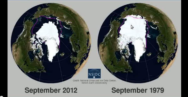
In October 2012, National Snow and Ice Data Center (NSIDC) released an animated map of 2012 Arctic and Antarctic sea ice extent shown side-by-side with 1979 – 2009 climatology.


For more information and visualizations of thinning sea ice, see the NOAA Climate Watch article, “Arctic Sea Ice Getting Thinner, Younger.”

Source: NSDIC

Share:

Commenting rules and guidelines

We value the thoughts and opinions of our readers and welcome healthy discussions on our website. In order to maintain a respectful and positive community, we ask that all commenters follow these rules:

  • Treat others with kindness and respect.
  • Stay on topic and contribute to the conversation in a meaningful way.
  • Do not use abusive or hateful language.
  • Do not spam or promote unrelated products or services.
  • Do not post any personal information or content that is illegal, obscene, or otherwise inappropriate.

We reserve the right to remove any comments that violate these rules. By commenting on our website, you agree to abide by these guidelines. Thank you for helping to create a positive and welcoming environment for all.

One Comment

  1. antarctica’s “continental climate” will keep it insulated from the effects of global warming to a certain extent. However, ice is a simple substance that behaves very simply. The hotter it gets, the more it melts. And one can’t argue against the fact that the ice in the Arctic has been melting quite a bit lately. Eventually, Antarctica will lose a great quantity of its ice too.

Leave a reply

Your email address will not be published. Required fields are marked *