Strong and shallow earthquake M 5.4 struck eastern Kashmir
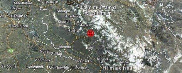
A strong and shallow earthquake M 5.4 struck eastern Kashmir region, India on Wednesday, May 01, 2013 at 06:57 UTC. Epicenter of the earthquake was located 17 km (10 miles) NE of Bhadarwah, India and 23 km (14 miles) SSE of Kishtwar, India at coordinates 33.100°N, 75.838°E. USGS reported depth of this shallow earthquake at 9.8 km, whereas EMSC reported depth at 40 km and magnitude 5.6.
Tremors of the earthquake were also felt in Pakistan and as far as UAE. Sources informed Earthquake-report that an elderly villager was killed in Kishtwar, when a bolder hit him while he was rushing out of his home. As per KashmirLife, 30 school children and one teacher in two different schools were injured seriously and hospitalized.
According to GDACS, this earthquake can have a low humanitarian impact based on the Magnitude and the affected population and their vulnerability. The same region reportedly had a devastating earthquake of magnitude 7.8 in 1905 when 19,000 people had died.
There are about 4,180,000 people living within 100 km radius of this earthquake. The earthquake was strongly felt in India and Pakistan.
The earthquake was followed by an aftershock of magnitude 4.6 at 09:19 UTC.
| 5.4 | |
| Date-Time |
|
| Location | 33.100°N, 75.838°E |
| Depth | 9.8 km (6.1 miles) |
| Region | EASTERN KASHMIR |
| Distances | 17 km (10 miles) NE of Bhadarwah, India 23 km (14 miles) SSE of Kishtwar, India 23 km (14 miles) E of Doda, India 67 km (41 miles) ENE of Udhampur, India |
| Location Uncertainty | horizontal +/- 14.8 km (9.2 miles); depth +/- 3.9 km (2.4 miles) |
| Parameters | NST= 99, Nph=108, Dmin=247.1 km, Rmss=1.4 sec, Gp= 25°, M-type=teleseismic moment magnitude (Mw), Version=A |
| Source |
|
| Event ID | usb000gjhz |

Kashmir earthquake intensity shakemap. Credits: USGS
Tectonic Summary by USGS
Seismotectonics of the Himalaya and Vicinity
Seismicity in the Himalaya dominantly results from the continental collision of the India and Eurasia plates, which are converging at a relative rate of 40-50 mm/yr. Northward underthrusting of India beneath Eurasia generates numerous earthquakes and consequently makes this area one of the most seismically hazardous regions on Earth. The surface expression of the plate boundary is marked by the foothills of the north-south trending Sulaiman Range in the west, the Indo-Burmese Arc in the east and the east-west trending Himalaya Front in the north of India.
The India-Eurasia plate boundary is a diffuse boundary, which in the region near the north of India, lies within the limits of the Indus-Tsangpo (also called the Yarlung-Zangbo) Suture to the north and the Main Frontal Thrust to the south. The Indus-Tsangpo Suture Zone is located roughly 200 km north of the Himalaya Front and is defined by an exposed ophiolite chain along its southern margin. The narrow (<200km) Himalaya Front includes numerous east-west trending, parallel structures. This region has the highest rates of seismicity and largest earthquakes in the Himalaya region, caused mainly by movement on thrust faults. Examples of significant earthquakes, in this densely populated region, caused by reverse slip movement include the 1934 M8.1 Bihar, the 1905 M7.5 Kangra and the 2005 M7.6 Kashmir earthquakes. The latter two resulted in the highest death tolls for Himalaya earthquakes seen to date, together killing over 100,000 people and leaving millions homeless. The largest instrumentally recorded Himalaya earthquake occurred on 15th August 1950 in Assam, eastern India. This M8.6 right-lateral, strike-slip, earthquake was widely felt over a broad area of central Asia, causing extensive damage to villages in the epicentral region.
The Tibetan Plateau is situated north of the Himalaya, stretching approximately 1000km north-south and 2500km east-west, and is geologically and tectonically complex with several sutures which are hundreds of kilometer-long and generally trend east-west. The Tibetan Plateau is cut by a number of large (>1000km) east-west trending, left-lateral, strike-slip faults, including the long Kunlun, Haiyuan, and the Altyn Tagh. Right-lateral, strike-slip faults (comparable in size to the left-lateral faults), in this region include the Karakorum, Red River, and Sagaing. Secondary north-south trending normal faults also cut the Tibetan Plateau. Thrust faults are found towards the north and south of the Tibetan Plateau. Collectively, these faults accommodate crustal shortening associated with the ongoing collision of the India and Eurasia plates, with thrust faults accommodating north south compression, and normal and strike-slip accommodating east-west extension.
Along the western margin of the Tibetan Plateau, in the vicinity of south-eastern Afghanistan and western Pakistan, the India plate translates obliquely relative to the Eurasia plate, resulting in a complex fold-and-thrust belt known as the Sulaiman Range. Faulting in this region includes strike-slip, reverse-slip and oblique-slip motion and often results in shallow, destructive earthquakes. The active, left-lateral, strike-slip Chaman fault is the fastest moving fault in the region. In 1505, a segment of the Chaman fault near Kabul, Afghanistan, ruptured causing widespread destruction. In the same region the more recent 30 May 1935, M7.6 Quetta earthquake, which occurred in the Sulaiman Range in Pakistan, killed between 30,000 and 60,000 people.
On the north-western side of the Tibetan Plateau, beneath the Pamir-Hindu Kush Mountains of northern Afghanistan, earthquakes occur at depths as great as 200 km as a result of remnant lithospheric subduction. The curved arc of deep earthquakes found in the Hindu Kush Pamir region indicates the presence of a lithospheric body at depth, thought to be remnants of a subducting slab. Cross-sections through the Hindu Kush region suggest a near vertical northerly-dipping subducting slab, whereas cross-sections through the nearby Pamir region to the east indicate a much shallower dipping, southerly subducting slab. Some models suggest the presence of two subduction zones; with the Indian plate being subducted beneath the Hindu Kush region and the Eurasian plate being subducted beneath the Pamir region. However, other models suggest that just one of the two plates is being subducted and that the slab has become contorted and overturned in places.
Shallow crustal earthquakes also occur in this region near the Main Pamir Thrust and other active Quaternary faults. The Main Pamir Thrust, north of the Pamir Mountains, is an active shortening structure. The northern portion of the Main Pamir Thrust produces many shallow earthquakes, whereas its western and eastern borders display a combination of thrust and strike-slip mechanisms. On the 18 February 1911, the M7.4 Sarez earthquake ruptured in the Central Pamir Mountains, killing numerous people and triggering a landside, which blocked the Murghab River.
Featured image: Google 2013. Image: TerraMetrics 2013.
Commenting rules and guidelines
We value the thoughts and opinions of our readers and welcome healthy discussions on our website. In order to maintain a respectful and positive community, we ask that all commenters follow these rules:
We reserve the right to remove any comments that violate these rules. By commenting on our website, you agree to abide by these guidelines. Thank you for helping to create a positive and welcoming environment for all.