New activity at Mt. Cleveland volcano on Aleutian Islands
Alaska Volcano Observatory (AVO) infrasound detected 2-3 possible explosion at Cleveland Volcano early on May 4, 2013. The infrasound signals suggest that this was a relatively short duration, low-level explosion. A small, low-altitude ash cloud along with high elevated summit surface temperatures at the summit were observed in satellite views later during the day. AVO received no other reports of activity.
AVO upgraded Volcano Alert Level from Advisory to Watch and Aviation Color Code from Yellow to Orange. Sudden explosions of blocks and ash are possible with little or no warning. Ash clouds, if produced, could exceed 20,000 feet above sea level. If a large ash-producing event occurs, nearby seismic, infrasound, or volcanic lightning networks should alert AVO staff quickly. However, for some events, a delay of several hours is possible. There is no real-time seismic monitoring network on Mount Cleveland and AVO is unable to track activity in real time.
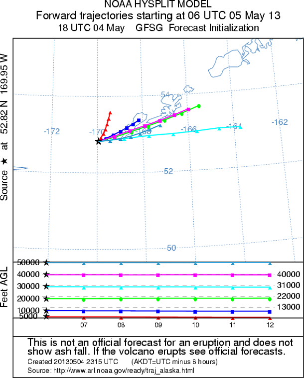
Cleveland Ash Trajectory Forecasts (Credit: AVO/NOAA/ARL)
Cleveland volcano forms the western half of Chuginadak Island, a remote and uninhabited island in the east central Aleutians. It is located about 75 km (45 mi.) west of the community of Nikolski, and 1500 km (940 mi.) southwest of Anchorage. The volcano’s most recent significant eruption began in February, 2001 and it produced 3 explosive events that produced ash clouds as high as 12 km (39,000 ft) above sea level. The 2001 eruption also produced a rubbly lava flow and hot avalanche that reached the sea. The most recent minor ash emissions were observed in November 2012.
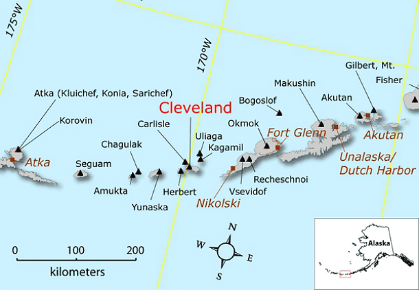
Location of Cleveland volcano and other Aleutian volcanoes with respect to nearby cities and towns. (Image courtesy of the AVO/ADGGS)
Location: N 52 deg 49 min W 169 deg 56 min
Elevation: 5676 ft (1730 m)
Area: Aleutians Alaska
Source: Alaska Volcano Observatory
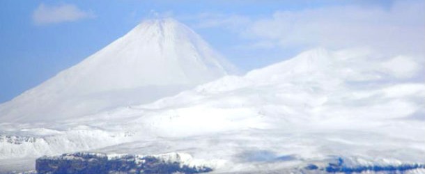
Featured image: Photo of Mt Cleveland taken on March 11, 2012 by Lt. Matthew Davis aboard the NOAA ship Oscar Dyson. Photo taken while transiting north through Samalga pass while on fisheries survey. (Credit: Matthew Davis/AVO, Image courtesy of NOAA)
Commenting rules and guidelines
We value the thoughts and opinions of our readers and welcome healthy discussions on our website. In order to maintain a respectful and positive community, we ask that all commenters follow these rules:
We reserve the right to remove any comments that violate these rules. By commenting on our website, you agree to abide by these guidelines. Thank you for helping to create a positive and welcoming environment for all.