Active volcanoes in the world: June 5 – June 11, 2013
This week, 9 volcanoes had new activity, whereas ongoing activity was also reported for 9 volcanoes. This report covers active volcanoes in the world recorded from June 5 – June 11, 2013 based on Smithsonian/USGS criteria.
New activity/unrest: | Negro, Cerro, Nicaragua | Chirinkotan, Kuril Islands | Copahue, Central Chile-Argentina border | Ibu, Halmahera | Kelimutu, Lesser Sunda Islands | Mayon, Luzon | Pavlof, Alaska Peninsula | San Cristóbal, Nicaragua | Veniaminof, Alaska Peninsula.
Ongoing activity: | Fuego, Guatemala | Karymsky, Eastern Kamchatka (Russia) | Kilauea, Hawaii (USA) | Kizimen, Eastern Kamchatka (Russia) | Papandayan, Java | Popocatépetl, México | Santa María, Guatemala | Shiveluch, Central Kamchatka (Russia) | Tolbachik, Central Kamchatka (Russia).
The Weekly Volcanic Activity Report is a cooperative project between the Smithsonian's Global Volcanism Program and the US Geological Survey's Volcano Hazards Program. Updated by 2300 UTC every Wednesday, notices of volcanic activity posted on these pages are preliminary and subject to change as events are studied in more detail. This is not a comprehensive list of all of Earth's volcanoes erupting during the week, but rather a summary of activity at volcanoes that meet criteria discussed in detail in the "Criteria and Disclaimers" section. Carefully reviewed, detailed reports on various volcanoes are published monthly in the Bulletin of the Global Volcanism Network.
New activity/unrest
NEGRO, Cerro (Nicaragua)
12.506°, 86.702°; summit elev. 728 m
INETER reported that the seismic station at the base of Cerro Negro recorded the onset of tremor at 0845 on 4 June. Seismicity fluctuated; Real-time Seismic Amplitude Measurement (RSAM) values increased to 60 units, from an average value of 14. From 1535 to 1731 the network recorded 49 earthquakes that were too small to be located.
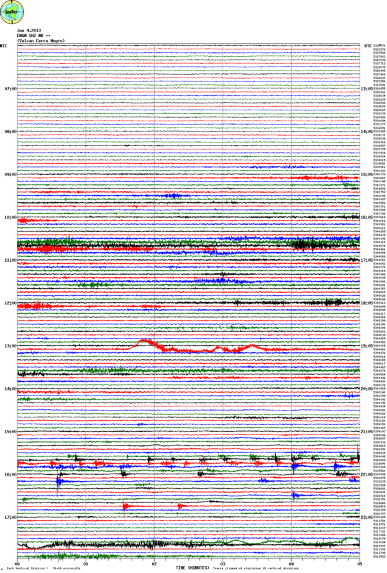
Seismic recording on 4 June (CNGN station, INETER)
Geologic summary: Central America's youngest volcano, Cerro Negro, was born in April 1850 and has since been one of the most active volcanoes in Nicaragua. Cerro Negro is the largest, southernmost, and most recent of a group of four youthful cinder cones constructed along a NNW-SSE-trending line in the central Marrabios Range 5 km NW of Las Pilas volcano. Strombolian-to-subplinian eruptions at Cerro Negro at intervals of a few years to several decades have constructed a roughly 250-m-high basaltic cone and an associated lava field that is constrained by topography to extend primarily to the NE and SW. Cone and crater morphology at Cerro Negro have varied significantly during its eruptive history. Although Cerro Negro lies in a relatively unpopulated area, its occasional heavy ashfalls have caused damage to crops and buildings in populated regions of the Nicaraguan depression.
CHIRINKOTAN, Russia
48.980°, 153.480°; summit elev. 724 m
SVERT reported that steam and gas activity at Chirinkotan was observed in satellite imagery on 5, 7, and 9 June.
Steam plume from Chirinkotan volcano in the Kuriles on 5 June, Terra false color image (Credit: MODIS, NASA)
Geologic summary: The small, mostly unvegetated 3-km-wide island of Chirinkotan occupies the far end of an E-W-trending volcanic chain that extends nearly 50 km west of the central part of the main Kuril Islands arc. Chirinkotan is the emergent summit of a volcano that rises 3000 m from the floor of the Kuril Basin. A small 1-km-wide caldera about 300-400 m deep is open to the SE. Lava flows from a cone within the breached crater reached the north shore of the island. Historical eruptions have been recorded at Chirinkotan since the 18th century. Fresh lava flows also descended the SE flank of Chirinkotan during an eruption in the 1880s that was observed by the English fur trader Captain Snow.
COPAHUE, Central Chile-Argentina border
37.85°S, 71.17°W; summit elev. 2997 m
OVDAS-SERNAGEOMIN reported that during 4-11 June white plumes recorded by a web camera rose at most 200 m above Copahue and drifted N and E. During 4-5 June seismicity had decreased with respect to the previous 24-hour period; the majority of the signals were low-magnitude hybrid events, detected at an average rate of 42 per hour. During 5-6 June seismicity was similar to the previous period, with an average of 50 events per hour being detected. Seismicity increased during 6-7 June; an average of 84 events per hour was detected. During 7-8 June seismicity fluctuated with a high average of 124 events per hour then decreased to a low average of 8 events per hour; the overall average was 62 events per hour. Seismicity decreased during 8-9 June; only 5 events per hour were detected. On 9 June OVDAS-SERNAGEOMIN scientists aboard an overflight to locate sites for the installation of three additional seismic stations observed fumaroles inside Del Agrio Crater, and gas emissions that rose at most 200 m and drifted NE. They noted that no lava dome was present. During 9-10 June the number of earthquakes increased to an average of 20 events per hour. The Alert Level remained at Orange.
Geologic summary: Volcán Copahue is an elongated composite cone constructed along the Chile-Argentina border within the 6.5 x 8.5 km wide Trapa-Trapa caldera that formed between 0.6 and 0.4 million years ago near the NW margin of the 20 x 15 km Pliocene Caviahue (Del Agrio) caldera. The eastern summit crater, part of a 2-km-long, ENE-WSW line of nine craters, contains a briny, acidic 300-m-wide crater lake (also referred to as El Agrio or Del Agrio) and displays intense fumarolic activity. Acidic hot springs occur below the eastern outlet of the crater lake, contributing to the acidity of the Río Agrio, and another geothermal zone is located within Caviahue caldera about 7 km NE of the summit. Infrequent mild-to-moderate explosive eruptions have been recorded at Copahue since the 18th century. Twentieth-century eruptions from the crater lake have ejected pyroclastic rocks and chilled liquid sulfur fragments.
IBU, Indonesia
1.488°, 127.630°; summit elev. 1325 m
CVGHM reported that during May through 6 June white-to-gray plumes rose 200-450 m above Ibu's crater rim. Seismicity increased and volcanic tremor was detected. The lava dome contained to grow, especially the N part, and in early June had grown taller than the N crater rim. Based on visual and instrumental observations, as well as the hazard potential, CVGHM increased the Alert Level to 3 (on a scale of 1-4) on 7 June. The public was warned to stay at least 3 km away from the active crater.
Geologic summary: The truncated summit of Gunung Ibu stratovolcano along the NW coast of Halmahera Island has large nested summit craters. The inner crater, 1 km wide and 400 m deep, contained several small crater lakes through much of historical time. The outer crater, 1.2 km wide, is breached on the north side, creating a steep-walled valley. A large parasitic cone is located ENE of the summit. A smaller one to the WSW has fed a lava flow down the western flank. A group of maars is located below the northern and western flanks of the volcano. Only a few eruptions have been recorded from Ibu in historical time, the first a small explosive eruption from the summit crater in 1911. An eruption producing a lava dome that eventually covered much of the floor of the inner summit crater began in December 1998.
KELIMUTU, Indonesia
-8.770°, 121.820°; summit elev. 1639 m
CVGHM reported that on 3 June the water in Kelimutu’s Crater II (Tiwu Nua Muri Kooh Tai Crater) turned from blue to a light brown color, “smoke” rose 50 m above the crater, “rustling water sounds” were heard near the wall of Crater I (Tiwu Ata Polo), and a sharp sulfur odor was noted. That evening a weak sulfur odor was reported in Pemo (3 km). Plants within 2 km S and SE appeared to have wilted.
Geologic summary: Kelimutu is a small, but well-known Indonesian volcano in central Flores Island with three summit crater lakes of varying colors. The western lake, Tiwi Ata Mbupu (Lake of Old People) is commonly blue. Tiwu Nua Muri Kooh Tai (Lake of Young Men and Maidens) and Tiwu Ata Polo (Bewitched, or Enchanted Lake), which share a common crater wall, are commonly green- and red-colored, respectively, although lake colors vary periodically. Active upwelling, probably fed by subaqueous fumaroles, occurs at the two eastern lakes. The scenic lakes are a popular tourist destination and have been the source of minor phreatic eruptions in historical time. The summit of the compound 1639-m-high Kelimutu volcano is elongated 2 km in a WNW-ESE direction; the older cones of Kelido and Kelibara are located respectively 3 km to the north and 2 km to the south.
MAYON, Luzon
13.257°N, 123.685°E; summit elev. 2462 m
PHIVOLCS reported that during 5-10 June white to off-white steam plumes that drifted WSW, NW, WNW, NNE, and NE, and occasional bluish fumes, were observed at Mayon. Incandescence emanated from the crater during most evenings into early mornings; cloud cover prevented crater observations during 7-8 and 10-11 June. During 5-6 and 9-10 June the seismic network recorded one volcanic earthquake each period, and during 6-7 June one rockfall signal was detected. The Alert Level remained at 1; PHIVOLCS reminded the public not to enter the 6-km-radius Permanent Danger Zone (PDZ).
Geologic summary: Beautifully symmetrical Mayon volcano, which rises to 2,462 m above the Albay Gulf, is the Philippines' most active volcano. The structurally simple volcano has steep upper slopes that average 35-40° and is capped by a small summit crater. The historical eruptions of this basaltic-andesitic volcano date back to 1616 and range from Strombolian to basaltic Plinian. Eruptions occur predominately from the central conduit and have also produced lava flows that travel far down the flanks. Pyroclastic flows and mudflows have commonly swept down many of the approximately 40 ravines that radiate from the summit and have often devastated populated lowland areas. Mayon's most violent eruption, in 1814, killed more than 1,200 people and devastated several towns. Eruptions that began in February 2000 led PHIVOLCS to recommend on 23 February 2000 the evacuation of people within a radius of 7 km from the summit in the SE and within a 6 km radius for the rest of the volcano.
PAVLOF, Alaska Peninsula
55.42°N, 161.887°W; summit elev. 2519 m
AVO reported that ash emissions from Pavlof that began on 4 June continued during 5-11 June, and were accompanied by seismic tremor and explosion signals. Overnight during 4-8 June satellite images detected elevated surface temperatures near the vent consistent with lava effusion and fountaining. On 5 and 6 June an ash plume observed in images drifted 40-45 km W and SW, at altitudes of 4.3-5.5 km (14,000-18,000 ft) a.s.l., based on pilot estimates. During 8-10 June images showed an ash plume drifting 20-53 km SE. The Volcanic Alert Level remained at Watch and the Aviation Color Code remained at Orange.
Aerial view of Pavlof volcano, June 7, 2013. (Photo courtesy of Theo Chesley/AVO)
Geologic summary: The most active volcano of the Aleutian arc, Pavlof is a 2519-m-high Holocene stratovolcano that was constructed along a line of vents extending NE from the Emmons Lake caldera. Pavlof and its twin volcano to the NE, 2142-m-high Pavlof Sister, form a dramatic pair of symmetrical, glacier-covered stratovolcanoes that tower above Pavlof and Volcano bays. A third cone, Little Pavolf, is a smaller volcano on the SW flank of Pavlof volcano, near the rim of Emmons Lake caldera. Unlike Pavlof Sister, Pavlof has been frequently active in historical time, typically producing strombolian to vulcanian explosive eruptions from the summit vents and occasional lava flows. The active vents lie near the summit on the north and east sides. The largest historical eruption of Pavlof took place in 1911, at the end of a 5-year-long eruptive episode; a fissure opened on the northern flank of the volcano, ejecting large blocks and issuing lava flows.
SAN CRISTOBAL, Nicaragua
12.702°, -87.004°; summit elev. 1745 m
INETER reported that on 7 June seven explosions at San Cristóbal ejected gas and ash, and were detected by the seismic station located on the W flank. The explosions occurred at 0615, 0645, 0653, 0911, 1137, 1139, and 1143, and were also observed by civil defense and INETER staff. The largest explosion, at 1139, generated a plume that rose 100 m. Sulfur dioxide emissions, which had been low, increased. A report later that afternoon stated that gas-and-ash explosions decreased, but Real-time Seismic-Amplitude Measurement (RSAM) values almost tripled to between 80 and 100 units due to increased tremor. INETER noted that tremor is frequently detected at San Cristóbal, and for the public not to be alarmed. A small lahar occurred at 1710.
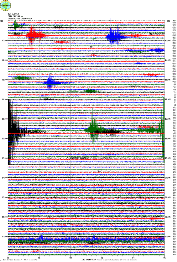
Seismic recording from San Cristobal volcano on June 7, 2013 (CRIN station, INETER)
Geologic summary: The San Cristóbal volcanic complex, consisting of five principal volcanic edifices, forms the NW end of the Marrabios Range. The symmetrical 1745-m-high youngest cone, named San Cristóbal (also known as El Viejo), is Nicaragua's highest volcano and is capped by a 500 x 600 m wide crater. El Chonco, with several flank lava domes, is located 4 km to the west of San Cristóbal; it and the eroded Moyotepe volcano, 4 km to the NE of San Cristóbal, are of Pleistocene age. Volcán Casita, containing an elongated summit crater, lies immediately east of San Cristóbal and was the site of a catastrophic landslide and lahar in 1998. The Plio-Pleistocene La Pelona caldera is located at the eastern end of the San Cristóbal complex. Historical eruptions from San Cristóbal, consisting of small-to-moderate explosive activity, have been reported since the 16th century. Some other 16th-century eruptions attributed to Casita volcano are uncertain and may pertain to other Marrabios Range volcanoes.
VENIAMINOF, United States
56.170°, -159.380°; summit elev. 2507 m
On 8 June AVO reported that gradually increasing seismic tremor at Veniaminof had been detected during the previous two days. The Aviation Color Code was raised to Yellow and the Volcano Alert Level was raised to Advisory. Clear web-camera and satellite views showed nothing unusual at the volcano. During 8-10 June seismicity continued to increase and a persistent steam plume rose from the central cone within the caldera.
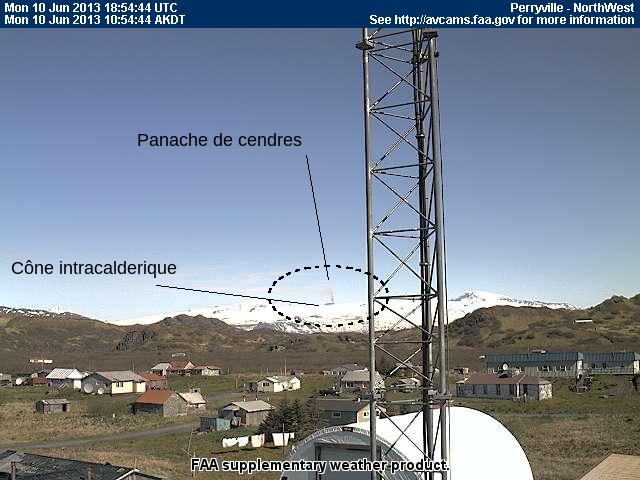
Small ash plume from Veniaminof volcano (FAA webcam, annotated by Blog Culture Volcan)
Geologic summary: Massive Veniaminof volcano, one of the highest and largest volcanoes on the Alaska Peninsula, is truncated by a steep-walled, 8 x 11 km, glacier-filled caldera that formed around 3700 years ago. The caldera rim is up to 520 m high on the north, is deeply notched on the west by Cone Glacier, and is covered by an ice sheet on the south. Post-caldera vents are located along a NW-SE zone bisecting the caldera that extends 55 km from near the Bering Sea coast, across the caldera, and down the Pacific flank. Historical eruptions probably all originated from the westernmost and most prominent of two intra-caldera cones, which reaches an elevation of 2156 m and rises about 300 m above the surrounding icefield. The other cone is larger, and has a summit crater or caldera that may reach 2.5 km in diameter, but is more subdued and barely rises above the glacier surface.
Ongoing activity
FUEGO, Guatemala
14.473°N, 90.880°W; summit elev. 3763 m
INSIVUMEH reported that during 5-8 June explosions at Fuego generated ash plumes that rose 200-500 m and drifted 4-6 km W and NW. The explosions produced weak rumbling, ejected incandescent material 100 m above the crater, and generated avalanches. On 8 June lahars descended the Las Lajas and El Jute drainages (SE), and the Ceniza drainage (SSW). During 9-11 June explosions produced ash plumes that rose 500-1,200 m and drifted 8-12 km W and NW. The explosions again produced rumbling, ejected incandescent material 150-300 m above the crater, and generated avalanches. Shock waves vibrated local structures during 8-9 June.
Geologic summary: Volcán Fuego, one of Central America's most active volcanoes, is one of three large stratovolcanoes overlooking Guatemala's former capital, Antigua. The scarp of an older edifice, Meseta, lies between 3,763-m-high Fuego and its twin volcano to the N, Acatenango. Construction of Meseta volcano continued until the late Pleistocene or early Holocene, after which growth of the modern Fuego volcano continued the southward migration of volcanism that began at Acatenango. Frequent vigorous historical eruptions have been recorded at Fuego since the onset of the Spanish era in 1524, and have produced major ashfalls, along with occasional pyroclastic flows and lava flows. The last major explosive eruption from Fuego took place in 1974, producing spectacular pyroclastic flows visible from Antigua.
KARYMSKY, Eastern Kamchatka (Russia)
54.05°N, 159.45°E; summit elev. 1536 m
KVERT reported that technical problems prevented seismic data collection at Karymsky during 31 May-7 June. Satellite data detected a thermal anomaly during 1-3 and 5 June. The Aviation Color Code remained at Orange.
Geologic summary: Karymsky, the most active volcano of Kamchatka's eastern volcanic zone, is a symmetrical stratovolcano constructed within a 5-km-wide caldera that formed about 7,600-7,700 radiocarbon years ago. Construction of the Karymsky stratovolcano began about 2,000 years later. The latest eruptive period began about 500 years ago, following a 2,300-year quiescence. Much of the cone is mantled by lava flows less than 200 years old. Historical eruptions have been Vulcanian or Vulcanian-Strombolian with moderate explosive activity and occasional lava flows from the summit crater. Most seismicity preceding Karymsky eruptions has originated beneath Akademia Nauk caldera, which is located immediately S of Karymsky volcano and erupted simultaneously with Karymsky in 1996.
KILAUEA, Hawaii (USA)
19.421°N, 155.287°W; summit elev. 1222 m
During 5-11 June HVO reported that the circulating lava lake occasionally rose and fell in the deep pit within Kilauea's Halema'uma'u Crater. The plume from the vent continued to deposit variable amounts of ash, spatter, and Pele's hair onto nearby areas. The lake level was 45-46 m below the Halema'uma'u crater floor during 5-6 June.
At Pu'u 'O'o Crater, glow emanated from three spatter cones and a small lava pond on the E part of the crater floor; the NE spatter cone produced a small lava flow on 5 June. The Kahauale’a II lava flows, fed by the NE spatter cone, were active as far N as 2 km and as far NNW as 1.6 km, and burned forest in both areas. Peace Day activity, fed by lava tubes extending from Pu'u 'O'o, consisted of some breakout activity on the pali and coastal plain, and ocean entries at locations inside and outside the National Park boundary.
Geologic summary: Kilauea, one of five coalescing volcanoes that comprise the island of Hawaii, is one of the world's most active volcanoes. Eruptions at Kilauea originate primarily from the summit caldera or along one of the lengthy E and SW rift zones that extend from the caldera to the sea. About 90% of the surface of Kilauea is formed of lava flows less than about 1,100 years old; 70% of the volcano's surface is younger than 600 years. A long-term eruption from the East rift zone that began in 1983 has produced lava flows covering more than 100 sq km, destroying nearly 200 houses and adding new coastline to the island.
KIZIMEN, Eastern Kamchatka (Russia)
55.130°N, 160.32°E; summit elev. 2376 m
KVERT reported that during 31 May-7 June moderate seismic activity continued at Kizimen. Video and satellite data showed that lava continued to extrude from the summit, producing incandescence, strong gas-and-steam activity, and hot avalanches on the W and E flanks. A thermal anomaly was detected daily in satellite images. The Aviation Color Code remained at Orange.
Geologic summary: Kizimen is an isolated, conical stratovolcano that is morphologically similar to Mount St. Helens prior to its 1980 eruption. The summit of Kizimen consists of overlapping lava domes, and blocky lava flows descend the flanks of the volcano, which is the westernmost of a volcanic chain north of Kronotsky volcano. The 2,376-m-high Kizimen was formed during four eruptive cycles beginning about 12,000 years ago and lasting 2,000-3,500 years. The largest eruptions took place about 10,000 and 8300-8400 years ago, and three periods of longterm lava-dome growth have occurred. The latest eruptive cycle began about 3,000 years ago with a large explosion and was followed by lava-dome growth lasting intermittently about 1,000 years. An explosive eruption about 1,100 years ago produced a lateral blast and created a 1.0 x 0.7 km wide crater breached to the NE, inside which a small lava dome (the fourth at Kizimen) has grown. A single explosive eruption, during 1927-28, has been recorded in historical time.
PAPANDAYAN, Indonesia
-7.320°, 107.730°; summit elev. 2665 m
CVGHM reported that observers at the Papandayan observation post in Pakuwon Village reported no significant changes at Papandayan during May and the beginning of June. They noted that during May plumes rose less than 100 m above Baru and Emas craters, and during 1-5 June plumes rose 20 m at most.
The energy of volcanic earthquakes sharply increased during 2-4 May, and then decreased on 5 May. The average number of volcanic earthquakes declined from 35-49 events per day in early-to-mid May, to 14 events per day in mid-to-late May. The number of events continued to decline through the beginning of June. The number of local tectonic earthquakes also decreased significantly from an average of 67-71 events per day in early-to-mid May, to 2-17 events per day the latter half of May, to about 2 events per day in early June.
Based on the visual observations and decline in seismicity, CVGHM lowered the Alert Level to 2 (on a scale of 1-4).
Geologic summary: Papandayan is a complex stratovolcano with four large summit craters, the youngest of which was breached to the NE by collapse during a brief eruption in 1772 and contains active fumarole fields. The broad 1.1-km-wide, flat-floored Alun-Alun crater truncates the summit of Papandayan, and Gunung Puntang to the north gives the volcano a twin-peaked appearance. Several episodes of collapse have given the volcano an irregular profile and produced debris avalanches that have impacted lowland areas beyond the volcano. A sulfur-encrusted fumarole field occupies historically active Kawah Mas ("Golden Crater"). After its first historical eruption in 1772, in which collapse of the NE flank produced a catastrophic debris avalanche that destroyed 40 villages and killed nearly 3000 persons, only small phreatic eruptions had occurred prior to an explosive eruption that began in November 2002.
POPOCATEPETL, México
19.023°N, 98.622°W; summit elev. 5426 m
CENAPRED reported that during 5-11 June seismicity at Popocatépetl indicated continuing gas-and-steam emissions that sometimes contained small amounts of ash; cloud cover often prevented visual confirmation. Incandescence from the crater was observed some nights; during 8-9 June incandescence increased with accompanying emissions. On most days steam-and-gas plumes were observed drifting SW and SSW. On 7 June the Alert Level was lowered to Yellow, Phase Two. An explosion on 8 June generated an ash plume that rose 1 km above the crater and drifted SW. On 9 June ash plumes rose 0.6-2.5 km and drifted SE and E.
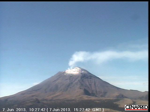
Webcam view of Popocatépetl volcano on June 7, 2013 (Credit: CENAPRED)
Geologic summary: Popocatépetl, whose name is the Aztec word for smoking mountain, towers to 5,426 m 70 km SE of Mexico City and is North America's second-highest volcano. Frequent historical eruptions have been recorded since the beginning of the Spanish colonial era. A small eruption on 21 December 1994 ended five decades of quiescence. Since 1996 small lava domes have incrementally been constructed within the summit crater and destroyed by explosive eruptions. Intermittent small-to-moderate gas-and-ash eruptions have continued, occasionally producing ashfall in neighboring towns and villages.
SANTA MARIA, Guatemala
14.756°N, 91.552°W; summit elev. 3772 m
In a special bulletin on 5 June, INSIVUMEH stated that residents of Quetzaltenango, 18 km WNW of Santa María, reported slight ashfall and a sulfur odor. On 6 June white and blue emissions rose 400 m from the E edge of the Santiaguito lava-dome complex’s active dome. The next day gas plumes rose 500 m and drifted N. On 8 June lahars carrying blocks descended the Nima I and Tambor drainages on the S flank. An explosion on 9 June generated an ash plume that rose 600 m and caused ashfall in Monte Claro (S). On 11 June white gas plumes rose 100 m and drifted SW. A few weak avalanches traveled S.
Geologic summary: Symmetrical, forest-covered Santa María volcano is one of a chain of large stratovolcanoes that rises dramatically above the Pacific coastal plain of Guatemala. The stratovolcano has a sharp-topped, conical profile that is cut on the SW flank by a large, 1-km-wide crater, which formed during a catastrophic eruption in 1902 and extends from just below the summit to the lower flank. The renowned Plinian eruption of 1902 followed a long repose period and devastated much of SW Guatemala. The large dacitic Santiaguito lava-dome complex has been growing at the base of the 1902 crater since 1922. Compound dome growth at Santiaguito has occurred episodically from four westward-younging vents, accompanied by almost continuous minor explosions and periodic lava extrusion, larger explosions, pyroclastic flows, and lahars.
SHIVELUCH, Central Kamchatka (Russia)
56.653°N, 161.360°E; summit elev. 3283 m
Based on visual observations and analyses of satellite data, KVERT reported that during 31 May-7 June a viscous lava flow effused on the N flank of Shiveluch's lava dome, accompanied by hot avalanches, incandescence, and fumarolic activity. Satellite imagery showed a daily thermal anomaly on the lava dome. On 10 June the seismic network detected an explosive event at 0902 that lasted 6.5 minutes, and indicated that an ash plume possibly rose to altitudes of 7-8 km (23,000-26,200 ft) a.s.l. The Aviation Color Code remained at Orange.
Geologic summary: The high, isolated massif of Shiveluch volcano (also spelled Sheveluch) rises above the lowlands NNE of the Kliuchevskaya volcano group and forms one of Kamchatka's largest and most active volcanoes. The currently active Molodoy Shiveluch lava-dome complex was constructed during the Holocene within a large breached caldera formed by collapse of the massive late-Pleistocene Strary Shiveluch volcano. At least 60 large eruptions of Shiveluch have occurred during the Holocene, making it the most vigorous andesitic volcano of the Kuril-Kamchatka arc. Frequent collapses of lava-dome complexes, most recently in 1964, have produced large debris avalanches whose deposits cover much of the floor of the breached caldera. Intermittent explosive eruptions began in the 1990s from a new lava dome that began growing in 1980. The largest historical eruptions from Shiveluch occurred in 1854 and 1964.
TOLBACHIK, Central Kamchatka (Russia)
55.830°N, 160.330°E; summit elev. 3682 m
KVERT reported that the S fissure along the W side of Tolbachinsky Dol, a lava plateau on the SW side of Tolbachik, continued to produce very fluid lava flows during 31 May-7 June that traveled to the W, S, and E sides of the plateau. Cinder cones continued to grow along the S fissure and weak gas-and-steam plumes were observed. A large thermal anomaly on the N part of Tolbachinsky Dol was visible daily in satellite imagery. The Aviation Color Code remained at Orange.
Geologic summary: The massive Tolbachik basaltic volcano is located at the southern end of the dominantly andesitic Kliuchevskaya volcano group. The Tolbachik massif is composed of two overlapping, but morphologically dissimilar volcanoes. The flat-topped Plosky Tolbachik shield volcano with its nested Holocene Hawaiian-type calderas up to 3 km in diameter is located east of the older and higher sharp-topped Ostry Tolbachik stratovolcano. The summit caldera at Plosky Tolbachik was formed in association with major lava effusion about 6500 years ago and simultaneously with a major southward-directed sector collapse of Ostry Tolbachik volcano. Lengthy rift zones extending NE and SSW of the volcano have erupted voluminous basaltic lava flows during the Holocene, with activity during the past two thousand years being confined to the narrow axial zone of the rifts. The 1975-76 eruption originating from the SSW-flank fissure system and the summit was the largest historical basaltic eruption in Kamchatka.
Source: Global Volcanism Program
Commenting rules and guidelines
We value the thoughts and opinions of our readers and welcome healthy discussions on our website. In order to maintain a respectful and positive community, we ask that all commenters follow these rules:
We reserve the right to remove any comments that violate these rules. By commenting on our website, you agree to abide by these guidelines. Thank you for helping to create a positive and welcoming environment for all.