Dalila strengthened to hurricane, moving away from southern Mexico coast
Tropical Storm Dalila strengthened to hurricane status on July 2, 2013. Dalila became the third hurricane of the 2013 Eastern Pacific Hurricane Season. The system should begin weakening in a day or so as it interacts with drier air and the developing cyclonic circulation to its east.
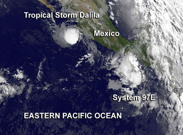
NOAA’s GOES-15 satellite captured an infrared image of Dalila as it was pulling away from the coast on July 2 at 12:00 UTC. In the meantime, System 97E started to form more southeast from Dalila. ( Credit: NASA GOES Project)
According to latest public advisory issued by US National Hurricane Center (NHC) at 21:00 UTC on July 2, 2013, the center of Hurricane Dalila was located about 195 miles (315 km) WSW of Manzanillo, Mexico at coordinates 18.4N 107.2W. The system is slowly drifting westward at speed of 2 mph (4 km/h). A slow motion toward the west or west-southwest is expected during the next 48 hours.
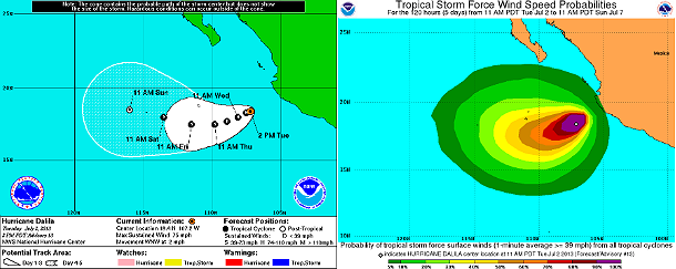
Dalila's forecast rack and tropical storm force wind speed probabilities maps (Credit: NOAA/National Hurricane Center)
Hurricane force winds extend outward up to 25 miles (35 km) from the center and tropical storm force winds extend outward up to 80 miles (130 km) from the center. Maximum sustained winds are near 75 mph (120 km/h) with higher gusts. The estimated minimum central pressure is 987 mb (29.15 inches). A couple of microwave passes indicated a low-level eye and a faint eye is seen in high-resolution visible satellite images.
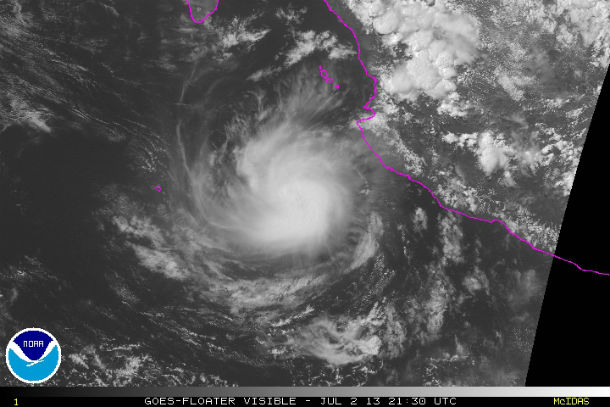
GOES-15 floater visible satellite image taken on July 2, 2013 at 21:30 UTC (Credit: NOAA/GOES)
The Navgem, GFDL and GFDN models forecast the storm to move northwestward west of Baja California, while ECMWF and UKMET forecast a southwestward motion due to interaction with the approaching disturbance. The GFS and the HWRF forecast a slow westward to west-southwestward motion. The new forecast track is south of and slower than the previous track based on the current location and motion.
The slower and more southerly track would keep the cyclone over warmer sea surface temperatures than previously forecast. ECMWF, UKMET and Canadian models all forecast Dalila to dissipate before 120 hours due to interaction with the disturbance. The intensity forecast compromises between these possibilities, showing little change in strength for 36-48 hours followed by a gradual weakening as the new disturbance gets closer.
.png)
Hurricane Dalila forecast track models (Credit: Spaghetti/UWM)
Swells generated by Dalila are affecting portions of the southwest coast of Mexico from near Zihuatanejo to Cabo Corrientes. These swells could cause life-threatening surf and rip current conditions.
Satellite Animations
- Storm-Centered Infrared (GOES 15; NOAA/SSD)
- Storm-Centered Infrared (Aviation Color Enhancement) (GOES 15; NOAA/SSD)
- Storm-Centered Water Vapor (GOES 15; NOAA/SSD)
- Storm-Centered Visible (GOES 15; NOAA/SSD)
- Storm-Centered Visible (Colorized) (GOES 15; NOAA/SSD)
- Tropical East Pacific Hurricane Sector Infrared (GOES 15; NOAA)
- Tropical East Pacific Hurricane Sector Water Vapor (GOES 15; NOAA)
- Tropical East Pacific Hurricane Sector Visible (GOES 15; NOAA)
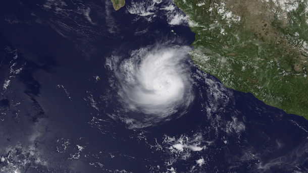
Featured image: GOES West satellite image taken on July 2, 2013 at 18:00 UTC (Credit: NOAA/GOES-15)
Commenting rules and guidelines
We value the thoughts and opinions of our readers and welcome healthy discussions on our website. In order to maintain a respectful and positive community, we ask that all commenters follow these rules.