Largest flood recorded beneath Antarctica mapped by CryoSat
ESA’s CryoSat satellite has found a vast crater in Antarctica’s icy surface for which scientists believe was left behind when a lake lying under about 3 km of ice suddenly drained.
The study, published recently in Geophysical Research Letters, highlights CryoSat’s unique capacity to map changes in Antarctica’s subglacial lakes in 3D, and sheds new light on events at the base of the ice sheet.
“Thanks to CryoSat, we can now see fine details that were not apparent in older satellite data records,” said Dr Malcolm McMillan from the UK’s University of Leeds and lead author of the study ‘Three-dimensional mapping by CryoSat-2 of subglacial lake volume changes’.
Far below the thick ice sheet that covers Antarctica, there are lakes of fresh water without a direct connection to the ocean. These lakes are of great interest to scientists who are trying to understand water transport and ice dynamics beneath the frozen Antarctic surface.
One method to obtain this information is to drill holes through kilometres of ice to the water. A completely new approach was applied by a team of European scientists. Instead of drilling holes they set their eyes looking through a satellite.
By combining new measurements acquired by CryoSat with older data from NASA’s ICESat satellite, the team has mapped the large crater left behind by a lake, and even determined the scale of the flood that formed it.
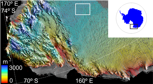
Location of the crater in Victoria Land, East Antarctica at about 73ºS and 156ºE. The colour scale shows height derived from CryoSat data. The crater is located within the white box. Copyright ESA/M. McMillan
From 2007 to 2008, six cubic kilometres of water was drained from the lake, making it the largest event of its kind ever recorded.That amount of water equals a tenth of the melting that occurs beneath Antarctica each year.
Since the end of 2008, the lake appears to be refilling but six times slower than it drained and it seems it could take decades to reform.

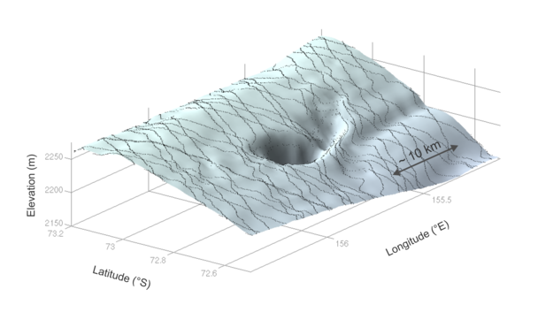
3D view of the crater created using CryoSat data. The satellite can measure both area and depth, allowing scientists to calculate the total volume of the crater: six cubic km. Copyright ESA/M. McMillan
The radar can measure both the area and depth of ice craters in high resolution, allowing scientists to calculate its volume accurately.
With every subglacial lake, there is hope of finding prehistoric marine life. The rapid draining and apparent refilling of this lake, however, suggests this was not the first time water has drained from the lake.
“It seems likely that the flood water – and any microbes or sediments it contained – has been flushed into the Southern Ocean, making it difficult to imagine that life in this particular lake has evolved in isolation,” said Prof. Andrew Shepherd, a co-author of the study.
About 400 lakes have been discovered at the base of the Antarctic ice sheet. When they drain, they disrupt subglacial habitats and can cause the ice above to slide more quickly into the sea.
CryoSat is ESA's Earth Explorer and a part of a series of Earth observation missions that focus on the science and research elements of ESA’s Living Planet Programme. Developed in direct response to issues identified by the scientific community, Earth observation missions aim to improve our understanding of how the Earth system works and how human activity is affecting natural Earth processes.
Since ice plays a crucial role in moderating Earth's climate and the effects of a changing climate are fast becoming apparent, particularly in the polar regions, it is important to understand exactly how Earth’s ice fields are responding.
For some years now, satellites such as ESA’s Envisat have been mapping the extent of ice cover and have shown that annual average Arctic sea-ice extent has shrunk by 2.7% per decade since 1978.
While these observations on ice extent provide invaluable data, this is only part of the picture. In order to understand fully how climate change is affecting these remote but sensitive regions, there remains an urgent need to determine exactly how the thickness of land and sea ice is changing. CryoSat is Europe's first mission to address this. It is in a highly inclined polar orbit, reaching latitudes of 88° north and south, to maximise its coverage of the poles.
CryoSat carries sophisticated technologies to measure changes at the margins of the vast ice sheets that overlay Greenland and Antarctica and marine ice floating in the polar oceans. Its main payload is an instrument called Synthetic Aperture Interferometric Radar Altimeter (SIRAL). SIRAL is first sensor of its kind optimized for ice. It can ‘see’ through clouds and in the dark, providing continuous measurements over areas like Antarctica, prone to bad weather and long periods of darkness.
By accurately measuring thickness change in both types of ice, it is providing information to complete the picture and leads to a better understanding of the role ice plays in the Earth system.
- Learn more on ESA's Earth Explorers here.
Source: ESA
Featured image: 3D view of the crater created using CryoSat data. The satellite can measure both area and depth, allowing scientists to calculate the total volume of the crater: six cubic km. Copyright ESA/M. McMillan
call me crazy, but i think that this big amount of fresh water, a real treasure, was stolen. when you understand by who, you will have the BIG PICTURE of what is happening in our world today.