Typhoon Soulik made landfall in northern Taiwan, now moves toward mainland China
Typhoon Soulik made its first landfall in northern Taiwan with wind gusts reported to 113 knots (210 km/h). Heavy rainfall and strong winds continue to affect central and northern Taiwan. There was one reported death related with Typhoon Soulik's landfall in Taiwan.
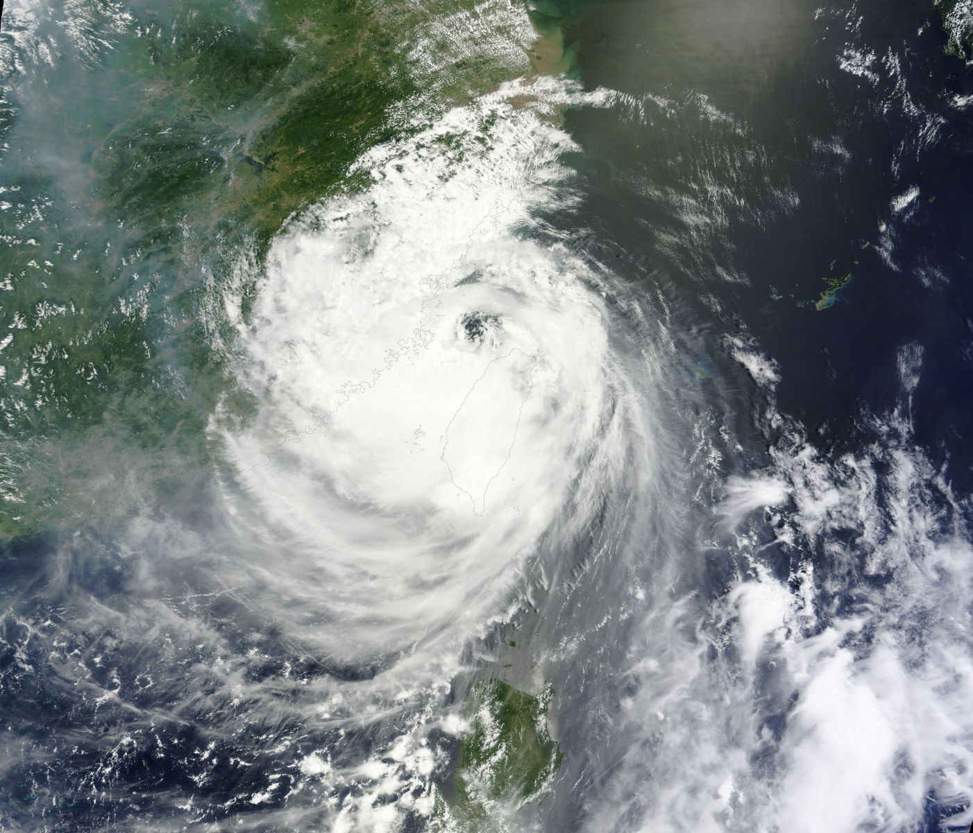
Terra MODIS satellite image taken at 02:35 UTC on July 13, 2013 (Credit: LANCE Rapid Response/MODIS)
As the system continues to track west towards Fuzhou, China heavy rainfall will continue to batter much of central and northern Taiwan, causing flash flooding and mudslides.Taiwan’s Central Weather Bureau reports maximum accumulated rainfall amount of 743 mm at Wufeng Township, Hsinchu County. The bureau estimated that the aggregate rainfall in the mountainous areas in Hsinchu, Miaoli, Nantou and Chiayi counties could top 1,000 mm.
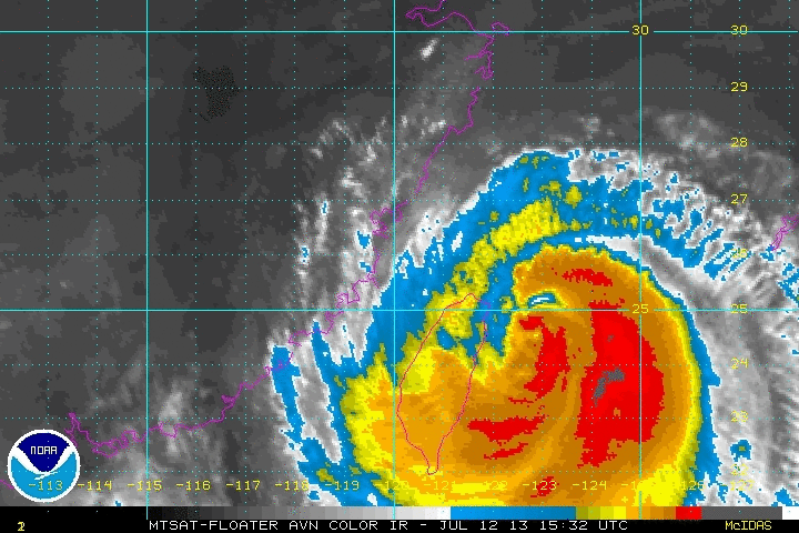
MTSAT AVN Infrared animated image shows the center of Typhoon Soulik crosses the Taiwan on July 13, 2013 (Credit: NOAA/MTSAT)
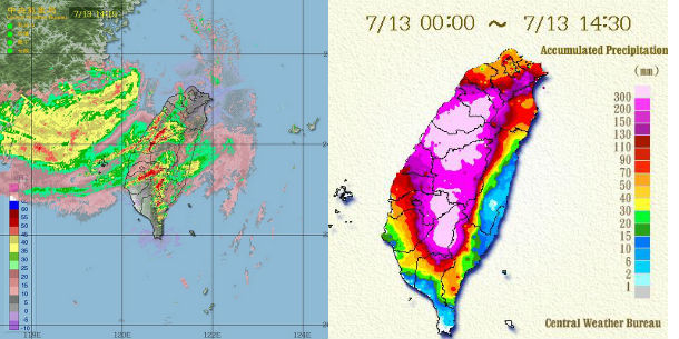
CWB's radar image and daily accumulated precipitation map shows heavy rainfall over central Taiwan on July 13, 2013 (Credit: Central Weather Bureau)

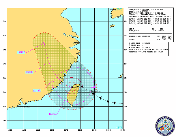
According to latest report by Joint Typhoon Warning Center (JTWC), the center of Typhoon Soulik was located 45 nm west- southwestward of Taipei, Taiwan. The system is moving westward at speed of 14 knots. Current maximum sustained winds are 75 knots (138 km/h) with gusts up to 90 knots (166 km/h).
.jpg)
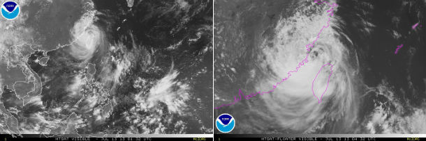
MTSAT-2 visible satellite imagery show Typhoon Soulik in Taiwan Strait after made its first landfall on July 13, 2013 at 01:32 UTC and closer look at 04:32 UTC (Credit: NOAA/MTSAT)
Typhoon Soulik is forecast to quickly track northwestward across the Taiwan Strait. The system will make landfall over eastern China in the next 12 hours with maximum sustained winds of approximately 65 knots (120 km/h). Soulik is not expected to strengthen significantly in the Taiwan Strait, because of the relatively cooler sea surface temperature (about 2 degrees cooler in the Strait) and the increased forward speed of the storm which is not conducive to storm intensification.
JTWC | PAGASA | JMA | TSR | CWB
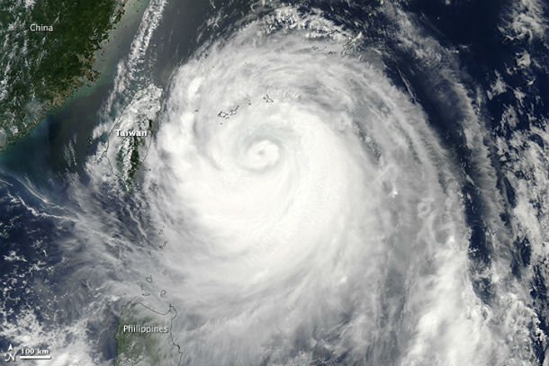
The Moderate Resolution Imaging Spectroradiometer (MODIS) on NASA’s Aqua satellite acquired this image Typhoon Soulik late on July 12, 2013 as approaching Taiwan. (NASA image courtesy Jeff Schmaltz, LANCE/EOSDIS MODIS Rapid Response Team at NASA GSFC. Caption by Holli Riebeek)
Satellite Animations
- Storm-Centered Infrared (MTSAT; NOAA/SSD)
- Storm-Centered Infrared (Aviation Color Enhancement) (MTSAT; NOAA/SSD)
- Storm-Centered Water Vapor (MTSAT; NOAA/SSD)
- Storm-Centered Visible (MTSAT; NOAA/SSD)
- Storm-Centered Visible (Colorized) (MTSAT; NOAA/SSD)
- West Pacific Infrared (MTSAT2; NOAA/SSD)
- West Pacific Infrared (Aviation Color Enhancement) (MTSAT2; NOAA/SSD)
- West Pacific Water Vapor (MTSAT2; NOAA/SSD)
- West Pacific Visible (MTSAT2; NOAA/SSD)
- West Pacific Visible (Colorized) (MTSAT2; NOAA/SSD)
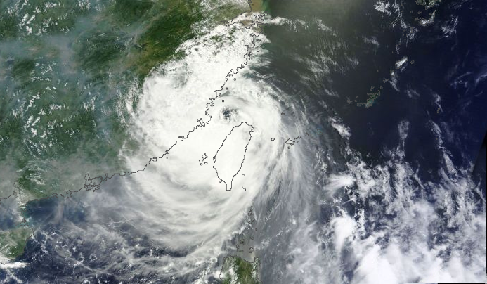
Featured image: MODIS satellite image of Typhoon Soulik on July 13, 2013 (Credit: LANCE Rapid Response/MODIS/Worldview)
Commenting rules and guidelines
We value the thoughts and opinions of our readers and welcome healthy discussions on our website. In order to maintain a respectful and positive community, we ask that all commenters follow these rules:
We reserve the right to remove any comments that violate these rules. By commenting on our website, you agree to abide by these guidelines. Thank you for helping to create a positive and welcoming environment for all.