Typhoon Usagi strengthens to Super-Typhoon – approaching Philippines, Taiwan and China

Typhoon Usagi, which formed on September 16, has strengthened into Super-Typhoon today. Warnings are up in the Philippines as it heads toward Taiwan and China. It was expected this storm would develop into one of the most violent storms of the season.
At 14:00 UTC on September 19, Super-Typhoon Usagi had maximum sustained winds near 140 knots/161.1 mph/259 km/h. It was located near 8.5N and 126.9E, about 422 nautical miles east-northeast of Manila and moving northwest at 9 knots/11 mph/16.6 km/h. Maximum significant wave height at 12:00 UTC today was 11.2 meters (37 feet).
Philippine officials have issued storm warnings, including flash flooding, landslides and storm surges, until Sunday, while Taiwan was expected to issue a sea alert late Thursday and a land alert on Friday, September 20. At 11:00 UTC today the National Meteorological Center of China (NMC) issued a yellow alert for the typhoon, the third highest on the country's four-tier weather warning system — with red being the most severe, followed by orange, yellow and blue.
Affected by the Super-Typhoon, strong wind will sweep waters in the east and north of Taiwan, the sea near China's Diaoyu Islands, the south of East China Sea and the northeast of South China sea, the NMC said.
Philippines warnings:
Public storm warning signal #1 is now in effect in the Luzon provinces of Ilocos Norte & Sur, Mt Province, Ifugao, Abra, Kalinga and Isabela.
Public storm warning signal #2 is in effect in the Luzon provinces of Batanes Group of Islands, Cagayan, Calayan, Babuyan Group of Islands and Apayao.
Usagi, which PAGASA named Odette, is expected to make landfall in China, on the coasts near Guangdong Province, as category 2 typhoon on the night of September 22/23. The landfall forecast will change according to latest observations.
Up to 30.8 million people people can be affected by Category 1 (120 km/h) or above wind speeds. In addition, 2.7 million people people are living in coastal areas below 5 m and can therefore be affected by storm surge.
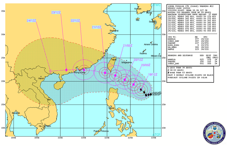
Super-Typhoon Usagi warning graphic. Credit: JTWC
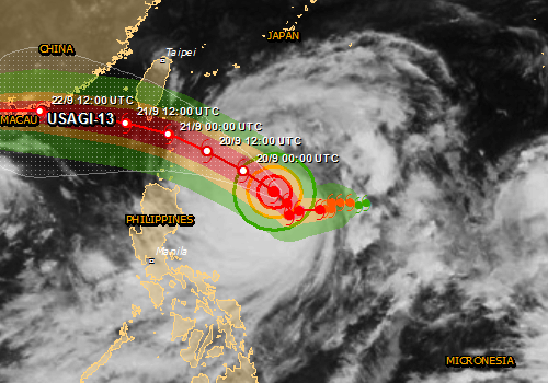
Super-Typhoon Usagi – cloud map. The map shows the areas affected by tropical storm strength winds (green), 58mph winds (orange) and cyclone wind strengths (red). (Source: JRC)

Image credit: NASA/Aqua
This infrared image from the AIRS instrument aboard NASA's Aqua satellite was taken today, September 19 at 05:17 UTC, before Usagi became a Super-Typhoon -but it shows the powerful thunderstorms with heavy rain potential (in purple) over a very large area.
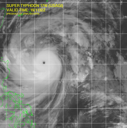
IR satellite image of Super-Typhoon Usagi on September 19, 2013 at 11:32 UTC
Featured image: Super-Typhoon Usagi – cloud map. The map shows the areas affected by tropical storm strength winds (green), 58mph winds (orange) and cyclone wind strengths (red). (Source: JRC)
Commenting rules and guidelines
We value the thoughts and opinions of our readers and welcome healthy discussions on our website. In order to maintain a respectful and positive community, we ask that all commenters follow these rules:
We reserve the right to remove any comments that violate these rules. By commenting on our website, you agree to abide by these guidelines. Thank you for helping to create a positive and welcoming environment for all.