Intense earthquake swarm offshore North Iceland – 1 000 quakes in 6 days
An intense earthquake swarm has been going on offshore North Iceland, 10 km NW of Gjögurtá, since September 25, 2013. This morning, 2 earthquakes reaching magnitude 3 and 3.2 occurred at 06:14 and 07:41 UTC. Roughly 1 000 earthquakes have been recorded by Icelandic Meteorological Office in last 6 days (IMO).
The depths of the quakes vary from about 15 km depth (crust-mantle boundary) to near surface. The area is located on an active fault line related to rifting, and a possible cause of the earthquake swarm could be a magmatic intrusion at Tjörnes Fracture Zone volcano (VD).
University of Iceland © Icelandic Meteorological Office
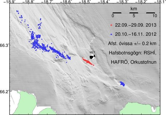
Image above: Map of relative locations, September 25 to October 1, 2013 offshore North Iceland. Roughly 1000 earthquakes have been recorded in the swarm. Topography of seabed: Bryndís Brandsdóttir, Institute of Earth Sciences, University of Iceland.
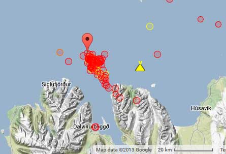
Location of recent quakes with relation to Tjörnes Fracture Zone volcano. Image credit: Google Earth/Volcano Discovery
.png)
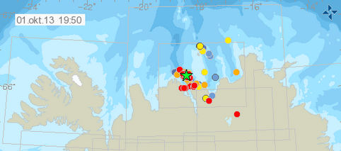
Iceland earthquake swarm map – October 1, 2013. Image credit: IMO
The offshore Tjörnes Fracture Zone is an oblique transform zone that separates the northern volcanic zone of Iceland from the Kolbeinsey Ridge, part of the Mid-Atlantic Ridge north of Iceland. A submarine eruption was reported during 1867-1868 at the SE part of the fissure system off the northern coast of Iceland along the Manareyjar Ridge immediately north of Manareyjar Island (GVP).
Featured image: Iceland earthquake swarm map – October 1, 2013. Image credit: IMO
Commenting rules and guidelines
We value the thoughts and opinions of our readers and welcome healthy discussions on our website. In order to maintain a respectful and positive community, we ask that all commenters follow these rules.