Magnitude 6.2 earthquake struck off the coast of New Zealand's South Island
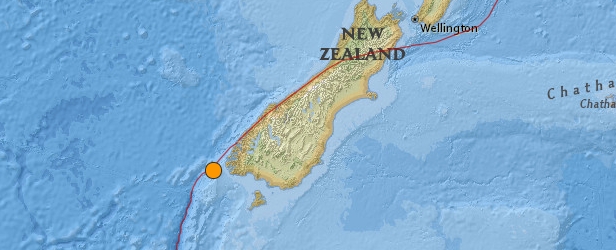
New Zealand's GEONET recorded strong earthquake measuring M 6.2 on December 17 at 01:07 local time (December 16 at 12:07 UTC). Epicenter was located 125 km west of Tuatapere at shallow depth of 25 km.
USGS measured this quake as M 5.6 at depth of 11 km.
GEONET reported that as of 9:30 am (local time on December 17) they have received 234 felt reports from the public, most reporting little damage. This lack of damage is due to the earthquake occurring far enough away from the main populated areas of the region. There have already been several aftershocks from this quake, though most have been too small for people to feel.
Earthquakes in the Fiordland region are due to the collision of the Australian and Pacific plates. The mainshock early this morning was a large reverse faulting or thrust mechanism resulting from the Australian plate pushing (subducting) beneath the Pacific plate. Fiordland sits upon on the Pacific plate.
It is unlikely that this earthquake will have an effect on the Alpine Fault hundreds of kilometres further to the north.
Fiordland is one of New Zealand's more seismically active regions – due to the plate subduction – but it is also our most sparsely populated region, there have been a dozen large earthquakes (M6+) in the region in the previous twenty years, many that were much larger than the Canterbury earthquakes, but none have caused nearly as much damage due to the sparse population and people's distance from the quakes epicentres. These Fiordland quakes often also release their energy slightly slower, so that the shaking is less violent than an earthquake of equivalent magnitude elsewhere in the country. The motion is more "rolling" rather than "snapping" which will contribute to the lack of damage.
The largest quake Fiordland has experienced in recent times was the M7.8 Dusky Sound earthquake on 15th July 2009. That quake was New Zealand's largest since the 1931 Hawke's Bay earthquake, it occurred close to the coast and produced a small local tsunami. The quake early this morning was 70 km southwest of the Dusky Sound earthquake.
Other notable Fiordland quakes in the last decade are the M6.7 George Sound quake in 2007 and the M7.2 Fiordland quake in 2003.
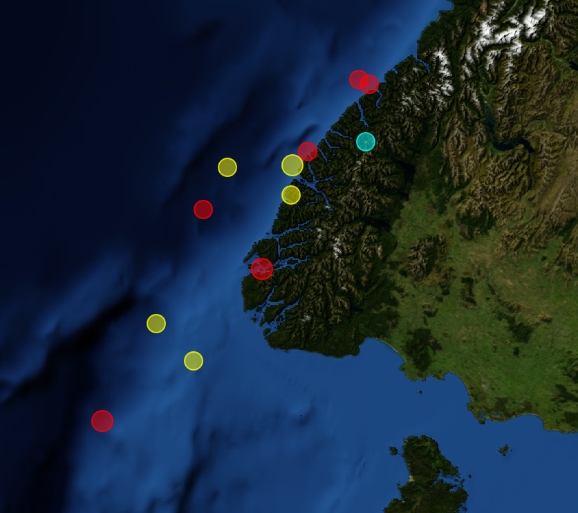
All M6+ quakes in the Fiordland region in the previous 20 years. The size of the circles represent magnitude, the colour represents their depth. Red – less than 15 km; Yellow – 15-40 km; Aqua – 100-200 km. Today's quake is the southern-most yellow circle. Image credit: GNS Science
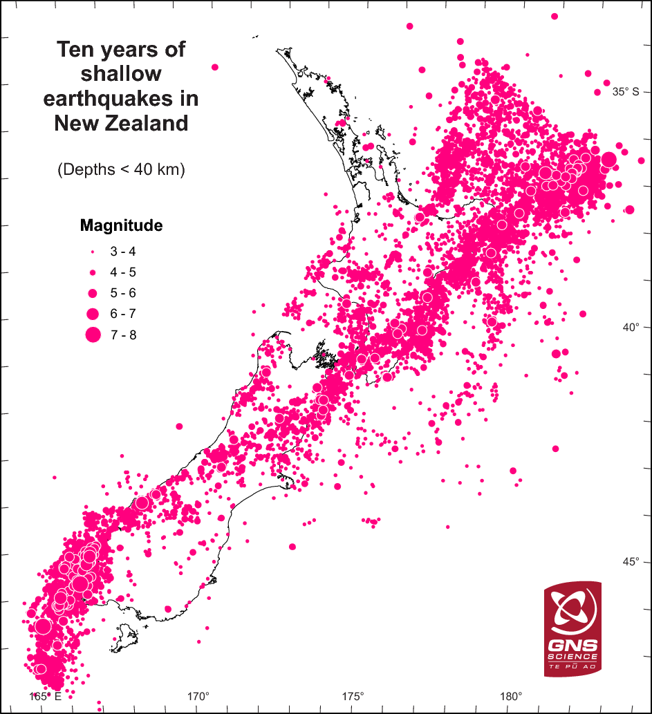
The pattern of shallow earthquakes in New Zealand. Image credit: GNS Science
Seismotectonics of the Eastern Margin of the Australia Plate
The eastern margin of the Australia plate is one of the most sesimically active areas of the world due to high rates of convergence between the Australia and Pacific plates. In the region of New Zealand, the 3000 km long Australia-Pacific plate boundary extends from south of Macquarie Island to the southern Kermadec Island chain. It includes an oceanic transform (the Macquarie Ridge), two oppositely verging subduction zones (Puysegur and Hikurangi), and a transpressive continental transform, the Alpine Fault through South Island, New Zealand.
Since 1900 there have been 15 M7.5+ earthquakes recorded near New Zealand. Nine of these, and the four largest, occurred along or near the Macquarie Ridge, including the 1989 M8.2 event on the ridge itself, and the 2004 M8.1 event 200 km to the west of the plate boundary, reflecting intraplate deformation. The largest recorded earthquake in New Zealand itself was the 1931 M7.8 Hawke's Bay earthquake, which killed 256 people. The last M7.5+ earthquake along the Alpine Fault was 170 years ago; studies of the faults' strain accumulation suggest that similar events are likely to occur again.
North of New Zealand, the Australia-Pacific boundary stretches east of Tonga and Fiji to 250 km south of Samoa. For 2,200 km the trench is approximately linear, and includes two segments where old (>120 Myr) Pacific oceanic lithosphere rapidly subducts westward (Kermadec and Tonga). At the northern end of the Tonga trench, the boundary curves sharply westward and changes along a 700 km-long segment from trench-normal subduction, to oblique subduction, to a left lateral transform-like structure.
Australia-Pacific convergence rates increase northward from 60 mm/yr at the southern Kermadec trench to 90 mm/yr at the northern Tonga trench; however, significant back arc extension (or equivalently, slab rollback) causes the consumption rate of subducting Pacific lithosphere to be much faster. The spreading rate in the Havre trough, west of the Kermadec trench, increases northward from 8 to 20 mm/yr. The southern tip of this spreading center is propagating into the North Island of New Zealand, rifting it apart. In the southern Lau Basin, west of the Tonga trench, the spreading rate increases northward from 60 to 90 mm/yr, and in the northern Lau Basin, multiple spreading centers result in an extension rate as high as 160 mm/yr. The overall subduction velocity of the Pacific plate is the vector sum of Australia-Pacific velocity and back arc spreading velocity: thus it increases northward along the Kermadec trench from 70 to 100 mm/yr, and along the Tonga trench from 150 to 240 mm/yr.
The Kermadec-Tonga subduction zone generates many large earthquakes on the interface between the descending Pacific and overriding Australia plates, within the two plates themselves and, less frequently, near the outer rise of the Pacific plate east of the trench. Since 1900, 40 M7.5+ earthquakes have been recorded, mostly north of 30°S. However, it is unclear whether any of the few historic M8+ events that have occurred close to the plate boundary were underthrusting events on the plate interface, or were intraplate earthquakes. On September 29, 2009, one of the largest normal fault (outer rise) earthquakes ever recorded (M8.1) occurred south of Samoa, 40 km east of the Tonga trench, generating a tsunami that killed at least 180 people.
Across the North Fiji Basin and to the west of the Vanuatu Islands, the Australia plate again subducts eastwards beneath the Pacific, at the North New Hebrides trench. At the southern end of this trench, east of the Loyalty Islands, the plate boundary curves east into an oceanic transform-like structure analogous to the one north of Tonga.
Australia-Pacific convergence rates increase northward from 80 to 90 mm/yr along the North New Hebrides trench, but the Australia plate consumption rate is increased by extension in the back arc and in the North Fiji Basin. Back arc spreading occurs at a rate of 50 mm/yr along most of the subduction zone, except near ~15°S, where the D'Entrecasteaux ridge intersects the trench and causes localized compression of 50 mm/yr in the back arc. Therefore, the Australia plate subduction velocity ranges from 120 mm/yr at the southern end of the North New Hebrides trench, to 40 mm/yr at the D'Entrecasteaux ridge-trench intersection, to 170 mm/yr at the northern end of the trench.
Large earthquakes are common along the North New Hebrides trench and have mechanisms associated with subduction tectonics, though occasional strike slip earthquakes occur near the subduction of the D'Entrecasteaux ridge. Within the subduction zone 34 M7.5+ earthquakes have been recorded since 1900. On October 7, 2009, a large interplate thrust fault earthquake (M7.6) in the northern North New Hebrides subduction zone was followed 15 minutes later by an even larger interplate event (M7.8) 60 km to the north. It is likely that the first event triggered the second of the so-called earthquake "doublet". (USGS) More information on regional seismicity and tectonics
Featured image credit: USGS
Commenting rules and guidelines
We value the thoughts and opinions of our readers and welcome healthy discussions on our website. In order to maintain a respectful and positive community, we ask that all commenters follow these rules.