Satellites tracking huge cloud of ash and SO2 after major eruption of Mount Kelut
After yesterday's major eruption of Indonesian Mount Kelut satellites are tracking major cloud of ash and sulphur dioxide as it spreads in the atmosphere.
The ash has reached high altitudes where commercial aircraft fly and is a significant hazard to aviation,” said Fred Prata from the Norwegian Institute for Air Research. Aviation color code is on red.
Airports across Java have closed, and multiple flights have been canceled throughout the region. Local newspapers reported heavy ash falls in areas up to 200 km distance. The explosion sound was heard in Yogyakarta (170 km distance).
“Based on verified data, over 76 000 people have been evacuated from five cities around the volcano … and about 200 000 people were affected,” National Disaster Mitigation Agency spokesman Sutopo Nugroho said in a text message.
Officials said two people died when their homes caved in under the weight of gravel and ash. (BBC)
According to VSI, the eruption started at 21:15 local time, following a rapid build-up in seismic activity during the same day. Monitoring staff were forced to evacuate their observation post as the eruption began to increase and a heavy rain of gravel-sized lapilli set in.
According to latest advisory from Darwin VAAC, issued 14:52 UTC on February 14, high level volcanic ash plume (15.2 km / 55 000 feet) has moved W from volcano.
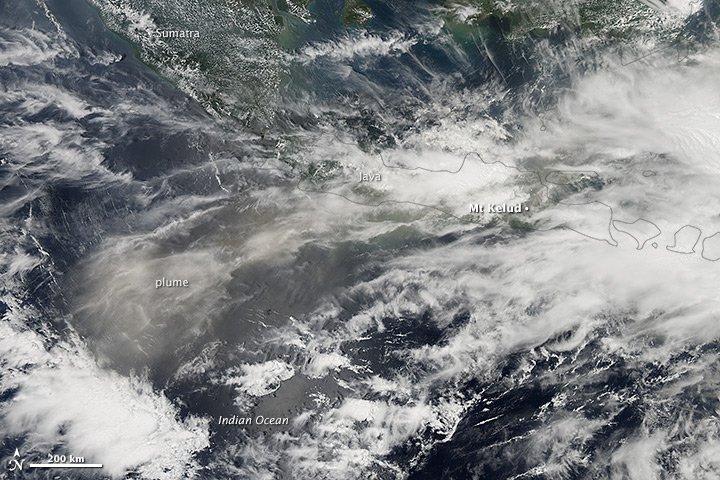
NASA Earth Observatory image by Jesse Allen, using data from the Land Atmosphere Near real-time Capability for EOS (LANCE)
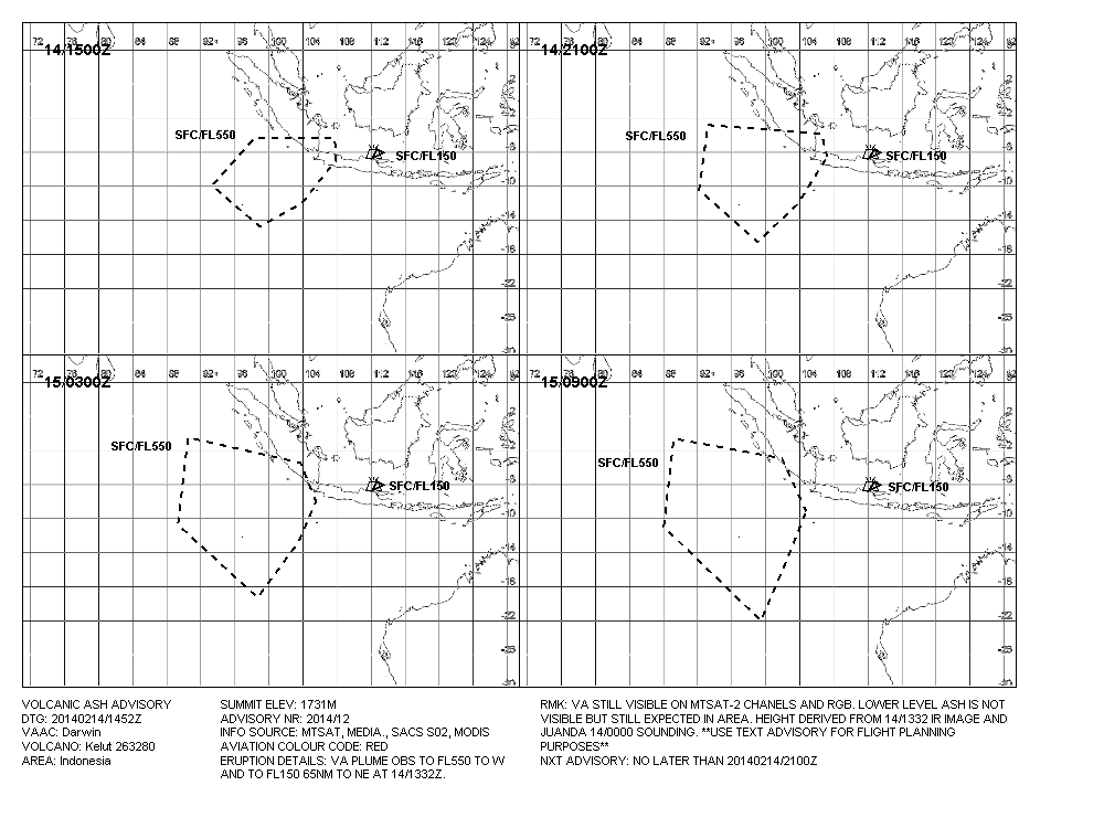
Image credit: Darwin VAAC – February 14, 2014 – 14:52 UTC


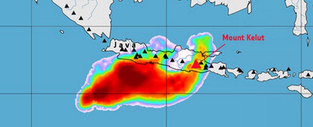
Sulphur dioxide concentration over the Indonesian island of Java in the early morning of February 14, 2014 following the eruption of the Kelut volcano. This image is based on data from the GOME-2 instrument on the MetOp mission. Image copyright: ESA/DLR/BIRA-IASB/Eumetsat – February 14, 2014.
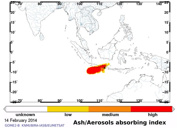
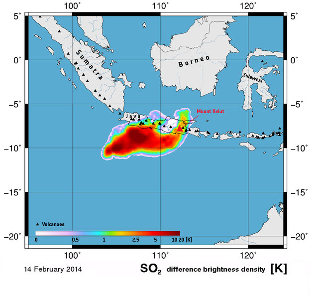
Ash information over the Indonesian island of Java on February 14, 2014 following the eruption of the Kelut volcano. This image is based on data from the GOME-2 instrument on the MetOp mission. Image copyright ESA/ ULB/BIRA-IASB/Eumetsat
More than 30 eruptions have been recorded from Kelut since 1000 AD. The ejection of water from the crater lake during Kelut's typically short, but violent eruptions has created pyroclastic flows and lahars that have caused widespread fatalities and destruction.
After more than 5000 persons were killed during an eruption in 1919, an ambitious engineering project sought to drain the crater lake. This initial effort lowered the lake by more than 50 m, but the 1951 eruption deepened the crater by 70 m, leaving 50 million cubic meters of water after repair of the damaged drainage tunnels.
After more than 200 deaths in the 1966 eruption, a new deeper tunnel was constructed, and the lake's volume before the 1990 eruption was only about 1 million cubic meters (GVP).

Featured image: Sulphur dioxide concentration over the Indonesian island of Java in the early morning of February 14, 2014 following the eruption of the Kelut volcano. This image is based on data from the GOME-2 instrument on the MetOp mission. Image copyright: ESA/DLR/BIRA-IASB/Eumetsat
Thank you very much Lulu,
The Climate change issue is controlled by politicians. In my understanding the main reason why so many scientists are following the politicians not the other way around is because of the defect in our understanding of the Sun and also its true relation with our planet.On the other hand, the scientists who are sharp and want to know the truths about climate change are suppressed by their superiors.The heads of research institutes have to be politically correct when it comes to issues that are controlled by politicians.There are so many cases and example where researchers found strong evidence that extraterrestrial factors are to blame. Those researchers are from different institutes include world famous research institutes like CERN and NASA…etc
OUTGOING…!!!
here is the amazing lightning flashes during the mt kelud eruption..
https://www.youtube.com/watch?v=31UOdPKuLlE
I agree with you jamal.
There's too much "18th century" and 'professional pride/stubbornness' thinking stifling, or suppressing, the real truth about what is really happening on this planet.
Cheers to you jamal.
I have been arguing for a few years that the cause for the rapid increase of climate change is the heat increase at the Earth's core and the rapid shifting of the earth's magnetic field which is causing the increasing in earthquakes and volcanic eruptions. The scientific community and mass media is ignoring the increase of earthquakes and volcanic eruptions and concentrating on the other climate events that can easily be blamed for human activity. Sooner or later the scientific facts that I am fighting for will be obvious to the whole world.
Jamal Shrair