Magnitude 6.5 earthquake struck east of Lesser Antilles, Puerto Rico swarm continues
USGS registered a M6.5 earthquake at a depth of 17.5 km east of Lesser Antilles (eastern boundary of the Caribbean Sea with the Atlantic Ocean) on February 18, 2014 at 09:27 UTC. EMSC is reporting Mw 6.5 at a depth of 15 km.
The picenter was located 187 km (116 miles) NNE of Bridgetown, Barbados and 203 km (126 miles) E of Le Francois, Martinique. Tsunami warnings are not in effect.
The Lesser Antilles more or less coincide with the outer edge of the Caribbean Plate. Many of the islands were formed as a result of the subduction of oceanic crust of the South American Plate under the Caribbean Plate in the Lesser Antilles subduction zone. This process is ongoing and is responsible not only for many of the islands, but also for volcanic and earthquake activity in the region.
The islands along the South American coast are largely the result of the interaction of the South American Plate and the Caribbean Plate which is mainly strike-slip, but includes a component of compression.
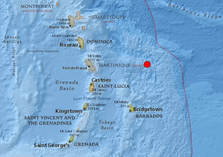
Image credit: USGS
Population exposure
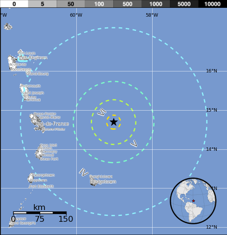
Image credit: USGS
Selected cities exposed – from GeoNames Database of Cities with 1,000 or more residents. (k = x1,000)
| MMI | City | Population |
|---|---|---|
| IV | Bridgetown | 99k |
| IV | Speightstown | 4k |
| IV | Vieux Fort | 5k |
| IV | Le Vauclin | 8k |
| IV | Welchman Hall | <1k |
| IV | Holetown | 1k |
| IV | Fort-de-France | 90k |
| IV | Roseau | 17k |
| III | Kingstown | 25k |
| III | Basse-Terre | 11k |
| III | Saint John's | 24k |
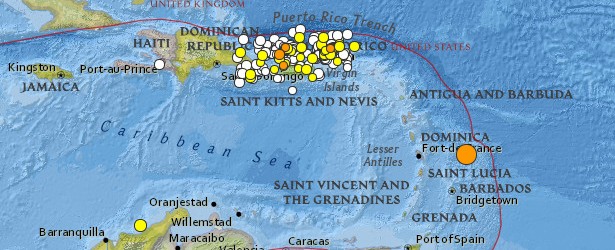
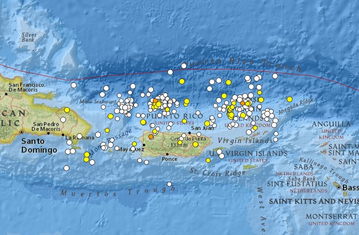
Significant Puerto Rico swarm continues
Puerto Rico is located along the Puerto Rico Trench (about 900 km NW from today's M 6.5) and is experiencing intense earthquake swarm for more than 2 months now. In last 24 hours, USGS registered 4 earthquakes with magnitudes of 2.5 and above (M 2.5+) there.
In just 7 days (January 12 – 19, 2014) USGS recorded 417 earthquakes with magnitudes 2.5 and above. The strongest was M 6.4 on January 13, 2014.
Map showing M2.5+ earthquakes in last 30 days (January 18 – February 18, 2014) – 254 earthquakes. Image credit: USGS
The Puerto Rico Trench is an oceanic trench located on the boundary between the Caribbean Sea and the Atlantic Ocean. The trench is associated with a complex transition between the Lesser Antilles subduction zone to the south and the major transform fault zone or plate boundary, which extends west between Cuba and Hispaniola through the Cayman Trench to the coast of Central America. This subduction zone explains the presence of active volcanoes over the southeastern part of the Caribbean Sea. Volcanic activity is frequent along the island arc southeast from Puerto Rico to the coast of South America.
Puerto Rico, the United States Virgin Islands, British Virgin Islands, and the Dominican Republic do not have active volcanoes; however, they are at risk from earthquakes and tsunamis. The Puerto Rico Trench is capable of producing earthquakes greater than magnitude 8.0.
Scientific studies have concluded that an earthquake occurring along this fault zone could generate a significant tsunami (NOAA).
If you are living in this area do not take this warning lightly and please take a look at this blog post.
Online Puerto Rico Seismic Network is here.
Seismotectonics of the Caribbean region and vicinity
Extensive diversity and complexity of tectonic regimes characterizes the perimeter of the Caribbean plate, involving no fewer than four major plates (North America, South America, Nazca, and Cocos). Inclined zones of deep earthquakes (Wadati-Benioff zones), ocean trenches, and arcs of volcanoes clearly indicate subduction of oceanic lithosphere along the Central American and Atlantic Ocean margins of the Caribbean plate, while crustal seismicity in Guatemala, northern Venezuela, and the Cayman Ridge and Cayman Trench indicate transform fault and pull-apart basin tectonics.
Along the northern margin of the Caribbean plate, the North America plate moves westwards with respect to the Caribbean plate at a velocity of approximately 20 mm/yr. Motion is accommodated along several major transform faults that extend eastward from Isla de Roatan to Haiti, including the Swan Island Fault and the Oriente Fault. These faults represent the southern and northern boundaries of the Cayman Trench. Further east, from the Dominican Republic to the Island of Barbuda, relative motion between the North America plate and the Caribbean plate becomes increasingly complex and is partially accommodated by nearly arc-parallel subduction of the North America plate beneath the Caribbean plate. This results in the formation of the deep Puerto Rico Trench and a zone of intermediate focus earthquakes (70-300 km depth) within the subducted slab. Although the Puerto Rico subduction zone is thought to be capable of generating a megathrust earthquake, there have been no such events in the past century. The last probable interplate (thrust fault) event here occurred on May 2, 1787 and was widely felt throughout the island with documented destruction across the entire northern coast, including Arecibo and San Juan. Since 1900, the two largest earthquakes to occur in this region were the August 4, 1946 M8.0 Samana earthquake in northeastern Hispaniola and the July 29, 1943 M7.6 Mona Passage earthquake, both of which were shallow thrust fault earthquakes. A significant portion of the motion between the North America plate and the Caribbean plate in this region is accommodated by a series of left-lateral strike-slip faults that bisect the island of Hispaniola, notably the Septentrional Fault in the north and the Enriquillo-Plantain Garden Fault in the south. Activity adjacent to the Enriquillo-Plantain Garden Fault system is best documented by the devastating January 12, 2010 M7.0 Haiti strike-slip earthquake, its associated aftershocks and a comparable earthquake in 1770.
Moving east and south, the plate boundary curves around Puerto Rico and the northern Lesser Antilles where the plate motion vector of the Caribbean plate relative to the North and South America plates is less oblique, resulting in active island-arc tectonics. Here, the North and South America plates subduct towards the west beneath the Caribbean plate along the Lesser Antilles Trench at rates of approximately 20 mm/yr. As a result of this subduction, there exists both intermediate focus earthquakes within the subducted plates and a chain of active volcanoes along the island arc. Although the Lesser Antilles is considered one of the most seismically active regions in the Caribbean, few of these events have been greater than M7.0 over the past century. The island of Guadeloupe was the site of one of the largest megathrust earthquakes to occur in this region on February 8, 1843, with a suggested magnitude greater than 8.0. The largest recent intermediate-depth earthquake to occur along the Lesser Antilles arc was the November 29, 2007 M7.4 Martinique earthquake northwest of Fort-De-France.
The southern Caribbean plate boundary with the South America plate strikes east-west across Trinidad and western Venezuela at a relative rate of approximately 20 mm/yr. This boundary is characterized by major transform faults, including the Central Range Fault and the Boconó-San Sebastian-El Pilar Faults, and shallow seismicity. Since 1900, the largest earthquakes to occur in this region were the October 29, 1900 M7.7 Caracas earthquake, and the July 29, 1967 M6.5 earthquake near this same region. Further to the west, a broad zone of compressive deformation trends southwestward across western Venezuela and central Columbia. The plate boundary is not well defined across northwestern South America, but deformation transitions from being dominated by Caribbean/South America convergence in the east to Nazca/South America convergence in the west. The transition zone between subduction on the eastern and western margins of the Caribbean plate is characterized by diffuse seismicity involving low- to intermediate-magnitude (M<6.0) earthquakes of shallow to intermediate depth.
The plate boundary offshore of Colombia is also characterized by convergence, where the Nazca plate subducts beneath South America towards the east at a rate of approximately 65 mm/yr. The January 31, 1906 M8.5 earthquake occurred on the shallowly dipping megathrust interface of this plate boundary segment. Along the western coast of Central America, the Cocos plate subducts towards the east beneath the Caribbean plate at the Middle America Trench. Convergence rates vary between 72-81 mm/yr, decreasing towards the north. This subduction results in relatively high rates of seismicity and a chain of numerous active volcanoes; intermediate-focus earthquakes occur within the subducted Cocos plate to depths of nearly 300 km. Since 1900, there have been many moderately sized intermediate-depth earthquakes in this region, including the September 7, 1915 M7.4 El Salvador and the October 5, 1950 M7.8 Costa Rica events.
The boundary between the Cocos and Nazca plates is characterized by a series of north-south trending transform faults and east-west trending spreading centers. The largest and most seismically active of these transform boundaries is the Panama Fracture Zone. The Panama Fracture Zone terminates in the south at the Galapagos rift zone and in the north at the Middle America trench, where it forms part of the Cocos-Nazca-Caribbean triple junction. Earthquakes along the Panama Fracture Zone are generally shallow, low- to intermediate in magnitude (M<7.2) and are characteristically right-lateral strike-slip faulting earthquakes. Since 1900, the largest earthquake to occur along the Panama Fracture Zone was the July 26, 1962 M7.2 earthquake. (USGS) – More information on regional seismicity and tectonics.
References for the Panama Fracture Zone:
Molnar, P., and Sykes, L. R., 1969, Tectonics of the Caribbean and Middle America Regions from Focal Mechanisms and Seismicity: Geological Society of America Bulletin, v. 80, p. 1639-1684.
Featured image: USGS
let's get ready to rumble