Ex-Tropical Cyclone Gillian forecast to re-intensify as it approaches Christmas Island
Ex-Tropical Cyclone Gillian is showing signs of intensification and is forecast to re-intensify into a tropical cyclone overnight as it approaches Christmas Island.
This has increased the risk of damaging winds (gale force winds) at Christmas Island. It is now also possible that destructive wind gusts (wind gusts in excess of 125 km/h) could occur on Christmas Island if the system continues to intensify and passes close to Christmas Island.
Gales are not expected to affect the island Friday night but are more likely to first develop early Saturday morning. The period of greatest risk is now expected to commence during Saturday and continue into Sunday, the Australian Government Bureau of Meteorology reports.
At 9:00 UTC today (16:00 CXT / local time on Christmas Island) Ex-Tropical Cyclone Gillian, was estimated to be 255 kilometers east northeast of Christmas Island and moving west at 30 kilometres per hour.
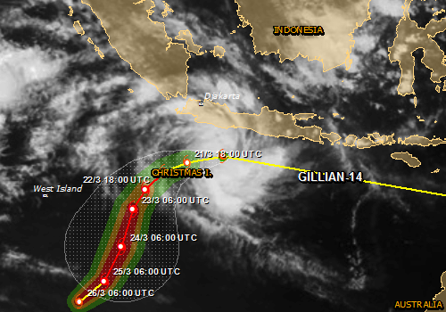
Remnants of ex TC Gillian – Forecast track. Image credit: JRC
NASA's TRMM satellite continues to follow the remnants of TC Gillian as it moved from the Southern Pacific Ocean into the Southern Indian Ocean. The persistent remnants have moved westward over 2 700 km/1 674 miles since forming in the Gulf of Carpentaria on March 8, 2014.
Gillian's coherent remnants were located just to the southeast of the Indonesian island of Java when the Tropical Rainfall Measuring Mission or TRMM satellite flew overhead on March 20, 2014 at 04:15 UTC.

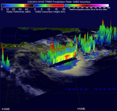
3D TRMM image of ex TC Gillian. TRMM data showed several of the tallest thunderstorms in Gillian's remnants were reaching heights of over 15.75 km/9.8 miles. Credit: NASA/SSAI, Hal Pierce
TRMM's Precipitation Radar (PR) instrument revealed that intense convective storms in this area were still dropping rain at a rate of over 97 mm/3.8 inches per hour and returning radar reflectivity values of over 51dBZ. TRMM PR data were used to create a simulated 3-D view that showed the vertical structure of precipitation within the stormy area contained towering thunderstorms.
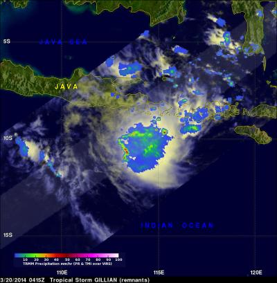
On March 20, NASA's TRMM satellite saw that some thunderstorms within Gillian's remnants were dropping rain at a rate of over 97 mm/3.8 inches per hour. Credit: NASA/SSAI, Hal Pierce
Heavy rainfall is likely on Christmas Island during Saturday and Sunday.
Featured image: NASA/SSAI
Commenting rules and guidelines
We value the thoughts and opinions of our readers and welcome healthy discussions on our website. In order to maintain a respectful and positive community, we ask that all commenters follow these rules:
We reserve the right to remove any comments that violate these rules. By commenting on our website, you agree to abide by these guidelines. Thank you for helping to create a positive and welcoming environment for all.