Epic time-lapse of supercell storm cloud formation
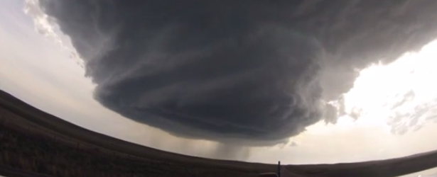
A group of stormchasers called "Basehunters" have released two awesome videos of supercell cloud storms formed in northeast Wyoming (U.S.) over the last two days. Supercell storm clouds are rare, beautiful and extremely dangerous.
The first video was taken on May 18, 2014 while the group was driving from Wright to Newcastle. It went viral on the first day and by mid May 20 (UTC time), it got more than 3 million views. The video captures both formation and dissipation of the supercell.

May 18, 2014. Video courtesy of Basehunters
This next video was taken on May 19 while driving from Bridgeport to Sidney.

May 19, 2014. Video courtesy of Basehunters
A supercell is a thunderstorm that is characterized by the presence of a mesocyclone: a deep, persistently rotating updraft. They can occur anywhere in the world under the right weather conditions but are most common in the Great Plains of the United States in an area known as Tornado Alley and in the plains of Argentina, Uruguay and southern Brazil.
Of the four classifications of thunderstorms (supercell, squall line, multi-cell, and single-cell), supercells are the overall least common and have the potential to be the most severe.
Featured image credit: Basehunters
Commenting rules and guidelines
We value the thoughts and opinions of our readers and welcome healthy discussions on our website. In order to maintain a respectful and positive community, we ask that all commenters follow these rules:
We reserve the right to remove any comments that violate these rules. By commenting on our website, you agree to abide by these guidelines. Thank you for helping to create a positive and welcoming environment for all.