New eruption of Pavlof volcano, ash up to 6.7km – Alaska
The low-level eruption of Pavlof volcano that started on May 31, 2014, has escalated late on June 2. According to Alaska Volcano Observatory (AVO), the seismic tremor increased starting about 23:00 UTC and pilots have recently reported ash clouds to 6.7 km (22 000 ft) above sea level. Aviation color code was raised to red.
Elevated surface temperatures were detected at the summit of Pavlof volcano in satellite imagery on May 31 suggesting that the volcano was experiencing a low-level eruption with lava at the surface. A low level steam plume was visible in satellite imagery and in the FAA web camera located in Cold Bay, AVO said. A pilot reported a gas and ash plume drifting north at 2.1 – 2.4 km (7 000 to 8 000 feet) above sea level.
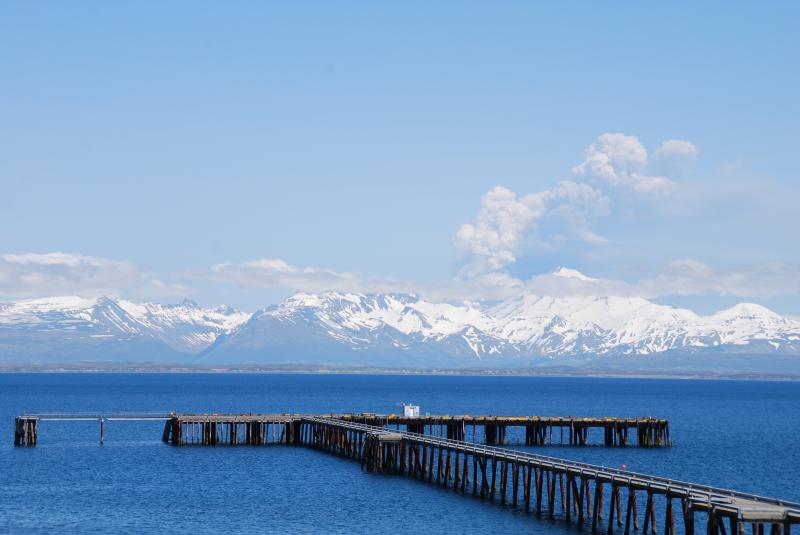
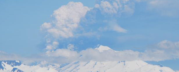
Eruption of Pavlof volcano on June 2, 2014. Image copyright Christopher Diaz at northernXposed Photography.
Satellite images acquired on June 2 show a plume extending over 80 km east of the volcano.
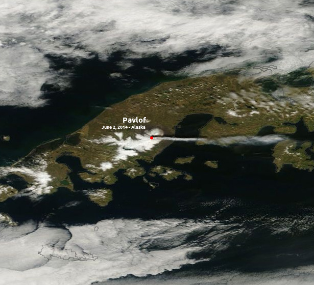
Pavlof volcano eruption. Image acquired: June 2, 2014. Image credit: NASA Terra/MODIS
The volcano has been relatively calm since its last eruptive episode in May/June 2013.
Pavlof last appeared in GVP's weekly volcanic report during the week of August 7 – 13: 7 August-13 August 2013:
"On August 8 AVO reported that no lava or ash emissions had been observed at Pavlof since June 26 and the volcano exhibited gradually declining levels of unrest. Seismicity was at background levels."
Geologic summary
The most active volcano of the Aleutian arc, Pavlof is a 2519-m-high Holocene stratovolcano that was constructed along a line of vents extending NE from the Emmons Lake caldera. Pavlof and its twin volcano to the NE, 2142-m-high Pavlof Sister, form a dramatic pair of symmetrical, glacier-covered stratovolcanoes that tower above Pavlof and Volcano bays. A third cone, Little Pavlof, is a smaller volcano on the SW flank of Pavlof volcano, near the rim of Emmons Lake caldera.

Pavlof volcano and eruption plume on evening of August 30, 2007. View is to the S, out of the right side of a PenAir Metro Airline plane en route to Anchorage from Cold Bay; plume height was approximately 5.2-5.5 km. (Courtesy of Chris Waythomas and AVO/USGS)
Unlike Pavlof Sister, Pavlof has been frequently active in historical time, typically producing strombolian to vulcanian explosive eruptions from the summit vents and occasional lava flows. The active vents lie near the summit on the north and east sides. The largest historical eruption of Pavlof took place in 1911, at the end of a 5-year-long eruptive episode. During this eruption a fissure opened on the northern flank of the volcano, ejecting large blocks and issuing lava flows. (GVP)

Index map showing location of Pavlof volcano and other Alaska Peninsula volcanoes. (Credit: Snedigar, Schaefer/Image courtesy of the AVO/ADGGS)
Featured image: Eruption of Pavlof Volcano. Image copyright Christopher Diaz at northernXposed Photography. June 2, 2014.
Commenting rules and guidelines
We value the thoughts and opinions of our readers and welcome healthy discussions on our website. In order to maintain a respectful and positive community, we ask that all commenters follow these rules:
We reserve the right to remove any comments that violate these rules. By commenting on our website, you agree to abide by these guidelines. Thank you for helping to create a positive and welcoming environment for all.