Tropical Cyclone “Nanauk” intensifies in Arabian Sea
Tropical Cyclone 02A, formed in the Arabian Sea on June 10, 2014, consolidated and strengthened into a tropical storm named "Nanauk" by June 11th. Forecasters at the Joint Typhoon Warning Center (JTWC) expect Nanauk to continue strengthening for another day and a half before running into higher wind shear and dry air as it approaches the Arabian Peninsula.
Nanauk is expected to hit the coast of Oman between Ras Al Hadd and Ras Madrakah on June 15, according to Oman's Directorate General of Meteorology and Air Navigation (DGMAN) and Public Authority for Civil Aviation (PACA).
Although the system will weaken by the time it reaches land, a senior official of the DGMAN said the storm is expected to bring in 100 – 300 mm rainfall in 24 hours all over the Sultanate, adding the height of the sea waves may reach four meters. Wind speeds are expected to reach 30 – 35 knots (55 – 64 km/h, 34 – 40 mph).
M. Mohapatra, a scientist at the Cyclone Warning Division, India Meteorological Department (IMD), said that the cyclones are not frequent in Oman. "In recent years, the cyclone Gonu in June, 2007 and Phet in June, 2010 had crossed the Oman coast. Both occurred in the first week of June.These cyclones develop during the onset and withdrawal of monsoon over the Arabian Sea," he told Times of Oman from New Delhi.

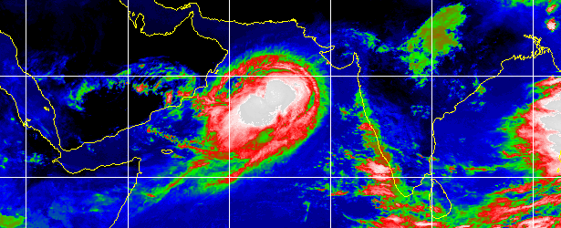
Infrared image on June 12, 2014 at 06:00 UTC. Image credit: UW-CIMSS / Meteosat-7
The fishermen have been advised against venturing into the sea when the tropical storm hits. There will also be a tidal surge along with the strong wind, the official at DGMAN said.
People have been advised against venturing into wadis (valley/channel of a watercourse that is dry except during periods of rainfall) which are prone to flash floods. The heavy rains will also significantly bring down the temperature in some areas of Oman.
NASA's Aqua satellite passed over Nanauk on June 11 at 08:29 UTC and the Atmospheric Infrared Sounder (AIRS) captured a near-infrared image of the storm providing an almost visible look at the clouds that revealed a well-rounded tropical cyclone with good circulation.
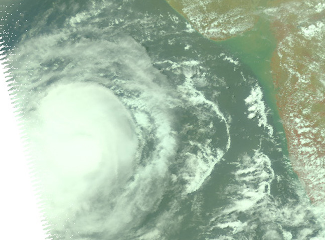
This near infrared image of Tropical Cyclone Nanauk was taken by the AIRS instrument aboard NASA's Aqua satellite on June 11 at 08:29 UTC. Image credit: NASA JPL, Ed Olsen
At 03:00 today, Tropical Cyclone "Nanauk" was located approximately 380 NM (703 km, 437 miles) east-southeast of Masirah Island, and has tracked west-northwestward at 9 knots (16.6 km/h, 10.3 mph) over the past six hours. Animated infrared satellite imagery depicts expansive area of deep convection associated with a slowly-developing low-level circulation center (LLCC). Upper-level analysis indicates the strong (30 knot) easterly vertical wind shear (VWS) is significantly hindering the development, leading to a reduction of forecast intensity from previous forecast.
However, warm sea surface temperatures and fair equatorward outlow is expected to persist, allowing Nanauk to peak at 65 knots (120 km/h, 74 miles) over the next 24 hours.
The system is forecast to continue tracking west-northwestward. After 24 hours, persistent moderate to strong VWS and possible dry air entrainment will weaken it quickly leading to dissipation in next 4 days.
Maximum significant wave height at 00:00 UTC today was 5.5 meters (18 feet). (JTWC warning at 03:00 UTC on June 12, 2014)
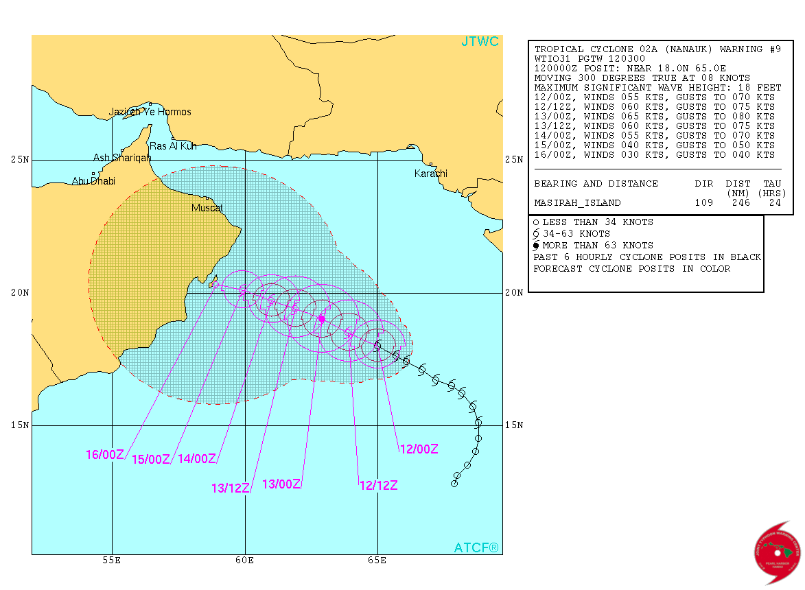
Tropical Cyclone "Nanauk" forecast track on June 12, 2014. Image credit: JTWC
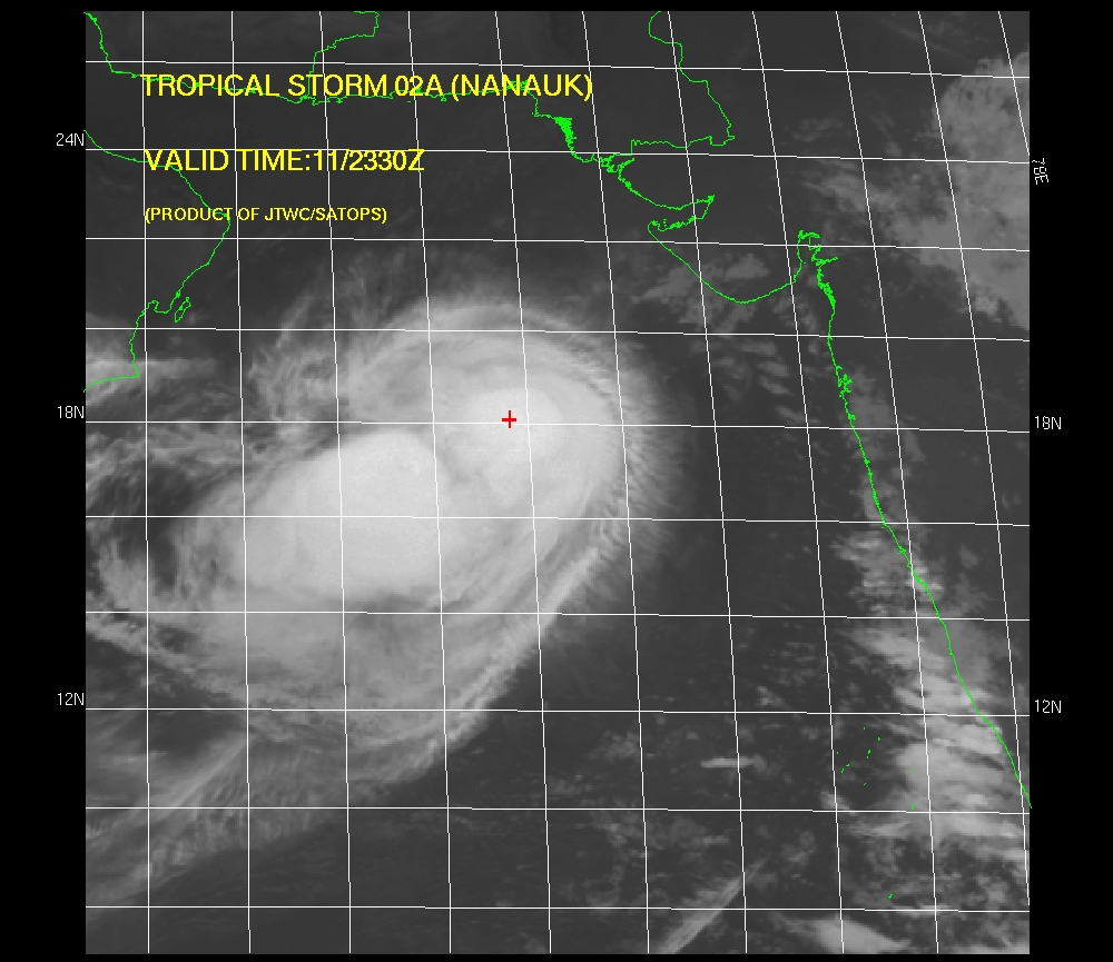
Tropical Cyclone "Nanauk" IR satellite imagery. Image credit: JTWC/SATOPS
Featured image: Infrared image on June 12, 2014 at 06:00 UTC. Image credit: UW-CIMSS / Meteosat-7
Commenting rules and guidelines
We value the thoughts and opinions of our readers and welcome healthy discussions on our website. In order to maintain a respectful and positive community, we ask that all commenters follow these rules:
We reserve the right to remove any comments that violate these rules. By commenting on our website, you agree to abide by these guidelines. Thank you for helping to create a positive and welcoming environment for all.