Satellite animation of storms that flooded the Midwestern U.S.
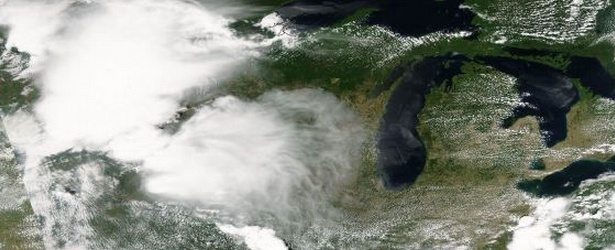
From June 16 through June 23 a series of thunderstorms dropped large amounts of rainfall on the Upper Midwest that caused flooding and spawned tornadoes. Visible and infrared data from NOAA's GOES-East satellite covering that period of time were compiled into an animation that showed the storms moving through the region each day.
NOAA's GOES-East satellite sits in a fixed orbit in space capturing visible and infrared imagery of weather over the eastern U.S. and Atlantic Ocean.

To create the video and imagery, NASA/NOAA's GOES Project takes the cloud data from NOAA's GOES-East satellite and overlays it on a true-color image of land and ocean created by data from the Moderate Resolution Imaging Spectroradiometer (MODIS) instrument that flies aboard NASA's Aqua and Terra satellites. Together, those data created the entire picture of the storm system and show its movement.
Twin tornadoes caused extensive damage in the town of Pilger, Nebraska on June 16 and the National Weather Service also received unconfirmed tornado reports from Iowa, Wisconsin and North Dakota.
Flooding was reported from Canada to Missouri and Iowa from eight days of storms. Minnesota reported extensive flooding. The Mississippi River rose to an almost 20-foot crest in St. Paul. The Crow River in Delano, Minnesota crested at 21 feet on July 23.
On June 25, the National Weather Service for the Twin Cities in Chanhassen, Minnesota posted another another flood warning for various rivers in Minnesota and Wisconsin. The warning noted "These river forecasts are based on heavy precipitation that fell during the past 7 days and the resulting runoff that is moving its way through the river system…as well as less than one tenth of an inch of precipitation that is expected during the next 24 hours."
GOES satellites provide the kind of continuous monitoring necessary for intensive data analysis. Geostationary describes an orbit in which a satellite is always in the same position with respect to the rotating Earth. This allows GOES to hover continuously over one position on Earth's surface, appearing stationary. As a result, GOES provide a constant vigil for the atmospheric "triggers" for severe weather conditions such as tornadoes, flash floods, hail storms and hurricanes.
Source: NASA / GODDARD
Featured image: NASA / Aqua MODIS on June 16, 2014.
Commenting rules and guidelines
We value the thoughts and opinions of our readers and welcome healthy discussions on our website. In order to maintain a respectful and positive community, we ask that all commenters follow these rules:
We reserve the right to remove any comments that violate these rules. By commenting on our website, you agree to abide by these guidelines. Thank you for helping to create a positive and welcoming environment for all.