Mount Sinabung erupts again, Indonesia
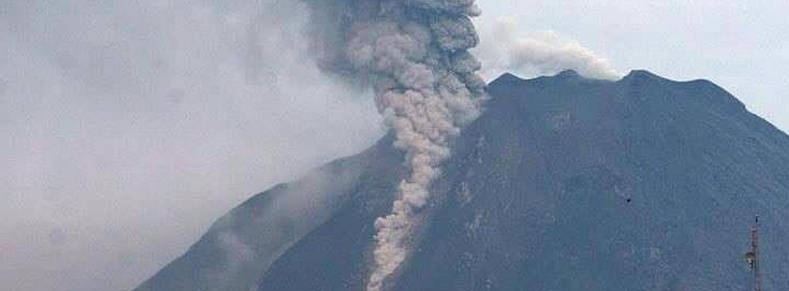
After 3 months of being relatively quiet Indonesian Mount Sinabung erupted again on September 23, 2014, spewing hot ash up to two km to the southeast, official said. The eruption started at 13:43 local time on September 24 (06:43 UTC) and lasted for a full 907 seconds, or just over 15 minutes – about 0.0028% of the year since it first started acting up.
Sutopo Purwo Nugroho, spokesman of the national disaster management agency, said the height of the ash could not be seen as it was covered by clouds. "The eruption did not trigger evacuation, but all residents in three villages near the volcano are prepared for displacement."
The Indonesian Transport Ministry warned flights to stay away from the path near the volcano.
Se registra erupción del monte #Sinabung de #Indonesia http://t.co/xTfejhj71Q pic.twitter.com/iBQrHolBQi
— FOROtv (@Foro_TV) September 24, 2014
Daily eruptions, which started last November and lasted for months, coated the countryside in gray ash two kilometers to south east and forced tens of thousands of people from their villages.
More than 30 000 villagers living within five kilometers of the peak were eventually evacuated following Sinabung's latest powerful eruption on June 29, with most taking refuge in houses of worship and event halls. Earlier this week, more than 2 000 of those refugees finally went home while 4 729 evacuees still live in shelters.
Those who remain outside their homes are currently staying in 17 evacuation shelters. Outside of the centers, the government has provided temporary housing on farmland to nearly 6 179 people. Three villages are being permanently relocated by the government, which says it’s still in the process of “land preparation.”
#Sinabung #volcano in #Indonesia erupted again, emitting ashes up to 2 kms into the sky Photo by antaraphoto pic.twitter.com/n6G3O5nOPq
— Roberto Lopez (@Bromotengger) September 24, 2014
PVMBG reported that RSAM values from Sinabung were low and stable during September 12 – 20, 2014. Earthquake signals indicating lava-dome instability were recorded and had increased from 96 to 110 events/day since September 5 – 11. Seismicity also continued to signify growth of the main lava flow on the flanks; incandescent lava was visible at the top, middle, and front of the lava flow.
The length of the lava flow was 2.9 km on September 6. White and sometimes bluish plumes rose as high as 1 km above the lava dome. Pyroclastic flows traveled 2.5 km SE on September 15 and 2 km S on September 18.
Mount Sinabung in Karo district was erupting on and off from September 2013 to February 2014, which left 15 people dead and more than 30 000 other internally displaced.
Geologic summary
Gunung Sinabung is a Pleistocene-to-Holocene stratovolcano with many lava flows on its flanks. The migration of summit vents along a N-S line gives the summit crater complex an elongated form. The youngest crater of this conical, 2460-m-high andesitic-to-dacitic volcano is at the southern end of the four overlapping summit craters.
An unconfirmed eruption was noted in 1881, and solfataric activity was seen at the summit and upper flanks of Sinabung in 1912. No confirmed historical eruptions were recorded prior to explosive eruptions during August-September 2010 that produced ash plumes to 5 km above the summit. (GVP)
Featured image: Mount Sinabung eruption on September 23/24, 2014. Image credit: AntaraPhoto
Commenting rules and guidelines
We value the thoughts and opinions of our readers and welcome healthy discussions on our website. In order to maintain a respectful and positive community, we ask that all commenters follow these rules:
We reserve the right to remove any comments that violate these rules. By commenting on our website, you agree to abide by these guidelines. Thank you for helping to create a positive and welcoming environment for all.