Super Typhoon “Vongfong” becomes the strongest tropical cyclone of the year
.jpg)
Super Typhoon "Vongfong" has become the strongest tropical cyclone of 2014. According to Joint Typhoon Warning Center (JTWC) Super Typhoon "Vongfong" reached maximum sustained winds of 288 km/h (180 mph) with gusts up to 352 km/h (218 mph) around 18:00 UTC on October 8, 2014.
Continued low vertical wind shears and passage over very warm sea surface temperatures allowed the system to reach peak intensity and estimated central pressure of 900 millibars (the lowest pressure of any typhoon they have rated since Super Typhoon Haiyan's 895 mb pressure recorded at November 7, 2013.
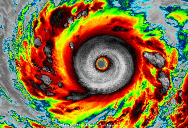
Infrared VIIRS image of Super Typhoon Vongfong captured at 17:03 UTC on October 7, 2014 when Vongfong was a peak-intensity Category 5 storm with 288 km/h (180 mph) winds. (redit: Dan Lindsey, NOAA/NASA and RAMMB/CIRA.)
Vongfong is the fifth super typhoon of 2014. It is also the strongest tropical cyclone after destructive Super Typhoon "Haiyan", which killed over 6 000 people in Philippines in November 2013 with maximum sustained winds of 315 km/h (195 mph). It is estimated that between 2000 – 2013, Earth averaged five Category 5 storms per year, with 51% of these occurring in the Western Pacific.
.jpg)
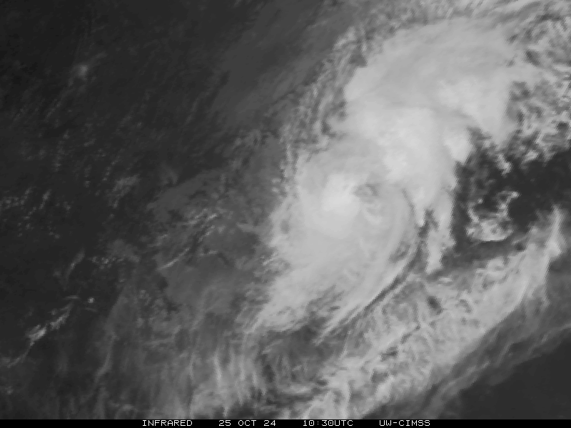
MTSAT IR satellite image taken at 14:32 UTC on October 8, 2014. (Credit: NOAA/UW-CIMSS)
According to public advisory issued by Joint Typhoon Warning Center (JTWC) at 15:00 UTC on October 8, 2014, the center of Super Typhoon "Vongfong" was located approximately 510 nm south-southeast of Kadena AB, and was moving northwestward at speed of 13 km/h (8 mph). Maximum sustained wind is assessed at 270 km/h (168 mph) with gusts up to 325 km/h (202 mph).
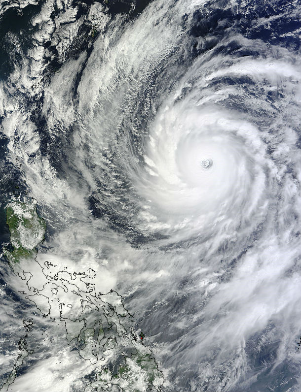
Terra/MODIS satellite image of Super Typhoon Vongfong taken at 02:15 UTC on October 8, 2014. (Credit: LANCE Rapid Response/MODIS)
Cooler waters and higher wind shear will weaken the system by October 10, as the typhoon approaches Japan. Vongfong is predicted to make landfall somewhere on the main island of Kyushu around October 10/11, 2014. After that, Vongfong is forecast to re-curve northeastward as it begins to interact with the midlatitude westerlies and begin extra- tropical transition.
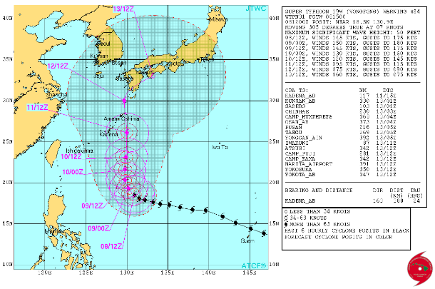
Super Typhoon Vongfong forecast track (Credit: JTWC)
.jpg)
Satellite animations
- Storm-Centered Infrared (Meteosat 7; CIMSS)
- Storm-Centered Enhanced Infrared (Meteosat 7; CIMSS)
- Storm-Centered Water Vapor (Meteosat 7; CIMSS)
- Storm-Centered Visible (Meteosat 7; CIMSS)
- Storm-Centered Infrared (MTSAT2; NOAA/SSD)
- Storm-Centered Infrared (Aviation Color Enhancement) (MTSAT2; NOAA/SSD)
- Storm-Centered Water Vapor (MTSAT2; NOAA/SSD)
- Storm-Centered Visible (MTSAT2; NOAA/SSD)
- Storm-Centered Visible (Colorized) (MTSAT2; NOAA/SSD)
- Meteosat 7 Infrared
- Meteosat 7 Infrared (Color Background)
- Meteosat 7 Infrared (NHC Color Enhancement)
- Meteosat 7 Water Vapor
- Meteosat 7 Water Vapor (Color Background)
Commenting rules and guidelines
We value the thoughts and opinions of our readers and welcome healthy discussions on our website. In order to maintain a respectful and positive community, we ask that all commenters follow these rules:
We reserve the right to remove any comments that violate these rules. By commenting on our website, you agree to abide by these guidelines. Thank you for helping to create a positive and welcoming environment for all.