Typhoon “Vongfong” about to make landfall at Kyushu, Japan
Typhoon "Vongfong" is nearing southern Japan island of Kyushu and is about to make landfall as Category 1 typhoon. According to report issued by Japan Meteorological Agency (JMA) at 22:45 UTC on October 12, 2014, Vongfong developed maximum sustained winds of 120 km/h (75 mph) with gusts up to 175 km/h (109 mph).
.jpg)
Aqua/MODIS satellite image of Typhoon Vongfong at 05:00 UTC on October 12, 2014. (Credit: LANCE Rapid Response/MODIS)
Vongfong already brought flooding rainfall and damaging wind to the northern Mariana Islands last weak. Wind gusts over 90 km/h (55 mph) with rainfall over 75 millimeters (3 inches). Vongfong gain more strength and reached super typhoon status with sustained winds of 288 km/h (180 mph) and gusts up to 352 km/h (218 mph) on October 8, 2014.
The system gradually weakened and slammed the Ryukyu Islands of southern Japan, with sustained winds of 180 km/h (112 mph) recorded in Okinawa on October 11, 2014. Nearly 500 mm (20 inches) of rain fell at nearby Kunigami on October 11, 2014. It continued to weaken early on October 12 morning as it moved north towards Kagoshima in Kyushu and Shikoku.
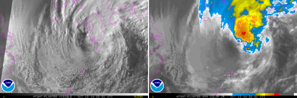
MTSAT visible and AVN IR satellite images of Typhoon Vongfong at 22:01 UTC on October 12, 2014. (Credit: NOAA/MTSAT)
.png)
MTSAT RBTOP IR satellite image of Typhoon Vongfong at 22:01 UTC on OCtober 12, 2014. (Credit: NOAA/MTSAT)
Vongfong will make landfall across Kyushu, before accelerating across Honshu and emerging out into the northern West Pacific on October 14, 2014. The system will bring life-threatening conditions to most of Japan with the greatest impacts expected in Kyushu, Shikoku and southern Honshu.
High risk of flooding will combine with damaging wind gusts. Vongfong already dumped 64 millimeters of rain in Muroto City, Kochi Prefecture. Over 500 mm (20 inches) of rainfall is expected in some of the mountainous terrain which will lead to flooding and mudslides. Japan is still recovering from impact of Typhoon Phanfone.
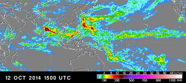
Global rainfall accumulation at 15:00 UTC on October 12, 2014. (Credit: NASA/TRMM)
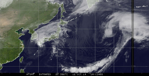
MTSAT IR satellite image taken at 21:30 UTC on OCtober 12, 2014. (Credit: NOAA/UW-CIMSS)
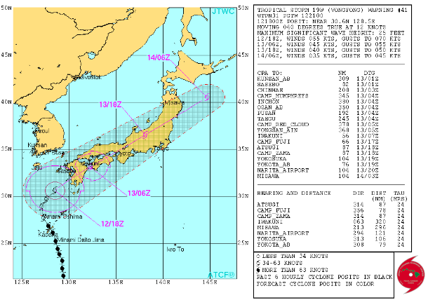
Typhoon Vongfong forecast track (Credit: JTWC)
Satellite animations
- Storm-Centered Infrared (MTSAT2; NOAA/SSD)
- Storm-Centered Infrared (Aviation Color Enhancement) (MTSAT2; NOAA/SSD)
- Storm-Centered Water Vapor (MTSAT2; NOAA/SSD)
- Storm-Centered Visible (MTSAT2; NOAA/SSD)
- Storm-Centered Visible (Colorized) (MTSAT2; NOAA/SSD)
- Storm-Centered Infrared (MTSAT2; CIMSS)
- Storm-Centered Enhanced Infrared (MTSAT2; CIMSS)
- Storm-Centered Water Vapor (MTSAT2; CIMSS)
- Storm-Centered Visible (MTSAT2; CIMSS)
- Northwest Pacific Infrared (MTSAT2; NOAA/SSD)
- Northwest Pacific Infrared (Aviation Color Enhancement) (MTSAT2; NOAA/SSD)
- Northwest Pacific Water Vapor (MTSAT2; NOAA/SSD)
- Northwest Pacific Visible (MTSAT2; NOAA/SSD)
- Northwest Pacific Visible (Colorized) (MTSAT2; NOAA/SSD)
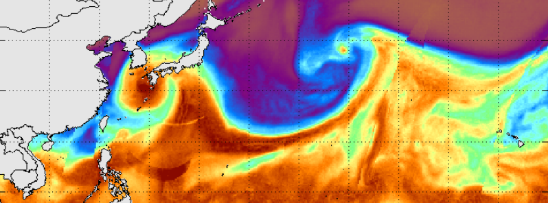
.jpg)
Featured image: Total Precipitable Water – West Pacific at 22:55 UTC on October 12, 2014. (MIMIC-SSMI/SSMIS/TMI)
Commenting rules and guidelines
We value the thoughts and opinions of our readers and welcome healthy discussions on our website. In order to maintain a respectful and positive community, we ask that all commenters follow these rules:
We reserve the right to remove any comments that violate these rules. By commenting on our website, you agree to abide by these guidelines. Thank you for helping to create a positive and welcoming environment for all.