Lava flow from Kilauea approaching residential properties, Hawaii
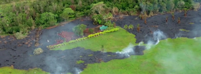
Hawaiian Kīlauea continues to erupt at its summit and within the East Rift Zone with elevated gas emissions. Currently, the June 27th lava flow is advancing northeast between Apa`a St/Cemetery Rd and Pāhoa Village Road.
As of 02:30 UTC today (16:30 local time on October 27), the flow was 510 meters (560 yards) upslope from Pāhoa Village Road. The flow width was about 50 meters (55 yards) at the leading edge.
HVO update issued at 03:51 UTC today said the advance rate of the narrow leading edge varied between 7 and 10 meters (8 and 11 yards) per hour on October 27, which is equivalent to 170 and 240 meters (185 and 260 yards) per day.
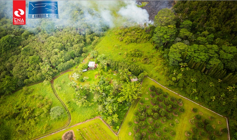
Aerial photo of the lava flow approaching a residential home in Pahoa on October 27. Image courtesy ‘Ena Media Hawai’i/Blue Hawaiian Helicopters.
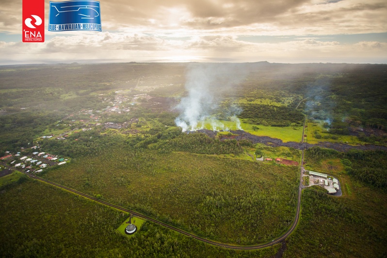
According to Hawai`i County Civil Defense warning message issued 04:00 UTC today, the lava flow front is approximately 64 meters (70 yards) from the nearest residential property.
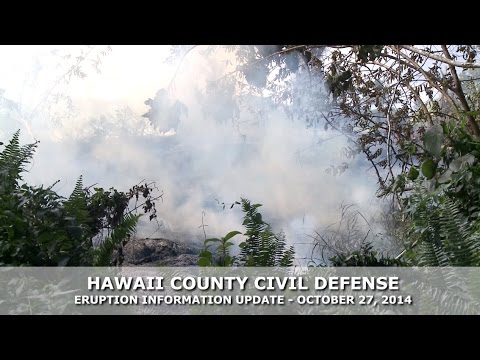
"Smoke conditions were light to moderate with moderate trade winds from the northeast pushing the smoke in a south southwest direction. Smoke conditions may increase in some areas and residents down wind that may be sensitive or have respiratory problems are advised to take necessary precautions and to remain indoors.
Based on the current flow location, direction and advancement, residents in the flow path were placed on an evacuation advisory and notified of possible need for evacuation beginning last night. The evacuation advisory for those residents down slope of the flow will continue and residents will be kept informed of the flow status and advancement.
The Pahoa Village Road between Apa’a Street and the Post Office Road will remain closed and limited to area residents only. In addition, Civil Defense and public safety personnel will be operating in the area round the clock to maintain close observations of flow activity. Additional updates will be broadcasted as conditions change."
Aerial photo of the lava flow approaching a residential home in Pahoa on October 27. Image courtesy ‘Ena Media Hawai’i/Blue Hawaiian Helicopters.
The Hawaii State Department of Education (DOE) is closing some schools ahead of the rapidly advancing lava flow. The pace of the flow has accelerated the implementation of DOE’s contingency plans, which will affect about 1 700 students and 300 employees beginning this week.
The Hawaii County Department of Water Supply will be shutting valves on each side of the lava flow once it reaches Pahoa Village Road. This will result in a drop in pressure for some customers north of the lava including Āpa‘a Street as well as along Highway 130 from Keonepoko Standpipe/spigot Station up to and including the upper portion of Kahakai Boulevard. Water Supply says the change will occur imminently. The water system pressure will be decreased by approximately 50 pounds per square inch (psi).
Starting Monday, October 27, the bus stops fronting the Pāhoa 7-11, and at Pāhoa School will not be serviced by Hele-On. New stops have been established along Highway 130 and Highway 132 due to the Pāhoa Village Road closure because of the pending lava flows.
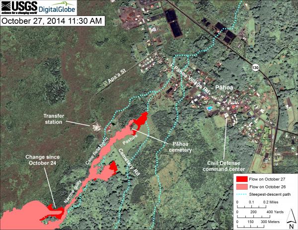
This map uses a satellite image acquired in March 2014 (provided by Digital Globe) as a base to show the area around the front of the June 27th lava flow. The area of the flow on October 26, 2014, at 12:30 PM is shown in pink, while widening and advancement of the flow as mapped on October 27 at 11:30 AM is shown in red. The dotted blue lines show steepest-descent paths in the area, calculated from a 1983 digital elevation model (DEM).
The flow advanced about 180 meters (200 yards) during the preceding 23 hours, and reached thick vegetation beyond the northeast edge of the lush pasture that the flow had been traversing. At the time of mapping, the flow was 540 meters (590 yards) directly upslope from Pāhoa Village Road. The latitude and longitude of the front of the narrow finger of lava advancing toward Pāhoa was 19.49307, -154.95469 (Decimal Degrees; WGS84). Though not shown on this map, the flow advanced an additional 30 meters (33 yards) by 4:30 PM.
Steepest-descent path analysis is based on the assumption that the DEM perfectly represents the earth's surface. DEMs, however, are not perfect, so the dotted blue lines can be used to infer only approximate flow paths. For calculation details, see http://pubs.usgs.gov/of/2007/1264/. (see large map) Image credit: USGS / HVO
HVO update issued 18:25 UTC on October 27 said that as on the previous evening, there was a small, rainfall-induced tilt signal at Puʻu ʻŌʻō yesterday evening, otherwise, no significant tilt was recorded.
"Seismic tremor remained steady. Glow was visible overnight above several outgassing openings in the crater floor, but there were no significant changes in activity within the crater.
The most recent sulfur-dioxide emission-rate measurement for the East Rift Zone was 340 tonnes per day (from all sources) on October 23, 2014.
Tiltmeters at the summit recorded no significant tilt over the past day. The lava lake level fluctuated during the course of the past day, but there was no significant net change. Seismic tremor beneath the summit varied with changes in spattering on the surface of the lava lake.
GPS receivers in the summit area have recorded slight contraction across the caldera since early July, but no significant change in elevation during that time. The most recent sulfur-dioxide emission rate measurements for the summit were 2,700–3,600 tonnes/day for the week ending October 21, 2014. A small amount of particulate material was carried aloft by the plume."
Update:
KILAUEA VOLCANO (VNUM #332010)
19°25'16" N 155°17'13" W, Summit Elevation 4091 ft (1247 m)
Current Volcano Alert Level: WARNING
Current Aviation Color Code: ORANGE
Scientists of the USGS Hawaiian Volcano Observatory conducted ground observations of the June 27th lava flow on Tuesday, October 28, 2014. The flow continued to move through private property today. The advance rate of the narrow leading edge has been variable over the past day, and as high as 16 meters (17 yards) per hour. The flow width was less than about 50 meters (55 yards) at the leading edge and as wide as 150 meters (165 yards) immediately upslope as breakouts have occurred along margins of the flow. Portions of the flow continued to inflate by as much as 2 meters as new fresh new lava was delivered to the advancing flow front.
As of 5:30 PM, the flow was 310 meters (340 yards) in a straight line distance from Pāhoa Village Road and about 900 meters (985 yards) in a straight-line distance from Highway 130.
The lava lobe upslope of Apa`a Street advanced about 30 meters (82 yards) since yesterday.
Daily updates about Kīlauea's ongoing eruptions, recent images and videos of summit and East Rift Zone volcanic activity, and data about recent earthquakes are posted on the HVO Web site at http://hvo.wr.usgs.gov.)
HVO scientists will continue to monitor the flow from the ground overnight and Wednesday; an overflight is scheduled for Wednesday morning, and new maps of the entire June 27th flow will be posted later in the day. A daily update will be posted in the morning, and status reports will be issued as new information becomes available. Updates are posted at http://hvo.wr.usgs.gov/activity/kilaueastatus.php.
Geologic summary
Kilauea volcano, which overlaps the east flank of the massive Mauna Loa shield volcano, has been Hawaii's most active volcano during historical time. Eruptions of Kilauea are prominent in Polynesian legends; written documentation extending back to only 1820 records frequent summit and flank lava flow eruptions that were interspersed with periods of long-term lava lake activity that lasted until 1924 at Halemaumau crater, within the summit caldera.
The 3 x 5 km caldera was formed in several stages about 1500 years ago and during the 18th century; eruptions have also originated from the lengthy East and SW rift zones, which extend to the sea on both sides of the volcano. About 90% of the surface of the basaltic shield volcano is formed of lava flows less than about 1100 years old; 70% of the volcano's surface is younger than 600 years. A long-term eruption from the East rift zone that began in 1983 has produced lava flows covering more than 100 sq km, destroying nearly 200 houses and adding new coastline to the island. (GVP)
- Hawai'i County Civil Defense Messages & Alerts
- HVO Kilauea status updates | Current SO2 Conditions | Maps | Photos & Video
Webcams
Featured image: Kilauea lava flow on October 27, 2014. Image credit: Hawai'i County Civil Defence
Commenting rules and guidelines
We value the thoughts and opinions of our readers and welcome healthy discussions on our website. In order to maintain a respectful and positive community, we ask that all commenters follow these rules:
We reserve the right to remove any comments that violate these rules. By commenting on our website, you agree to abide by these guidelines. Thank you for helping to create a positive and welcoming environment for all.