Five years of soil moisture and ocean salinity
The Soil Moisture and Ocean Salinity (SMOS) has orbited more than one billion kilometers around Earth for the past five years observing Earth's water cycle changes over the years. ESA's Earth Explorer SMOS mission was launched on November 2, 2009 from Plesetsk in Russia, carrying a novel radiometer sensor, to capture images of brightness temperature, which correspond to microwave radiation emitted from Earth's land and ocean surfaces. SMOS satellite observes two key variables in Earth's water cycle – soil moisture and ocean salinity.
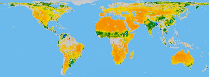
The animation above uses five years of its data to show how, on average, moisture in the soil changes with the seasons around the world. The animation illustrates how change according to season is pronounced in higher latitudes, but monsoon dynamics in the Indian subcontinent are also clearly visible. The ‘Sahel transition’ region in Africa is also well depicted. Seasonal flooding in regions such as La Plata in Argentina and the Orinoco Basin in Venezuela can also be seen.
SMOS also measure monthly differences in sea-surface salinity with respect to the average salinity. Data shows large deviations in the tropical Pacific Ocean and in the Indian Ocean, most likely linked to the occurrence of La Niña. La Niña is associated with cooler than normal sea-surface temperatures in the eastern Pacific, and the Indian Ocean Dipole, which describes sea-surface temperature differences between the eastern and western equatorial Indian Ocean.
The Soil Moisture and Ocean Salinity (SMOS) mission
SMOS mission is ESA's second Earth Explorer in orbit. It followed the Gravity field and steady-state Ocean Circulation Explorer (GOCE), launched in March 2009. Data from SMOS is important for weather and climate modeling, water resource management, agriculture and also contribute to the forecasting of hazardous events such as floods.
SMOS is a radio telescope in orbit, but pointing back to Earth not space. It's Microwave Imaging Radiometer using Aperture Synthesis (MIRAS) radiometer picks up faint microwave emissions from Earth's surface to map levels of land soil moisture and ocean salinity. SMOS provide global maps of soil moisture every three days within an accuracy of 4% at a spatial resolution of 50 km and global maps of sea-surface salinity down to 0.1 practical salinity units for a 30-day average over an area of 200×200 km (comparable to detecting 0.1 g of salt in a liter of water).
SMOS is distributing about 18 TB of data in public domain every year, of which around 13 TB are used by scientists and around 5 TB for near-realtime applications by operational users.
Explore SMOS
Featured image: Seasonal soil moisture from SMOS. (Credit: SMOS/Cesbio)
Commenting rules and guidelines
We value the thoughts and opinions of our readers and welcome healthy discussions on our website. In order to maintain a respectful and positive community, we ask that all commenters follow these rules.