Tropical Cyclone “05B” formed in Bay of Bengal
The fifth tropical cyclone of the Northern Indian Ocean season formed in the Bay of Bengal early on November 6, 2014.
Relatively high sea surface temperatures and moderate vertical wind shear will help it maintain strength and slightly intensify over the next two days as it drifts toward India in the central Bay of Bengal. It is expected to reach moderate tropical storm strength with maximum sustained winds of around 85 km/h (53 mph).
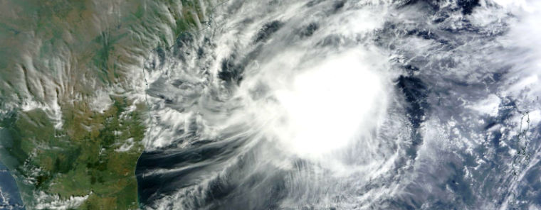
Terra/MODIS satellite captured image of Tropical Cyclone 5B in the Bay of Bengal at 05:05 UTC on November 6, 2014. (Credit: NASA Goddard/MODIS/LANCE Rapid Response Team)
.png)
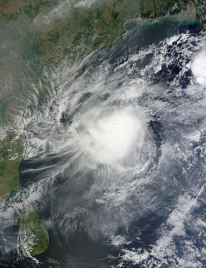
MTSAT RBTOP IR satellite image of center of TC 05B at 01:01 UTC on November 7, 2014. (Credit: NOAA/MTSAT)
Dry air mass ahead of the cyclone will cause it to rapidly weaken before landfall. JWTC forecasters expect Tropical Cyclone 5B to move more westward and make landfall near Chennai on November 9. Very rough sea conditions will affect Andaman Islands during next 12 hours and off Andhra Pradesh coast on November 8/9, 2014.
.png)
TCAC forecast track (Credit: IMD/TCAC)
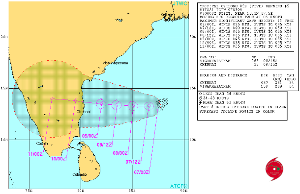
JTWC forecast track (Credit: JTWC)
Another, more dangerous cyclone may form next week in Gulf of Thailand. That system is expected to strengthen in the Andaman Sea early next week. Eastern India may face a tropical cyclone impact around the middle of next week.
Heavy and potentially flooding rain from the system will spread across southern Thailand and northern Malaysia. Flooding rain will also impact Andaman Islands as the system gains more strength.
.jpg)
METEOSAT-2 IR satellite image taken at 00:00 UTC on November 7, 2014. (Credit: METEOSAT/UW-CIMSS)
.jpg)
Satellite animations
- Storm-Centered Infrared (MTSAT2; NOAA/SSD)
- Storm-Centered Infrared (Aviation Color Enhancement) (MTSAT2; NOAA/SSD)
- Storm-Centered Water Vapor (MTSAT2; NOAA/SSD)
- Storm-Centered Visible (MTSAT2; NOAA/SSD)
- Storm-Centered Visible (Colorized) (MTSAT2; NOAA/SSD)
- Storm-Centered Infrared (Meteosat 7; CIMSS)
- Storm-Centered Enhanced Infrared (Meteosat 7; CIMSS)
- Storm-Centered Water Vapor (Meteosat 7; CIMSS)
- Storm-Centered Visible (Meteosat 7; CIMSS)
- Meteosat 7 Infrared
- Meteosat 7 Infrared (Color Background)
- Meteosat 7 Infrared (NHC Color Enhancement)
- Meteosat 7 Water Vapor
- Meteosat 7 Water Vapor (Color Background)
Featured image credit: Terra/MODIS satellite captured image of Tropical Cyclone 5B in the Bay of Bengal on November 6, 2014. (Credit:LANCE Rapid Response/MODIS)
Commenting rules and guidelines
We value the thoughts and opinions of our readers and welcome healthy discussions on our website. In order to maintain a respectful and positive community, we ask that all commenters follow these rules:
We reserve the right to remove any comments that violate these rules. By commenting on our website, you agree to abide by these guidelines. Thank you for helping to create a positive and welcoming environment for all.