Severe Tropical Cyclone “Pam” triggers red alerts in Vanuatu
At 02:00 UTC on March 12, Severe Tropical Cyclone "Pam" (Category 4) was located about 950 km (590 miles) Northwest of Nadi, Fiji, RSMC Nadi Tropical Cyclone Center said.
It had a central pressure of 935 hPa and average wind speeds of 185 km/h (114.9 mph) close to the center with gusts up to 250 km/h (155.3 mph). The system was moving south southeast at 9 km/h (5.5 mph). It is expected to maintain southerly track for the next 24 – 48 hours.
There is a high probability that Severe Tropical Cyclone "Pam" can further intensify and attain a Category 5 system in the next 12 – 18 hours.
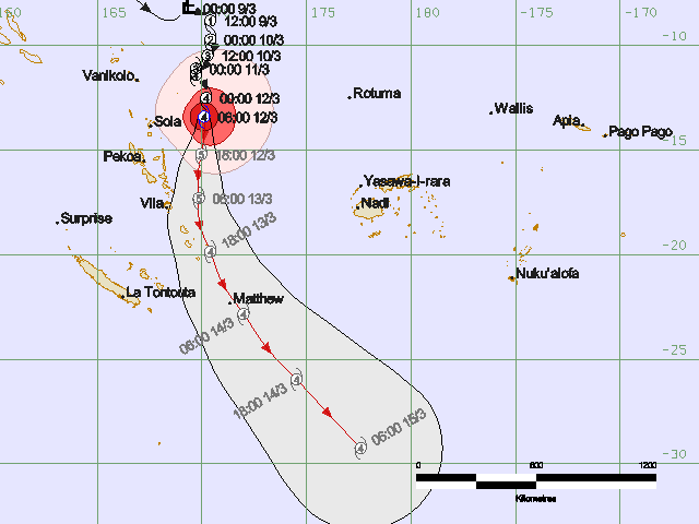
Severe Tropical Cyclone "Pam" forecast track by RSMC Nadi Tropical Cyclone Warning Centre on March 12, 2015.
Vanuatu Meteorology and Geo-Hazards Department issued Tropical Cyclone Warning for Torba, Sanma, Penama, Malampa, Shefa and Tafea provinces today.
At 06:00 UTC today, Pam was located about 285 km (177 miles) east northeast of Vanua Lava and 300 km (186.4 miles) northeast of Maewo. The system was moving in south direction at 17 km/h (10.5 mph) over the past 3 hours, the agency said.
The central pressure of the system was estimated at 930 hPa. Winds close to the center were estimated at 185 km/h (114.9 mph).
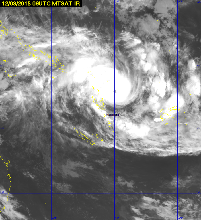
Image credit: MTSAT
Damaging gale force winds 75 km/h (46.6 mph) gusting to 105 km/h (65.2 mph) will affect Torba, Sanma, Penama, Malampa, extending to Shefa province later tonight or early tomorrow (local time). Winds over Penama, Malapa and Shefa province will increase to 160 km/h (99.4 mph) within the next 12 hours as the system continues to move southwards and intensify further.
Damaging gale force winds of 75 km/h (46.6 mph) will affect Tafea province within the next 12 to 24 hours.
Damaging winds and very rough to phenominal seas with heavy swells will affect Torba, Sanma, Penama, Malampa, Shefa and Tafea provinces. Heavy to torrential rainfall and flooding, including flash flooding are expected over low lying areas and areas close to river banks. Landslides are also expected. Coastal flooding is expected near the coastal areas.
The Vanuatu National Disaster Management Office advises people, that Red Alert is now current for Torba and Penama provinces. Yellow Alert is in effect for Sanma, Malampa, Shefa and Tafea provinces.
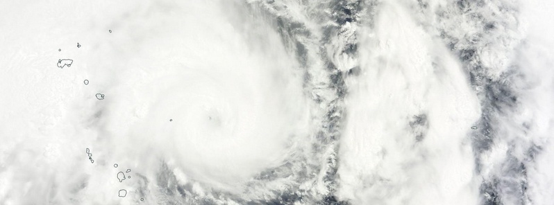
Severe Tropical Cyclone "Pam" on March 12, 2015. Image credit: NASA Terra/MODIS.
Additional warnings are also in effect in New Zealand as Pam continues to head south. Parts of the North Island are likely to be affected by severe weather on Monday, March 16. The areas cited under the warning are Gisborne and northern Hawkes Bay.
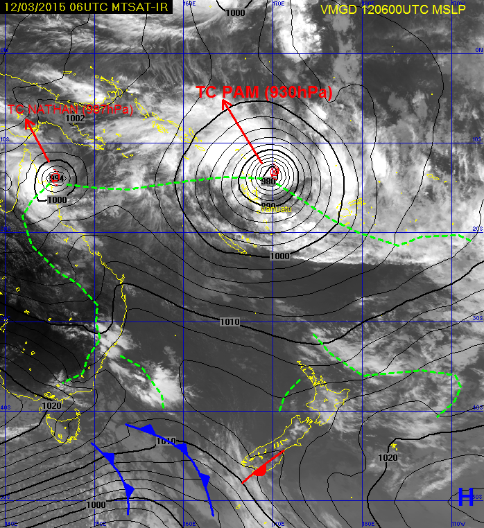
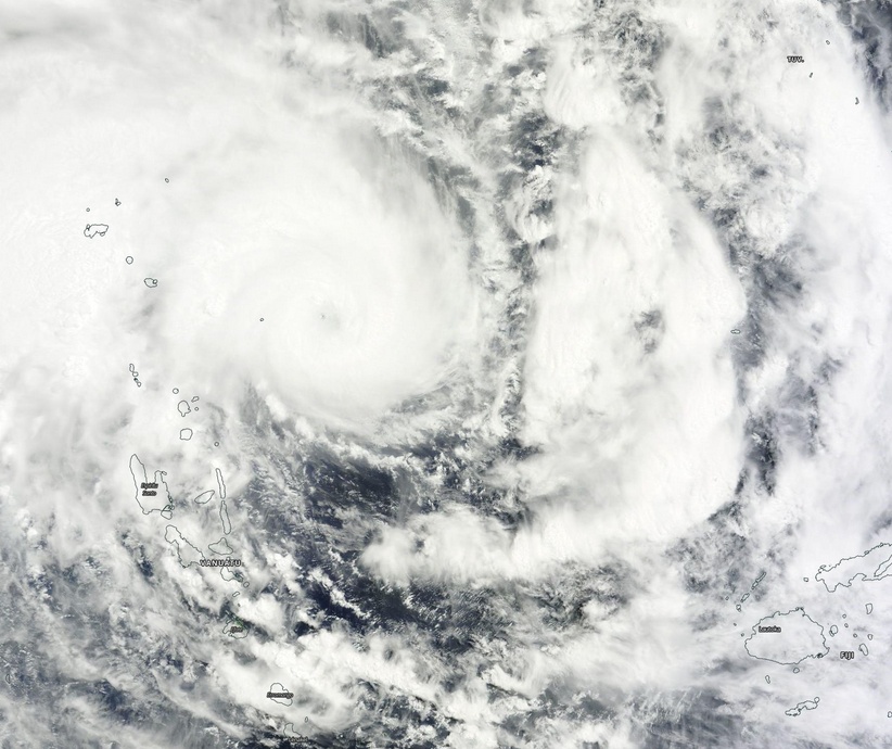
Image credit: VMGD.
The TRMM satellite had a good look at Pam on March 10, 2015 at 11:27 UTC when maximum sustained winds were estimated at 148 km/h (92 mph). TRMM's Microwave Imager showed that heavy rainfall from Pam covered a large area of the South Pacific Ocean near the Santa Cruz Islands. The eye of the intensifying tropical cyclone was shown passing to the east of the Santa Cruz Islands.
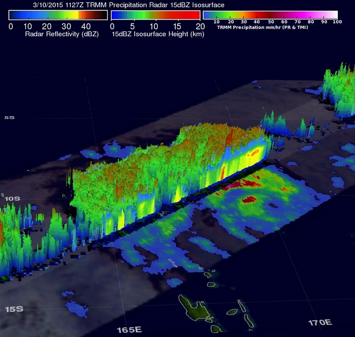
Image credit: NASA/JAXA/SSAI, Hal Pierce.
One of Pam's intense feeder (thunderstorm) bands northwest of the islands was dropping rain at a rate of over 158 mm (6.2 inches) per hour. TRMM's Precipitation Radar instrument covered the area to the northwest of Pam's eye and data was used to create a 3-D view of the storm that showed some cloud top heights there were reaching heights above 16 km (9.9 miles).
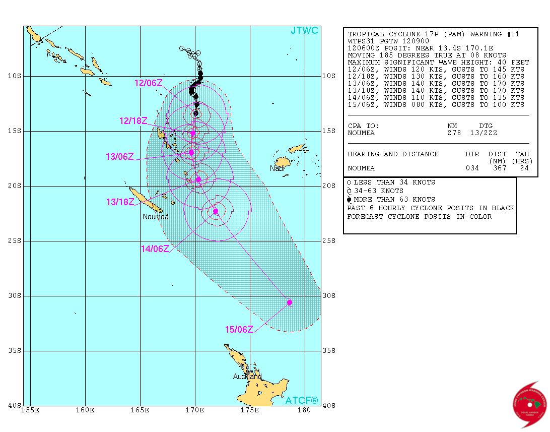
Severe Tropical Cyclone "Pam" forecast track by JTWC on March 12, 2015.
The Joint Typhoon Warning Center forecast takes Pam east of Vanuatu. The forecast then calls for Pam to become extra-tropical when it passes northeast of New Zealand.
Satellite animations
- Storm-Centered Infrared (Meteosat 7; NOAA/SSD)
- Storm-Centered Infrared (Aviation Color Enhancement) (Meteosat 7; NOAA/SSD)
- Storm-Centered Water Vapor (Meteosat 7; NOAA/SSD)
- Storm-Centered Visible (Meteosat 7; NOAA/SSD)
- Storm-Centered Visible (Colorized) (Meteosat 7; NOAA/SSD)
- Storm-Centered Infrared (Meteosat 7; CIMSS)
- Storm-Centered Enhanced Infrared (Meteosat 7; CIMSS)
- Storm-Centered Water Vapor (Meteosat 7; CIMSS)
- Storm-Centered Visible (Meteosat 7; CIMSS)
- Southwest Pacific Infrared (MTSAT; NOAA)
- Southwest Pacific Enhanced Infrared (MTSAT; NOAA)
- Southwest Pacific Water Vapor (MTSAT; NOAA)
Featured image: Severe Tropical Cyclone "Pam" on March 12, 2015. Image credit: NASA Terra/MODIS
Commenting rules and guidelines
We value the thoughts and opinions of our readers and welcome healthy discussions on our website. In order to maintain a respectful and positive community, we ask that all commenters follow these rules:
We reserve the right to remove any comments that violate these rules. By commenting on our website, you agree to abide by these guidelines. Thank you for helping to create a positive and welcoming environment for all.