Major M7.5 earthquake hits New Britain region generating small tsunami, Papua New Guinea
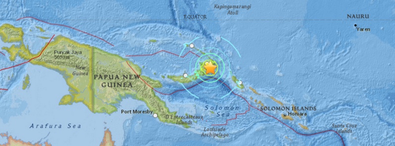
A major earthquake with recorded magnitude of 7.5 (USGS) hit off the coast of New Britain, Papua New Guinea at 23:48 UTC on March 29, 2015. USGS is reporting depth of 40 km (24.8 miles). Geoscience Australia is reporting M7.7 at a depth of 72 km (44.7 miles).
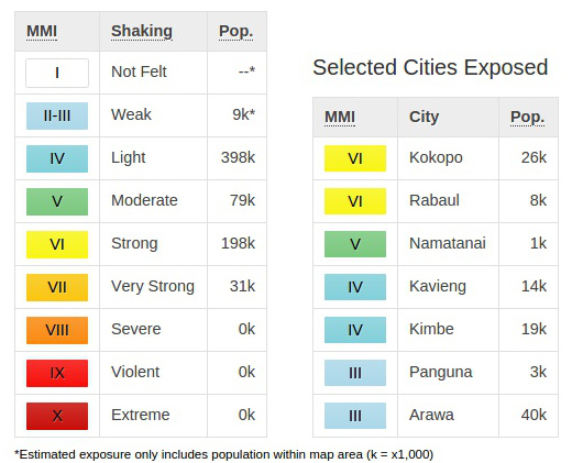
Epicenter was located 55 km (34 miles) SE of Kokopo, 281 km (175 miles) ENE of Kimbe, 310 km (193 miles) SE of Kavieng, and 367 km (228 miles) WNW of Arawa, Papua New Guinea.
There are about 238 546 people living within 100 km radius.
A small tsunami was generated by this event, however, the threat has now mostly passed without any reported damage. This does not mean that no damage was made as officials were still not available to make contact with more remote areas.
In their 02:30 UTC warning, PTWC said minor sea level fluctuations of up to 0.3 meters above and below the normal tide my continue over the next few hours.
Tarekukure Wharf, located some 450 km from the epicenter, measured waves of 0.03 meters (0.1 feet).
According to tsunami model height issued by GDACS at 02:48 UTC, the main tsunami threat was located around the immediate area of the earthquake:
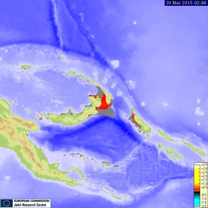
Tsunami maximum wave height. Source: JRC.
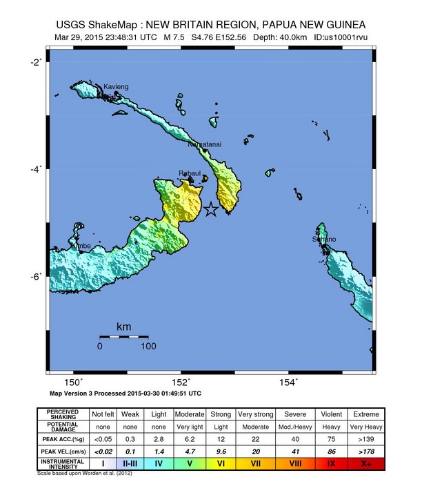
USGS issued green alert for shaking-related fatalities and economic losses. There is a low likelihood of casualties and damage.
Overall, the population in this region resides in structures that are vulnerable to earthquake shaking, though some resistant structures exist. The predominant vulnerable building types are unreinforced brick masonry and informal (metal, timber, GI etc.) construction.
Recent earthquakes in this area have caused secondary hazards such as tsunamis and landslides that might have contributed to losses.
This earthquake occurred as the result of thrust faulting on or near the plate boundary interface between the subducting Australia and overriding Pacific plates, USGS explains.
At the location of the earthquake, the Australia plate moves towards the east-northeast at a velocity of 105 mm/yr with respect to the Pacific plate, and begins its subduction into the mantle beneath New Britain and New Ireland at the New Britain Trench south of the earthquake. The moment tensor and depth of the event are consistent with thrust-type motion on the interface between these two plates. Note that at the location of the earthquake, some researchers divide the edges of the Australia and Pacific plates into several microplates that take up the overall convergence between Australia and the Pacific, including the Solomon Sea and South Bismark microplates local to this event. The Solomon Sea plate moves slightly faster and more northeasterly with respect to the Pacific plate than does Australia due to sea-floor spreading in the Woodlark Basin several hundred kilometers to the south of the March 29 earthquake, facilitating the classic subduction evident beneath New Britain and New Ireland.
The plate boundary between the Australia and Pacific plates in the Papua New Guinea region is very active seismically; 36 M 7+ events have occurred within 250 km of the March 29, 2015 earthquake over the past century. Few are known to have caused shaking-related fatalities because of the remoteness of the region, though a M 8.0 earthquake in November 2000 – one of three similarly sized events over a 2-day period – did cause several deaths. The largest nearby earthquake was an M 8.1 event, 70 km to the east of the March 29, 2015 earthquake, one of two M8+ earthquakes 140 km apart in July 1971.
Population exposure
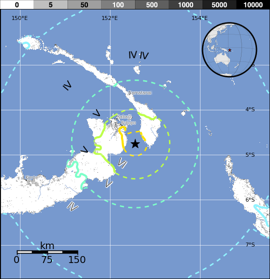
Population per ~1 sq. km. from LandScan
Aftershocks
By 07:25 UTC, USGS recorded 7 moderately strong aftershocks.
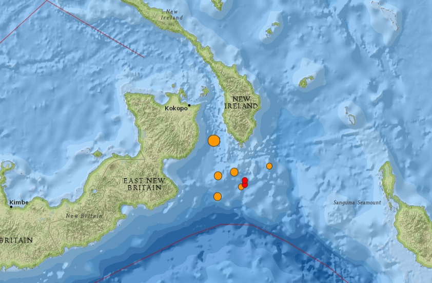
Image credit: USGS
- 4.92015-03-30 06:19:54 UTC35.0 km
- 4.72015-03-30 04:38:00 UTC43.4 km
- 5.32015-03-30 04:16:13 UTC35.0 km
- 4.72015-03-30 02:23:21 UTC35.0 km
- 4.72015-03-30 01:51:24 UTC35.0 km
- 5.02015-03-30 00:43:13 UTC35.0 km
- 5.72015-03-30 00:15:30 UTC35.0 km
- 7.52015-03-29 23:48:31 UTC40.0 km
Seismotectonics of the New Guinea Region and Vicinity
The Australia-Pacific plate boundary is over 4000 km long on the northern margin, from the Sunda (Java) trench in the west to the Solomon Islands in the east. The eastern section is over 2300 km long, extending west from northeast of the Australian continent and the Coral Sea until it intersects the east coast of Papua New Guinea. The boundary is dominated by the general northward subduction of the Australia plate.
Along the South Solomon trench, the Australia plate converges with the Pacific plate at a rate of approximately 95 mm/yr towards the east-northeast. Seismicity along the trench is dominantly related to subduction tectonics and large earthquakes are common: there have been 13 M7.5+ earthquakes recorded since 1900. On April 1, 2007, a M8.1 interplate megathrust earthquake occurred at the western end of the trench, generating a tsunami and killing at least 40 people. This was the third M8.1 megathrust event associated with this subduction zone in the past century; the other two occurred in 1939 and 1977.
Further east at the New Britain trench, the relative motions of several microplates surrounding the Australia-Pacific boundary, including north-south oriented seafloor spreading in the Woodlark Basin south of the Solomon Islands, maintain the general northward subduction of Australia-affiliated lithosphere beneath Pacific-affiliated lithosphere. Most of the large and great earthquakes east of New Guinea are related to this subduction; such earthquakes are particularly concentrated at the cusp of the trench south of New Ireland. 33 M7.5+ earthquakes have been recorded since 1900, including three shallow thrust fault M8.1 events in 1906, 1919, and 2007.
The western end of the Australia-Pacific plate boundary is perhaps the most complex portion of this boundary, extending 2000 km from Indonesia and the Banda Sea to eastern New Guinea. The boundary is dominantly convergent along an arc-continent collision segment spanning the width of New Guinea, but the regions near the edges of the impinging Australia continental margin also include relatively short segments of extensional, strike-slip and convergent deformation. The dominant convergence is accommodated by shortening and uplift across a 250-350 km-wide band of northern New Guinea, as well as by slow southward-verging subduction of the Pacific plate north of New Guinea at the New Guinea trench. Here, the Australia-Pacific plate relative velocity is approximately 110 mm/yr towards the northeast, leading to the 2-8 mm/yr uplift of the New Guinea Highlands.
Whereas the northern band of deformation is relatively diffuse east of the Indonesia-Papua New Guinea border, in western New Guinea there are at least two small (<100,000 km²) blocks of relatively undeformed lithosphere. The westernmost of these is the Birds Head Peninsula microplate in Indonesia's West Papua province, bounded on the south by the Seram trench. The Seram trench was originally interpreted as an extreme bend in the Sunda subduction zone, but is now thought to represent a southward-verging subduction zone between Birds Head and the Banda Sea.
There have been 22 M7.5+ earthquakes recorded in the New Guinea region since 1900. The dominant earthquake mechanisms are thrust and strike slip, associated with the arc-continent collision and the relative motions between numerous local microplates. The largest earthquake in the region was a M8.2 shallow thrust fault event in the northern Papua province of Indonesia that killed 166 people in 1996.
The western portion of the northern Australia plate boundary extends approximately 4800 km from New Guinea to Sumatra and primarily separates Australia from the Eurasia plate, including the Sunda block. This portion is dominantly convergent and includes subduction at the Sunda (Java) trench, and a young arc-continent collision.
In the east, this boundary extends from the Kai Islands to Sumba along the Timor trough, offset from the Sunda trench by 250 km south of Sumba. Contrary to earlier tectonic models in which this trough was interpreted as a subduction feature continuous with the Sunda subduction zone, it is now thought to represent a subsiding deformational feature related to the collision of the Australia plate continental margin and the volcanic arc of the Eurasia plate, initiating in the last 5-8 Myr. Before collision began, the Sunda subduction zone extended eastward to at least the Kai Islands, evidenced by the presence of a northward-dipping zone of seismicity beneath Timor Leste. A more detailed examination of the seismic zone along it's eastern segment reveals a gap in intermediate depth seismicity under Timor and seismic mechanisms that indicate an eastward propagating tear in the descending slab as the negatively buoyant oceanic lithosphere detaches from positively buoyant continental lithosphere. On the surface, GPS measurements indicate that the region around Timor is currently no longer connected to the Eurasia plate, but instead is moving at nearly the same velocity as the Australia plate, another consequence of collision.
Large earthquakes in eastern Indonesia occur frequently but interplate megathrust events related to subduction are rare; this is likely due to the disconnection of the descending oceanic slab from the continental margin. There have been 9 M7.5+ earthquakes recorded from the Kai Islands to Sumba since 1900. The largest was the great Banda Sea earthquake of 1938 (M8.5) an intermediate depth thrust faulting event that did not cause significant loss of life. (USGS) More information on regional seismicity and tectonics
Featured image credit: USGS
Commenting rules and guidelines
We value the thoughts and opinions of our readers and welcome healthy discussions on our website. In order to maintain a respectful and positive community, we ask that all commenters follow these rules.