Alert level raised after Raung volcano erupts, Indonesia
After an increase in volcanic activity which started on June 21, Raung volcano in East Java, Indonesia erupted late Sunday, June 28, causing ash to land in villages about 10 km away from the crater.
Authorities raised the alert level from 'waspada' (alert) to 'siaga' (high alert). With this higher alert level, local residents and climbers should not approach areas within a 3 km from the crater.
“Mt. Raung’s status has been increased to siaga starting from 09:00 local time on Monday, June 29 [02:00 UTC] because of increases in its earth tremors,” the PVMBG's head of volcano observation and surveillance division, Gede Swastika, said.
The agency had monitored Mt. Raung during the last two weeks and found that its volcanic activities had continued to increase.
“The volcano’s eruption has continued to increase. It spewed blazing lava and volcanic ash around 300 meters high into the sky,” Gede said and added that earthquake tremors had continued to increase with a maximum amplitude of 21 millimeters. Thundering noises could be heard from the Mt. Raung observation post in Songgon, Banyuwangi, although it could not visually record the volcano’s eruptions because of the clouds covering its peak." (JP)
According to other media reports, the eruption on June 28 could be heard 20 km away from the crater.
29 Juni – 19:10 pm #Raung volcano meraung view PGA #Ijen @infobencana @POSSARJEMBER @KepoBanyuwangi @POSSARJEMBER pic.twitter.com/SkCbfinVJP
— Leopold Kennedy Adam (@LeopoldAdam) June 29, 2015
On June 27, the Darwin VAAC said volcanic ash plume from Raung was observed reaching 3.65 km at 10:30 UTC on June 26. Ash was not identifiable on satellite imagery during the last 15 hours and current data sources do not indicate an ongoing eruption. However, the hotspot continues to be evident on satellite imagery.
Their next volcanic ash advisory, issued at 06:00 UTC on June 29, said volcanic ash is reaching 3 km, according to ground reports. A persistant hotspot remains identifiable.
Aviation Color Code is set on Orange. The situation will be closely monitored, the agency said.
Geologic summary
Raung, one of Java's most active volcanoes, is a massive stratovolcano in easternmost Java that was constructed SW of the rim of Ijen caldera. The 3332-m-high, unvegetated summit of Gunung Raung is truncated by a dramatic steep-walled, 2-km-wide caldera that has been the site of frequent historical eruptions.
A prehistoric collapse of Gunung Gadung on the west flank produced a large debris avalanche that traveled 79 km from the volcano, reaching nearly to the Indian Ocean. Raung contains several centers constructed along a NE-SW line, with Gunung Suket and Gunung Gadung stratovolcanoes being located to the NE and west, respectively.
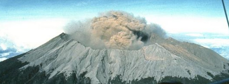
Featured image: Raung Volcano. Photo by Willem Rohi, 1988 (Volcanological Survey of Indonesia).
Commenting rules and guidelines
We value the thoughts and opinions of our readers and welcome healthy discussions on our website. In order to maintain a respectful and positive community, we ask that all commenters follow these rules:
We reserve the right to remove any comments that violate these rules. By commenting on our website, you agree to abide by these guidelines. Thank you for helping to create a positive and welcoming environment for all.